Tuesday, March 31, 2015

March 31, 2015 Fire Report

Ft. George Fire
  • Located southeast of Fort Pierre, on Lower Brule Agency
  • Size is estimated at .2 acre
  • Resources responded
Incident #2 - Named Fisherman Flats
  • Located 1 mile southwest of the Custer State Park Airport
  • Size is estimated at .1 acre
  • This fire has been knocked down and contained
  • State resources responded
  • Firefighters will continue mop-up this afternoon and evening


Sunday, March 29, 2015

Alexander Fire

Located in the Palmer Gulch area
1/4 acre in size
Local and federal resources on scene
Cause is a down power line
Contained
20 to 30 mph winds reported

Saturday, March 28, 2015

Sheep Draw Fire


Jonathan Moor is now the Public Information Officer 
assigned to the Sheep Draw Fire. 
Media and public can reach him at: 406.366.9274.
______________________________________________________

Update provided at 5:55 PM on April 2, 2015

  • As of 6:00 PM the Sheep Draw Fire is 100% contained
  • This fire continues to be in mop up, patrol, and rehab status
  • Investigation of cause is ongoing


Update provided at 9:06 PM on April 2, 2015
  • 85% Contained
  • This fire is now in patrol and mop up status
  • The Incident Commander is currently working with local ranchers and the volunteer fire department
  • The fire remains under investigation


Update provided at 3:07 PM on April 1, 2015
 U.S. Forest Service Wildland Firefighters monitor smoldering logs in high winds at the Sheep Draw Fire. High winds have kept logs and stumps burning, however the crews have managed to keep the fire from spreading any further.  (photo Jonathan Moor)

Kevin Woster, a Reporter with KELO Rapid City, collects b-roll footage of a burning log at the Sheep Draw Fire. The 13,949-acres fire drew the attention of a number of regional media outlets including print, radio and television. (photo Jonathan Moor)


Update provided at 11:48 PM on April 1, 2015

  • Size remains at 13,949 acres
  • 70% contained, although an increase in containment is expected 
  • 35-45 mph winds currently over the fire with gusts up to 50 mph
  • Fireline is holding well against the winds
  • Fire Managers have started to demob equipment and hand crews
  • Rehab efforts are currently taking place on the interior dozer line
  • The public can expect to see interior smoke until we receive significant precipitation


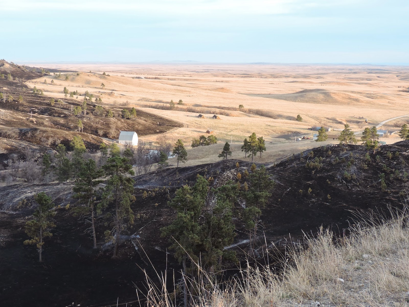
Photos updated at 8:15 PM on March 31, 2015
Photos taken by Jonathan Moor at the close of the day today.
A few pockets of smoke linger in the draws and coulees.
 However, firefights have managed to achieve 70 percent containment.
This barn still stands at sunset after the Sheep Draw Fire passed close by.


Photos updated at 5:48 PM on March 31, 2015

Photos taken by Air Attack who flew over the fire today.
What a difference a day makes - this is the northeast flank of the fire.

Some smoke still visible coming from interior portions of the fire.

Update provided at 4:16 PM on March 31, 2015

  • Size is now estimated at 13,949 acres
  • The fire is now 70% contained
  • One non-commercial structure was burned. The structure was a protective shed for a natural gas well. The gas well caught fire the first day and was put out by the first night. 

Update provided at 12:06 PM on March 31, 3015

  • As of 6:00 PM last night, two Dozers met and tied in the line around the fire (one from the north and one from the south)
  • The successful burnout operation ended at 10:00 PM last night
  • No injuries of both firefighters and the public have been reported 
  • This fire is burning mainly on public and private land with a small portion of Bureau of Land Management Land

Fact Sheet updated at 11:54 on March 31, 2015

Size            10,200 acres (as of 8 a.m. March 31, 2015) Type 3 Incident
Started      March 28, 2015
Location    7 mi. East, 12 mi. South of Camp Crook, SD
Cause        Unknown (under investigation)
Incident Command Post      At Harding VFD Station  (mobile trailer)
Incident Commander           Jim Strain
Public Information Officer   Jonathan Moor
            cell (406) 366-9274       jmoor@blm.gov

Lead Agency      Division of Wildland Fire, South Dakota Dept. of Agriculture

Supporting Agencies

  • South Dakota National Guard
  • U.S. Bureau Of Land Management
  • U.S. Forest Service
  • South Dakota Highway Patrol
  • Harding County: Sheriff’s Office; Emergency Management; Board of Commissioners
Personnel  111

Vehicles

  • 2 Type-1 Helicopters (South Dakota National Guard)
  • 1 King Air 90 Twin Engine Fixed Wing Air Attack Platform (State of South Dakota)
  • 2 Road Graders
  • 3 Bulldozers
  • 4 Water Tenders
  • 13 Type-6 Engines
  • 2 Type-4 Engines

Incident Objectives

  • Ensure Public and Firefighter safety at all times
  • Hold fire west of Harding Road
  • Hold fire north of Collins Road
  • Protect grazing, timber, and sagebrush values north of West Short Pines Hills


Map updated at 11:41 AM on March 31, 2015


Photos updated at 10:44 AM on March 31, 2015
Sheep Draw Fire


Photo updated at 7:08 PM on March 30, 2015


Sunset at the Sheep Draw Fire. Photo taken from the Incident Command Post

Photos updated at 6:02 PM on March 30, 2015
Photos taken on a recon flight this afternoon.
View from the southeast side of the fire along the Harding Road.

View from the southwest side of the fire. Looking at slop over into a draw.

View from the northwest side of the fire which is the most active portion. 

View from the northwest flank of the fire.  

Updated at 4:46 PM on March 30, 2015
  • Fire Command flew over the fire today to gain fire intelligence.   
  • The latest conservative estimate in size is 10,200 acres.
  • There are no changes on the incident status, firefighters are still in full suppression strategy.  Fire Managers will continue to ramp up personnel working with the Incident Management Team (IMT) in light of critical incident fire weather forecasted for tomorrow.  

Photo taken from the Incident Command Post located in Harding, SD.

Updated at 12:33 PM on March 30, 2015
  • The Sheep Draw Fire is now 15% contained.
Black Hat Hand Crew, Crew Boss on the Sheep Draw Fire

Map of the Sheep Draw Fire updated at 11:18 AM on March 30, 2015


Photos updated at 10:55 AM on March 30, 2015
Sheep Draw Fire
National Guard Black Hawk Helicopter 

Sheep Draw Fire - Dozer putting in fireline


Sheep Draw Fire 

Updated 10:16 AM, March 30 2015
  • Size remains at 6,430 acres
  • A Fire Investigator is on scene working to determine cause
  • Four primary structures  and 18 outbuildings (which include natural gas wells/sites) are threatened.  Structure protection is in place and Fire Officials are working with local resources to ensure public and firefighter safety.
  • This fire is burning in Fuel Models 2 (grass) and 7 (timber overstory with pockets of heavier fuels)
  • A Type 3 team has assumed command as of 8:00 AM today
  • Fire Officials are working on a complexity analysis today to determine if this fire should be typed at a 2 level (meaning a more complex incident)
  • No injuries of firefighters or the public have been reported
  • Weather right now on scene is 52 degrees with wind gusts up to 18 MPH (moderate winds) and the relative humidity at 45% 
  • The temperature is expected to reach 69 degrees today with higher wind gusts up to 38 MPH.  There is currently a Fire Weather Watch in Harding County with high winds are expected.

Updated 9:20, Sunday March 29, 2015

Fire is now 6430 acres


Updated 2:45, Sunday March 29, 2015

Fire is now 5600 acres
Jim Strain from SD Wildland Fire is the type 3 Incident Commander
2 helicopters from SD National Guard have been ordered
Fire officials estimate containment/control in 4 to 5 days


Updated 11:11, Sunday March 29,2015

Fire size is 5000+ acres on private and state lands. A Type 3 team has been ordered. No injuries have been reported. The cause is under investigation.


Located in the West Short Pines of Harding County
Estimated size is 2000 Acres
Local and Federal resources on scene and a 20 person hand crew and dozer have been requested
Cause is unknown at this time
Sustained winds of 40+ mph with wind gusts of 70+ reported

Tuesday, March 24, 2015

How to Obtain Fire Information in the Great Plains Initial Attack Zone

Rapid City, SD – Public Information Officers (PIOs) from Federal and State agencies continue to work together to distribute information about initial attack fires within the Great Plains initial attack zone.
(Note: The Great Plains initial attack zone includes public and private land in the Black Hills in South Dakota, in east/northeastern Wyoming and western Nebraska.)
One common phone number, e-mail, blog, and Twitter account are staffed during initial attack fires by an on call PIO who works closely with the Great Plains Dispatch Center to provide interagency fire information.
Great Plains Fire Information/PIO Contact Information:

It is important to note that people who wish to receive fire information within the Great Plains initial attack zone, should subscribe to the blog, follow the Twitter account or subscribe to the Atom Feed (available on blog) as news releases are no longer sent out via the Google e-mail account.
If a post has been made on the blog, one automatic e-mail a day will be sent to those who subscribe with all of the daily fire updates. The blog link may also be checked anytime of the day to see any updates that have been made on initial attack fires.
To subscribe to the blog:
  1.            Click on http://gpfireinfo.blogspot.com/
  2.       In the “Follow by E-mail” box on the right side of the webpage, enter your e-mail address that you wish to     receive updates at.
  3.       Hit “Submit”
  4.       A pop-up box will appear asking you to enter a word in a box to verify that your e-mail is not spam.
  5.            Enter the word that is shown and then click “Complete Subscription Request”
  6.             Done

For questions, please call the PIO phone number at (605) 923-8868 or e-mail greatplainsfireinfo@gmail.com.
###

Friday, March 20, 2015

Exit 55 Fire

Updated at 10:42 AM on Saturday, March 21
  • Command of this fire has been turned over to the Black Hawk Volunteer Fire Department

Updated at 6:52 PM on Friday, March 20 
  • Located just west of Exit 55 on Interstate 90 in Pennington County
  • Some vehicles and other man-made improvements were threatened, no actual serious damage was reported from this fire
  • Size reached 16.1 acres
  • Local, state, and federal resources responded
  • Cause is under investigation
Due to the close proximity of the Exit 55 and Northdale Fire, the driving lane of eastbound I-90 was closed for about 1.5 hours for firefighter safety.


Northdale Fire

Updated at 10:42 AM on Saturday, March 21
  • Command of this fire has been turned over to the Black Hawk Volunteer Fire Department

Updated at 6:33 PM on Friday, March 20
  • Located in Black Hawk in Meade County
  • Two outbuildings/sheds have been destroyed by this fire
  • Several power poles and other utility infrastructure were also damaged
  • There were several cases of citizens with smoke inhalation and one with minor 1st degree burns
    • Rapid City Fire Department medical staff set up handled the medical issues
  • No evacuations were ordered for this fire, however Northdale Drive was closed to any which kept residents from getting to their homes
  • This fire is now at 5.7 acres
  • Cause of the fire remains under investigation


There are currently two separate fires to report that are an estimated 1.5 miles apart off of Interstate 90 - Please see the separate Exit 55 blog post.

Updated at 4:40 PM on Friday, March 20
  • Located along Interstate 90 from mile marker 52 to mile marker 54
  • Estimated size is 8 acres
  • Local, state, and federal resources have responded
  • Cause is under investigation 
  • Reported that no homes are on fire 
    • Two outbuildings have burned
  • No evacuations at this time 
  • At this time Nortdale Road is currently closed  
    • If residents of the Northdale Subdivision aren't already at their residence, they will not be allowed access due to high traffic and the challenges this is presenting firefighters.  
  • The Incident Commander anticipates Northdale Road be reopened at the estimated time of 5:00 PM
Initial size up information is currently being collected on this incident.  Updated information will be posted as received.

Thunderhead Falls Fire


Updated at 11:15 am
  • Located on Thunderhead Falls Road west of Rapid City
  • Estimated size is .10 acres
  • State and local resources have responded

Initial size up information is currently being collected on this incident.  Updated information will be posted as received.

Thursday, March 19, 2015

Deadman Fire


Incident #1 - Updated at 4:49 pm

  • Located off of Vanocker and Galena Roads
  • Local, federal, and state resources have responded
Initial size up information is currently being collected on this incident.  Updated information will be posted as received.

Incident #1 - Named the Deadman Fire
Updated at 6:27 pm
  • Estimated at 3-5 acres
  • Resources are on scene
  • This fire is burning in steep and rugged terrain
  • A Fire Investigator has been ordered to determine cause
8:15 pm Update
  • US Forest Service jurisdiction
  • located on the Meade/Lawrence county line
Firefighters strengthen fireline on the Deadman Fire.


8:26 am Update on March 20
  • One engine staffed the fire overnight
  • Three hand crews and 4 engines will continue to staff the fire throughout the day
Deadman Fire taken on initial attack.
3:04 pm Update 
  • 6.6 acres
Deadman Fire


Sunday, March 15, 2015

March 15, 2015 Fire Report

Incident #1

  • Located 2 miles west of Interior, SD
  • Resources responded
Incident #2 - False Alarm
  • Located off of Deerfield Road
  • Resources responded
Initial size up information is currently being collected on these incidents.  Updated information will be posted as received.

Friday, March 13, 2015

March 13, 2015 Fire Report

Updated at 4:44 PM
Hollow Point Fire 

  • Located off of South Highway 16 on Beretta Road
  • Estimated size is .10 acre
  • Local, federal, and state resources responded
  • Cause is under investigation
Stewart Fire
  • Located North of Pierre, SD in the Gray Goose area
  • Estimated size is 15 acres
  • Resources responded
Johnson Fire 
  • Located in Weston County approximately 4 miles east of Newcastle
  • Estimated size .43 acres
  • Resources responded

Thursday, March 12, 2015

March 12, 2015 Fire Report

Incident #1 - Potter Road Fire
Updated at 7:06 PM
  • Located in the Doty area south west of Black Hawk
  • Resources are responding
Updated at 7:31 PM
  • Size is estimated at .1 acre


Incident #2 - False Alarm
  • Located in Crook County near Aladdin, WY
  • Resources are responding
Initial size up information is currently being collected on these incidents.  Updated information will be posted as received.


Holmes Fire

  • Located 7 miles northeast of Hulett, WY
  • County resources responded at roughly 6:40 PM on March 12
  • Estimated size is 65 acres
  • The Smokebusters (WY Department of Corrections Crew) have been ordered for today
  • Cause is under investigation


Wednesday, March 11, 2015

Turkey Ridge Fire

Incident #1 - Named the Turkey Ridge Fire
(Updated at 4:08 PM on March 11)
  • A fire has been reported in the Hermosa area
  • State and local resources are currently responding to the scene
Dispatch is collecting initial size up information.  Updated information will be posted as received.

4:47 PM Update
  • State and local resources arrived on scene
  • Size is estimated at 3-6 acres
5:06 PM Update
  • Fire location is in the Ghost Canyon area off of Turkey Ridge Road
  • Size has been determined to be 5 acres
  • There is currently active fire burning with some smoldering
  • This fire is burning in grass and timber
  • A Fire Investigator is on scene to determine cause
  • Structures threatened on this incident
Turkey Ridge Fire

9:06 PM Update
  • Size has been determined to be 7.25 acres
  • There is no containment percentage at this time
  • Forward progression of the fire has been stopped
  • Mop up efforts will continue throughout this Operational Period
  • A wind event is expected from roughly 9:00 PM to Midnight
  • Overnight incident staffing will depend on the expected wind event
Photo of the Turkey Ridge Fire taken earlier this evening.  

 March 12, 2015

8:10 AM Update 
  • Firefighters were released at 1:00 AM last night
  • Although wind gusts were up to 20 MPH, firefighters were still able to hold the fireline
  • State resources including engines and hand crews are staffing the fire today
  • Firefighters will continue to mop up
  • This fire is now contained
3:16 PM Update
  • The Turkey Ridge Fire was called controlled at 11:48 AM today
  • All resources are currently off of this fire


Tuesday, March 10, 2015

North Pole Fire

Incident #1  -- Named the North Pole Fire
(Initial update provided at 4:28 PM on March 10, 2015)
  • The North Pole Fire is located in the area of Highway 16 and Renegade Road west of Custer
  • Local, state, and federal resources are responding
  • Estimated size is 5 acres
  • There is the possibility of structures threatened 

Dispatch is collecting initial size up information.  Updated information will be posted as received.

5:08 PM Update
  • US Forest Service, South Dakota Wildland Fire, and local VFD engines are en route.  USFS Dozer is en route. The South Dakota Wildland Fire Division Black Hat and Bear Mountain Hand Crews are en route.  SD DOC crews are in process of mobilization as well.
  • A fire investigator has been ordered and is en route
  • Jurisdiction remains unknown
5:43 PM Update
  • North Pole Road has been CLOSED from Highway 16 to Renegade Road
  • Firefighters will continue to work the incident tonight and throughout tomorrow until the incident is contained
8:31 PM Update
  • Estimated size is now at 60 acres
  • Firefighters and Great Plains Dispatch will continue to staff this incident tonight and tomorrow (personnel will continue to evaluate and provide for the incident needs)
  • Resources are being planned and ordered for the next operational period tomorrow
  • No ownership has been determined at this time although the fire has burned both private property and US Forest Service land
  • This fire is burning in Fuel Type 2 (Herbaceous fuels) and Fuel Type 8 (slower burning heavy fuels)
  • An Incident Command Post has been established in Custer on this Type 3 incident

March 11, 2015

5:30 AM Update
  • Size is 59.3 acres
  • Multiple agency engines along with state hand crews monitored the fire overnight
  • No known significant changes to report from the overnight shift
  • No injuries to report at this time
  • Firefighters were ordered for the next operational period; They will receive a briefing later this morning and will continue fire suppression efforts
8:30 AM Update
  • Daytime Operational resources are now assigned, the night shift has been released
  • The fire held well last evening on the road system, dozer line, and hand line
  • State and federal resources along with the Custer Volunteer Fire Department water tender are the current resources assigned
  • No percentage containment at this time
  • Smoke is a concern in the area.  Motorists are encouraged to reduce speed but NOT stop along the highway and impede traffic.  
  • State and federal fire investigators continue to work on determining cause
10:00 AM Update
12 Noon Update
4:15 PM Update

March 12, 2015

9:30 AM Update
6:00 PM Update
  • The North Pole fire is 100% contained. This will be the last North Pole fire update unless something significant occurs.

March 16, 2015

3:oo PM Update
  • The North Pole fire is 100% controlled. 

Monday, March 9, 2015

Fire Report March 9, 2015

Vanocker Pit Fire

  • Located in the Vanocker Canyon area
  • Size is estimated at .2 acres
  • US Forest Service has responded
  • Fire Cause is under investigation
Incident #2
  • Located near Runkle Road in the Vanocker Canyon area
  • SD Wildland Fire is investigating and will size up
  • This incident has been deemed a false alarm

Updated information will be posted as it is received.


Saturday, March 7, 2015

March 7, 2015 Fire Report

Limestone Road Fire
  • Located north west of Custer on the Custer Limestone Road 
  • Size is estimated at 4.9 acres
  • Burning in grass and downed slash
  • Resources have responded to include the local and federal resources
Harper Road Fire
  • Located north of Custer
  • Size is estimated at 3 acres
  • Resources have responded to include local and state resources