- The Storm Hill fire is 100% contained.
- Crews will continue patrol status through the week.
- Cause remains under investigation.
Tuesday, April 26, 2016
Storm Hill Fire Update - Tuesda 4/26, 2016 at 10:30 AM
Monday, April 25, 2016
Storm Hill Fire Update - Monday 4/25, 2016 at 4:20 PM
- The Storm Hill fire is now 100% contained. When a fire is referred to as contained, it means a line is constructed around the fire perimeter, firefighters are working to extinguish or remove burning material near containment lines, and the spread is stopped.
- Firefighters expect the line to hold with minimal firefighter intervention. Today's plan to increase the security patrol fireline to 60 feet was successful.
- This fire will transfer from a Type 3 incident to a Type 4 - which indicates that the complexity of this incident has lessened.
- Cause remains under investigation.
Storm Hill Fire Update - Monday, 4/25 @ 7:30 AM
* Fire now 75% contained; firefighters report a "good night" and have completed a 30 ft. security patrol line around all of fire. Today plan to increase it to 60 ft. security patrol line.
* No precipitation on fire overnight.
* Size 193 acres, federal and private lands
* Traffic Hazards! Many 'Looky Loo's' causing safety hazard as highway has many blind curves. PLEASE HELP KEEP OUR FIREFIGHTERS AND ALL TRAVELERS IN THE AREA SAFE!
* No precipitation on fire overnight.
* Size 193 acres, federal and private lands
* Traffic Hazards! Many 'Looky Loo's' causing safety hazard as highway has many blind curves. PLEASE HELP KEEP OUR FIREFIGHTERS AND ALL TRAVELERS IN THE AREA SAFE!
Sunday, April 24, 2016
#StormHillFire Sunday evening update

Photo shows the significant fuels, timber 'dead and down' and why folks will see smoke for several days. Weather conditions have improved containment. Crews have the edges secured and continue mop-up.
Saturday, April 23, 2016
Storm Hill Fire
Update 4/24/16 at 3:30 PM
* Fire size: GPS today - 192 acres, private and US Forest Service Land
* 50% contained
* Resources: Federal, state and local
* Human caused - under investigation
* Fuels: Heavy bug killed area; smoke will be visible for several days
Update 4/24/16 at 8:30 AM
Photos of Storm Hill Fire from last night and early this morning: (Photo credit: Randy Albright)
* Fire size estimated at 100+ acres.
* Hwy. 16/385 re-opened at 2:30 AM; If traveling in the area, Be alert for fire operations traffic
* Cause: investigation continues - determined 'not natural cause.'
* Fire 50% contained, line established all around fire


Hwy. 16/385 will be closed for the night.
Update at 12:30 AM: Fire estimated at 100 acres. Burn-out operations being finalized.
Updated photos at 11:15 PM by Rob Lehmann, Incident Commander. Location by Mitchell Lake


New photos from Jim Burk, SDWF at 9:40 PM:


* No containment report at this time, but firefighters have line established on the east, northwest and south side of the fire. Burn out operations will continue through the night.
* Fuels are bug killed trees with much 'dead & down'
New photo from 8:40 PM by Jim Strain SDWF Chief of Ops taken from Hwy. 385 by Three Forks:

Update at 7:40 PM - Hwy. 16/385 will be closed for the night.
* Reported April 23, 2016 at 2:05 PM
* Located east of Hill City by the sawmill - private and US Forest Service lands
* Structures threatened
* 25 acres
* Resources on-site: Federal, State of SD and Pennington County,hand crew
* Cause undetermined, investigation requested
* Two photos from Winston Cadotte, SDWF
#StormHillFire


* Fire size: GPS today - 192 acres, private and US Forest Service Land
* 50% contained
* Resources: Federal, state and local
* Human caused - under investigation
* Fuels: Heavy bug killed area; smoke will be visible for several days
Update 4/24/16 at 8:30 AM
Photos of Storm Hill Fire from last night and early this morning: (Photo credit: Randy Albright)
* Fire size estimated at 100+ acres.
* Hwy. 16/385 re-opened at 2:30 AM; If traveling in the area, Be alert for fire operations traffic
* Cause: investigation continues - determined 'not natural cause.'
* Fire 50% contained, line established all around fire
Hwy. 16/385 will be closed for the night.
Update at 12:30 AM: Fire estimated at 100 acres. Burn-out operations being finalized.
Updated photos at 11:15 PM by Rob Lehmann, Incident Commander. Location by Mitchell Lake


New photos from Jim Burk, SDWF at 9:40 PM:


* No containment report at this time, but firefighters have line established on the east, northwest and south side of the fire. Burn out operations will continue through the night.
* Fuels are bug killed trees with much 'dead & down'
New photo from 8:40 PM by Jim Strain SDWF Chief of Ops taken from Hwy. 385 by Three Forks:

Update at 7:40 PM - Hwy. 16/385 will be closed for the night.
* Reported April 23, 2016 at 2:05 PM
* Located east of Hill City by the sawmill - private and US Forest Service lands
* Structures threatened
* 25 acres
* Resources on-site: Federal, State of SD and Pennington County,hand crew
* Cause undetermined, investigation requested
* Two photos from Winston Cadotte, SDWF
#StormHillFire


Photo at 4:40 PM from Jim Burk, SDWF

Photo at 6:35 from Josh Hoffmann, Black Hills NF:

Tuesday, April 19, 2016
Bulldog Fire
Bulldog Fire
* Reported 4/19/2016 at 3:47 PM
* Located west of the Black Hills National Cemetery - private land
* Size: <0.1 acre; Human caused
* One SD State engine on - scene
* Estimated containment at 5:30 PM
* Reported 4/19/2016 at 3:47 PM
* Located west of the Black Hills National Cemetery - private land
* Size: <0.1 acre; Human caused
* One SD State engine on - scene
* Estimated containment at 5:30 PM
Friday, April 15, 2016
Wednesday, April 13, 2016
Swint Well Prescribed Fire to Continue at Custer State Park
For Immediate
Release:
April 13, 2016
Contact: Jeni Lawver,
605.381.7232
Swint
Well Prescribed Fire to Continue at Custer State Park
RAPID CITY, S.D.- The South Dakota Department of
Agriculture’s Wildland Fire Division, South Dakota Game, Fish and Parks, and
Custer State Park will continue the Swint Well prescribed burn in Custer State
Park. Firefighters are planning on burning approximately 800 acres.
This burn is scheduled to take place on Thursday, April
14. The Swint Well prescribed fire project is located in the southeast corner
of Custer State Park near the Wildlife Visitor Station.
Firefighters successfully completed 395 acres of Unit 1
in the Swint Well prescribed fire area and 595 acres in the South Fork area at
Custer State Park Tuesday.
Resource objectives for the burn include improving range
conditions and grass habitat for wildlife.
Prescribed fire objectives include providing the seasonal
firefighter work force the opportunity to improve their skills prior to fire
season, to provide for trainee firefighters to work on task books to become
qualified in positions in a more controlled manner with proper oversight of
qualified firefighters, and to provide interagency cooperation.
Benefits also include providing the opportunities to
improve relationships with adjacent property owners and agencies.
Prescribed fire is utilized to maintain healthy native
vegetation communities and is needed to prevent the encroachment of invasive
species. Fire also reduces the hazardous buildup of debris and dead
vegetation which can fuel wildfires.
Residents
and visitors in the surrounding area of the prescribed burn may see smoke. This
burn will primarily take place in grass fuels, so residual smoke should be
limited. The area will continue to be monitored by firefighters.
Additional
plans have been made with contingency resources in the event of an escape;
resources will be present to assist for an additional margin of safety.
Participating
agencies include: South Dakota Wildland Fire, South Dakota Game, Fish and
Parks, National Park Service, Custer State Park, Nebraska National Forests and
Grasslands and the Black Hills National Forest.
Tuesday, April 12, 2016
Two Prescribed Fires Planned at Custer State Park
For
Immediate Release: April 12, 2016
Contact:
Jeni Lawver, 605.381.7232
Two
Prescribed Fires Planned At Custer State Park
RAPID CITY, S.D.— The South Dakota Department of
Agriculture’s Wildland Fire Division, South Dakota Game, Fish and Parks and
Custer State Park will be conducting two prescribed burns in Custer State Park
this week.
These burns are scheduled to take place on Tuesday and
Wednesday, April 12 and 13. The Swint Well prescribed fire project is located
in the southeast corner of Custer State Park north of the Wildlife Visitor
Station and the South Fork prescribed fire is located in the very southeast
corner of the park. Firefighters are planning on burning approximately 1,000
acres.
Residents
and visitors in the surrounding area of the prescribed burn may see smoke,
although this burn will primarily take place in grass fuels, residual smoke
should be limited. The area will continue to be monitored by firefighters in
the days following the prescribed burns.
Additional
plans have been made with contingency resources in the event of an escape;
resources will be present to assist for an additional margin of safety.
Prescribed fire is utilized to maintain healthy native
vegetation communities and is needed to prevent the encroachment of invasive
species. Fire also reduces the hazardous buildup of debris and dead vegetation
which can fuel wildfires.
Resource objectives for the burn include improving range
conditions and grass habitat for wildlife. Prescribed fire objectives include
providing the seasonal firefighter work force the opportunity to improve their
skills prior to fire season, to provide for trainee firefighters to work on
task books to become qualified in positions in a more controlled manner with
proper oversight of qualified firefighters, and to provide interagency
cooperation.
Benefits also include providing the opportunities to
improve relationships with adjacent property owners and agencies.
Participating
agencies include: South Dakota Wildland Fire, South Dakota Game, Fish and
Parks, Custer State Park, the Black Hills National Forest and the Nebraska
National Forest.
Sunday, April 10, 2016
New Report at 3:10 PM:
* New fire reported near Boulder Hill Road.
* Rockerville VFD and Federal resources enroute.
* Smoldering campfire - reported at 4:00 PM.
* UPDATE: Reported "Out" at 4:15 PM
Bronco Fire:
* NE Spring Creek School - private land
* Federal and local resources
* Reported 4/9/16 at 8:33 PM
* UPDATE: Contained by Folsom VFD at 9:15 PM on 4/9/16. Final size was 8.6 acres.
Wednesday, April 6, 2016
Tuesday, April 5, 2016
Update at 9:45 PM
* Draw Fire - 18.72 acres
* Multi-jurisdiction, state and private
* Contained at 8:30 PM
* Cause under investigation
April 5, 2016 at 6:45 PM
Incident #1:
* Draw Fire, reported April 5 at 4:55 PM
* Located Custer County, NW of Wind Cave National Park- unknown jurisdiction @ this time
Note: New incident not related to Cold Fire
* Size 20 acres
* Federal, state, local VFD resources
* Cause unknown

Incident #2:
* Smoke report on April 5 at 5:50 PM
* Location by Ardmore near railroad tracks
* Negative report
* Draw Fire - 18.72 acres
* Multi-jurisdiction, state and private
* Contained at 8:30 PM
* Cause under investigation
April 5, 2016 at 6:45 PM
Incident #1:
* Draw Fire, reported April 5 at 4:55 PM
* Located Custer County, NW of Wind Cave National Park- unknown jurisdiction @ this time
Note: New incident not related to Cold Fire
* Size 20 acres
* Federal, state, local VFD resources
* Cause unknown
Aerial photo of the Draw Fire taken at 6 p.m. 4/5/16 by Jared Hohn, Black Hills National Forest

Incident #2:
* Smoke report on April 5 at 5:50 PM
* Location by Ardmore near railroad tracks
* Negative report
Monday, April 4, 2016
Sunday, April 3, 2016
April 3, 2016 @ 12:00 Noon
Fire #1:
* Site 3 Fire - 1 acre
* Reported 4/3/16 @ 7:30 AM
* McKelvie National Forest, Nebraska National Forests & Grasslands - on all public, USFS lands
* Human caused, near campground
* Resources: federal, two engines
* 50% contained with estimated full containment at 4:00 PM today
Fire #2:
* Ingersoll Fire - 0.1 acre
* Reported 4/3/16 @ 9:45 AM
* Private land 1 1/2 miles N/NW of Keystone, SD near Hwy. 16A
* Human caused - escaped pile burn
* Resources state engine
Saturday, April 2, 2016
Cold Fire
Saturday, April 9, 2016 7:30 p.m. Update
- The Cold Fire is 100% contained.
- A fire engine will remain on scene. All other resources will be demobilized tomorrow morning (4/10/16).
Friday, April 8, 2016 7 p.m. Update
Note: Unless significant activity occurs, one update will be made each day on the Cold Fire after the evening briefing.
- 90% contained
- Crews are continuing mop up and patrol
- 50 personnel remain on scene
Thursday, April 7, 2016 7:30 p.m. Update
Note: Unless significant activity occurs, one update will be made each day on the Cold Fire after the evening briefing.
- 85% contained
- Crews are continuing mop up
- 50 personnel remain on scene
- Hwy 87 is open
- The Black Hills National Forest temporary closure order for the Cold Fire area remains in effect.
Thursday, April
7, 2016 9:15 a.m.
Contact: Cold Fire Information
Phone: 605-388-2309
Hours: 8:00 a.m. to 5:00 p.m.
Today's plan on the Cold Fire is to continue mopping up, patrolling the
fire line, and working toward 100% containment expected sometime this weekend.
The Type 3 team handed command to the Type 4 team, led by Incident
Commander, Brice Stanton this morning.
Demobilization continues and many more resources will be released today. Firefighters
will continue to staff and work the fire through the weekend or longer as conditions
warrant.
The Cold Fire is 1,895 acres after final mapping and 75% contained.
With turkey hunting season beginning
this weekend, a reminder that the temporary closure order for the fire area
issued by the Black Hills National Forest remains in effect until rescinded or
through April 4, 2017.
###
 Elk in the vicinity of the Cold Fire area, photo by Jade Drause, Coyote 1 Stike Team, Colton Engine

Wednesday, April
6, 2016 6:45 p.m.
Contact: Cold Fire
Information
Phone: 605-388-2309
Hours: 8:00 a.m. to 8:00
p.m.
This is the last update today, 4/6/16.
The Cold Fire reached 75% containment today due to continued
efforts by firefighters. Today’s efforts have been focused on mop up and patrolling the fire line in preparation
for turning the fire over to a Type 4 team tomorrow morning.
The Cold Fire is 1,895 acres after final mapping.
Demobilization continues and many resources have been released from the fire.
50 personnel will remain on scene, including six type
6 engines, one type 4 engine, 1 handcrew, and 1 water tender.
A Burned Area Emergency Response (BAER) team finished
their assessment of rehabilitation needs today.
Incident Commander Trainee Trevor Papenfuss commended
the firefighters for their safety record on the fire. “The safety record has
been outstanding, but it is important to continue to stay engaged and maintain awareness
of your surroundings.”
With turkey hunting season beginning this weekend, a
reminder that the temporary closure order for the fire area issued by the Black
Hills National Forest remains in effect until rescinded or through April 4,
2017.
The cause of the fire is still under investigation.
###
Crews continue mop-up today, 4/6/16 on the Cold Fire (Photos by: Public Affairs, Black Hills National Forest)


Photo by Tracy Anderson, Black Hills National Forest
Wednesday, April 6, 2016 9:00 a.m.
Unless there is significant activity, 2 updates will be posted, one after the morning briefing and one after the evening briefing.
Cold
Fire Update
Today crews will focus on mop-up and patrolling the Cold fire line, as well as
rehabilitating some internal firelines from the firefighting effort.
The Cold Fire remains at 1,896 acres
and 60% contained.
The Type III Incident Management Team, led by Incident
Commander Matt Spring, will begin transitioning command of the Cold Fire to a Type
4. Command will transfer to the Type 4 Team at 8:00 a.m. on Thursday, 4/7/16.
Crews will begin demobilization today.
Some precipitation overnight aided crews in mop-up efforts which led to no
more movement of the fire.
A Burned Area Emergency Response team from the Black Hills National Forest
is assessing the fire area to determine the post –wildfire effects and identify
the most effective rehabilitation treatments.
Hwy 87 has been opened. Travelers on Hwy 385 and Hwy 87
are advised to be very careful and watch for fire vehicles on the roads.
The Cold fire started on April 2, 2016, 4
miles east of Pringle, SD near Highway 87.
###
Tuesday, April 5, 2016 7:30 p.m. Update
Contact: Cold Fire Information
Phone: 1-(605) 388-2309
Information Hours: 8 a.m.
– 8 p.m.
Unless there is significant activity, 2 updates will be posted,
one after the morning briefing and one after the evening briefing.
Due to more accurate mapping data, fire size
reduced in acreage to 1,896 acres, and 60% contained. It has burned 1,323
acres on the Black Hills National Forest, 316 acres on Wind Cave National
Park, and 256 acres on private land.
Nineteen engines, four type 2 hand crews (20
people each), 1 dozer, two type 1 helicopters, one type 3 helicopter, and 1
fixed wing aircraft for a total of two-hundred and fifteen personnel are currently
assigned to the Cold Fire.
Black Hills National Forest Incident Commander
Trainee, Trevor Papenfuss said, “Today’s gusty winds were a test for control lines
that the firefighters put in on Sunday and Monday.”
Today, Cold Fire operations concentrated on strengthening containment
lines established by yesterday’s highly successful aerial ignition and crew
suppression efforts. Crews worked to ensure hot spots along the perimeter were extinguished and will
continue mop up for several days.
High wind, snags, and low humidity remained a concern today. Objectives continue to be to provide for
firefighter and public safety, protect homes and subdivisions, protect Wind
Cave National Park infrastructure, natural resources, and protect wildlife
habitat and Custer State Park. No fire fighter injuries have been
reported.
The cause remains under
investigation. No evacuations have been issued and no structures
have been lost. Structure protection remains in place.
The Black Hills National Forest has issued a temporary
closure order for the Cold Fire area. This closure is for
public safety. Exempted from the order are local residents, persons with
permits, and persons involved with the firefighting operations.
The Cold fire started on April 2, 2016, 4 miles east of Pringle,
SD near Highway 87.
Tuesday, April 5, 2016 9:00 a.m. Update
Contact: Cold Fire Information
Phone: 1-(605) 388-2309
Information Hours: 8 a.m. – 8 p.m.
Unless there is significant activity, 2 updates will be posted, one after the morning briefing and one after the evening briefing.
Today Cold Fire operations will be
concentrated on strengthening containment lines established by yesterday’s
highly successful aerial ignition and crew suppression efforts. Crews will also
be working to ensure hot spots along the perimeter are extinguished and
will continue mop up.
The Black Hills National Forest has issued a temporary
closure order for the Cold Fire area. This closure is for public safety.
Exempted from the order are local residents, persons with permits, and persons
involved with the firefighting operations. (Closure
Order Map)
Predicted 35 – 40 mph winds, snags,
and low humidity are a concern today and safety remains the number one
priority. “This is not your typical April Day,” said Cold Fire Safety Officer
Gale Gire.
The Cold Fire remains at 1,900 acres
in size, and 30% contained. It has burned 1,258 acres on the Black
Hills National Forest, 319 acres on Wind Cave National Park, and 328 acres
on private land.
195 personnel are currently assigned
to this fire. This includes 19 engines, three type 3 hand crews (20 people
each), 2 dozers, two type 1 helicopters, one type 3 helicopter, and 1 fixed
wing aircraft.
Black Hills National Forest Incident
Commander Matt Spring would like to thank all of the public support as
firefighters work to suppress and contain the fire.
Objectives continue to be to provide for firefighter and
public safety, protect homes and subdivisions, protect Wind Cave National Park
infrastructure, natural resources, and protect wildlife habitat and Custer
State Park. No fire fighter injuries have been reported.
The cause remains under investigation. No evacuations have been issued and no structures have been lost. Structure protection remains in place.
The Cold fire started on April 2, 2016, 4 miles east of
Pringle, SD near Highway 87.

Photo by Tracy Anderson, Black Hills National Forest
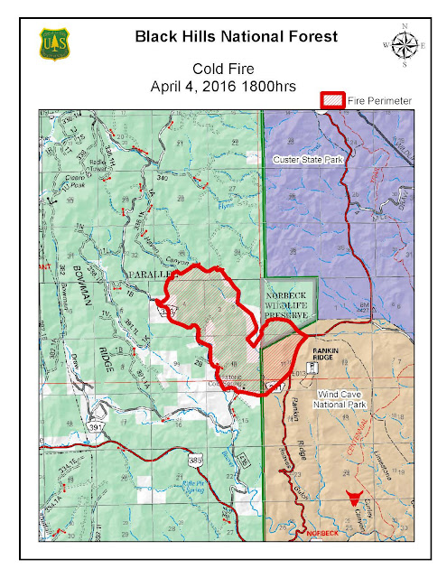
April 4, 2016 – 7:00 PM Update, Cold Fire Information: (605) 388-2309
Fire Information Hours - 8:00 am to 8:00 pm
Unless
there is significant activity, 2 updates will be posted, one after the morning
briefing and one after the evening briefing
Custer, SD – The Cold Fire remained at 1,900 acres in size, but is
now 30% contained. It has burned 1,258
acres on the Black Hills National Forest, 319 acres on Wind Cave National
Park, and 328 acres on private land.
154 personnel are
currently assigned to this fire. This includes 19 engines, three type 2 hand
crews (20 people each), 2 dozers, two type 1 helicopters, one type 3 helicopter,
and 1 fixed wing aircraft.
With the help of
milder weather and calmer winds, good progress was made on the fire today with
crews working to improve control lines and mop up, to ensure hot spots along
the perimeter are extinguished. Aerial
ignition was used to burn out on the north end to tie the active fire into control
lines.
Night resources
will focus on hot spots and patrolling in anticipation of strong winds in
excess of 50 + mph predicted to start late this evening and intensify throughout
the day tomorrow.
According to
Trevor Papenfuss, the Incident Commander Trainee, “We still have a lot of work
to do and this fire still has potential to grow. But firefighters have worked hard and have done
a great job of setting themselves up for tomorrow’s forecast. The fire could have easily become much larger
if it had not burned into areas that had recently been treated for fuels
reduction through prescribed burning and mechanical treatment.”
Along with aggressive suppression, objectives continue to be to provide
for firefighter and public safety, protect homes and subdivisions, protect Wind
Cave National Park infrastructure and natural resources, and protect wildlife
habitat and Custer State Park. No fire
fighter injuries have been reported.
An investigation
as to the cause is ongoing. No evacuations have been issued and no structures have been
lost.
Structure protection remains in place.
The Cold fire started on April 2, 2016, 4 miles east of Pringle, SD near
Highway 87.

Cold Fire Aerial Photo

A few photos from last night's firing operations (photos by Corey Jonas, Keystone Fire Department)


Photo: Night Firing ops, south side of fire, by Michael Engelhart, Black Hills National Forest

April
4, 2016 - 10:00 AM Update, Cold Fire Information: (605) 388-2309
Unless
there is significant activity, 2 updates will be posted, one after the morning
briefing and one after the evening briefing
Custer, SD – The Cold Fire is estimated at 1,900 acres in size, 20% contained, and has burned 1,258 acres on the Black Hills National Forest, 319 acres on Wind Cave National Park, and 328 acres on private land.
Custer, SD – The Cold Fire is estimated at 1,900 acres in size, 20% contained, and has burned 1,258 acres on the Black Hills National Forest, 319 acres on Wind Cave National Park, and 328 acres on private land.
200 personnel
are currently assigned to this fire. This includes 44 engines, three type 2
hand crews (20 people each), two type 1 helicopters, one type 3 helicopter, 2
fixed wings and 1 air tanker.
Today’s objectives are to provide for firefighter and public safety,
protect homes and subdivisions, protect Wind Cave National Park infrastructure
and natural resources, and protect wildlife habitat and Custer State Park.
Dry fuels, erratic winds, rough
terrain and low humidity remain a concern as firefighters and emergency
responders continue work to contain this fire. High winds tomorrow and spotting
activity also remain a concern.
The cause of the
fire remains under investigation. No
evacuations have been issued and no structures have been lost. Structure
protection remains in place.
Significant smoke may be visible as interior fuels continue to burn and
smolder. Custer, SD and surrounding area will be impacted by smoke due to south
winds.
Firefighters gained a significant advantage when the fire burned into the
'Section 2 Prescribed Burn Area. The recent prescribed burn provided fewer
fuels for the fire to consume and caused a significant decrease in fire
activity. Fuels treatment on private land also helped create defensible space.
The Cold fire started on April 2, 2016, 4 miles east of Pringle, SD near Highway 87.
The Cold fire started on April 2, 2016, 4 miles east of Pringle, SD near Highway 87.

Note: This is the last update today.
Information Hours: 8 a.m. –
9 p.m.
April 3, 2016 - 8:20 PM
Update, Cold Fire Information: (605) 388-2309
Cold
Fire Update
Custer, SD - Todays operations
on the Cold Fire have been successful in helping corral the Fire. The Cold Fire
is approximately 1300 acres and 10% contained.
200 personnel are currently
assigned to this fire. This includes 44 engines, three type 2 hand crews (20
people each), two type 1 helicopters, one type 3 helicopter, 2 fixed wings and
1 air tanker. More crews and equipment have been ordered and are enroute.
“There has been
considerable initial attack and suppression efforts from all of the cooperating
agencies on the Cold Fire,” said Black Hills National Forest Incident Commander
Matt Spring.
Rough terrain and strong erratic winds continue to be a challenge. There
are no evacuations and no structures have been lost.
Fire resources will continue to utilize direct and indirect line
construction, along with firing operations where necessary to implement a full
suppression strategy.
Resources will remain on the fire overnight and will continue to construct
indirect fire line in the northwest area of fire and if conditions permit,
prepare for firing operations.
Road closures remain in effect and include portions
of Highway 87, Flynn Creek Road to Glen Erin Road, the intersection of county
road 391 & FSR 435, south of cold springs school and Beaver Creek Road and
Bowman Ridge Road are closed to Highway 385. The public should contact the fire
information line for updated information on closures.
The cause of the fire remains under
investigation.
The Cold Fire is located approximately four miles east of Pringle, SD
burning primarily on the Black Hills National Forest, Wind Cave National
Park, Norbeck Wildlife Preserve and private land.
Correction: Rifle Pit Road is not closed. The intersection of county road 391 & FSR 435 is closed.
April 3, 2016 - 2:15 PM Update, Cold Fire Information: (605) 388-2309
Cold
Fire Update
Custer, SD - The Cold Fire, located 4 miles east of Pringle, SD near Highway 87, started on Saturday, April 2, 2016 and continues
to burn in rugged terrain. The fire is estimated at 1200 acres. The cause of
the fire is still under investigation.
Crews are continuing to improve containment
lines and are working to fully suppress the fire. Burnout operations last night
were very successful and beneficial. Despite gusty winds, crews continue to
gain ground. Smoke remains visible.
200 personnel are assigned to this fire. This
includes 44 engines, three type 2 hand crews (20 people each), four type 1
helicopters, one type 3 helicopter, 2 fixed wings and 1 air tanker. More crews
and equipment have been ordered and are en-route.
Air attack provided water drops throughout the
day to temporarily cool hot spots so firefighters could more safely and
effectively attack the fire.
Fire managers continue to work closely with
interagency cooperators from the local area and cooperative effort has been
excellent.
No evacuation orders are in place.
Current road closures include portions of Highway 87, Flynn Creek
Road to Glen Erin Road, and Beaver Creek Road and Bowman Ridge Road are closed to Highway 385. The public
should contact the fire information line for updated information on
closures.
An incident command post is established at the
old Custer Elementary School in Custer, SD.


Photos by Tracy Anderson, Black Hills National Forest


Photo by Jerry Krueger, Black Hills National Forest
###
Custer, SD – As of 8AM, the Cold Fire is estimated at 1,000 acres in size, burning on the Black Hills
National Forest, Wind Cave National Park, Norbeck Wildlife Preserve and private land.
Federal, State and local resources are working to contain the Cold Fire. An estimated 150 firefighters are on scene to include hand crews, fire engines, and overhead.
Today’s objectives are to provide for firefighter and public safety, protect homes and subdivisions, protect Wind Cave National Park infrastructure and natural resources, and protect wildlife habitat and Custer State Park. Fire managers are strategizing fire suppression tactics while monitoring fire behavior, the terrain, and weather forecasts.
Air resources have been ordered on this fire include an Air Attack platform, two National Guard Black Hawk helicopters, two Heavy Air Tankers, and one light helicopter.
The fire is currently not contained and the cause is under investigation. Current road closures include portions of Highway 87, Flynn Creek Road to Glen Erin Road, and Beaver Creek Road closed to Highway 385. (Please note correction: closed to Hwy 385 instead of Hwy 87). The public should contact the fire information line for updated information on closures.
No evacuations have been issued and no structures have been lost.
Engines were dispatched to a smoke report 4 miles east of Pringle, SD near Highway 87 on Saturday April 2, 2016 around 4:00PM. Due to high winds, the fire rapidly spread to the northeast and a Type III Incident Management team, led by Forest Service Incident Commander, Matt Spring was called in to manage the fire.
Dry fuels, erratic winds, rough terrain and low humidity are a concern as firefighters and emergency responders work to contain this fire.
Firefighters gained a significant advantage when the fire burned into the 'Section 2 Prescribed Burn Area,' that was burned approximately 18 months ago. The recent prescribed burn provided fewer fuels for the fire to consume and caused a significant decrease in fire activity.
Reminder: Open fires are prohibited in the Black Hills Fire Protection District on National Forest land
in South Dakota, except in designated recreational sites.

Update 11:15 PM - Please Note: This is the last update today.
Cold Fire Information: (605) 388-2309
Custer, SD - Federal, State and local resources are working to contain the Cold Fire.
Engines were dispatched to a smoke report 4 miles east
of Pringle, SD near Highway 87 on Saturday April
2, 2016 around 4:00PM. Due to high winds, the fire rapidly spread to the
northeast and a Type III Incident Management team, led by Forest Service Incident
Commander, Matt Spring was called in to manage the fire.
As of 10PM, the Cold Fire is estimated at 600
acres in size, burning on the Black Hills National Forest, Wind Cave National
Park, Norbeck Wildlife Preserve and private land.
The fire is currently not contained and the
cause is under investigation. Portions of Highway 87 and Beaver Creek
road are closed near the fire. No evacuations have been issued.
150 firefighters are on scene with an additional
250-300 expected Sunday as well as additional fire engines, air tankers and
helicopter aerial support.
Dry fuels, erratic winds and low humidity are
a concern as firefighters and emergency responders work to contain this fire.
Firefighters gained a significant advantage
when the fire burned into the 'Section 2 Prescribed Burn Area,' that was burned
approximately 18 months ago. The recent prescribed burn provided fewer fuels
for the fire to consume and caused a significant decrease in fire activity.
Black Hills National Forest Supervisor Craig Bobzien said, "We would
like to thank the public for their support and adjustments enabling firefighters
room to perform their jobs."
Fire managers are strategizing fire suppression tactics while monitoring
fire behavior, the terrain, and weather forecasts. Firefighter and public
safety are a primary concern.
Reminder: Open
fires are prohibited in the Black Hills Fire Protection District on National
Forest land in South Dakota, except in designated recreational sites.


Photo by Jerry Krueger, Black Hills National Forest

Photo by Tracy Anderson, Black Hills National Forest
Cold Fire burn out operations -photos by Brady Rothschadl


Updated at 8:30
* Cold Fire - Update at 8:30 P.M.
* Fire now full type-3. Incident management team ordered and enroute
* Fire made significant run - multiple structures were threatened, however protected by fire fighters and resources on scene
* Fire now 600 acres: including federal lands, Wind Cave National Park, Black Hills National Forest, Norbeck Wildlife Preserve and private land. Timber and grass fuels.
* 150 firefighters on scene with additional 250-300 expected in the morning as well as engines, air tankers and helicopter aerial support
* Significant advantage gained when fire burned into the 'Section 2 Prescribed Burn Area,' that was burned approximately 18 months ago - which provided significant decrease in fire activity
Cold Fire photos by Jim Strain.


*estimated size is now 200 acres
*Air resources have been ordered for tomorrow - TFR is in place
*Fire is burning in grass and timber
* Reported April 2, 2016 at 3:48 pm
* Located 4 miles east of Pringle, SD near Highway 87
* Federal jurisdiction - Forest Service Land - 75 acres
* Resources enroute - Federal, State and Local VFDs responding
* Cause Unknown at this time
Subscribe to:
Posts (Atom)