#1 - Prospect Fire
Reported: 4:15 pm, Mar 28, 2016
Location: on private .. off Deerfield Rd
Size: 2.24 acres
Resources: state and federal
Cause: Piles escaped
Contained as of 5:40 pm
#2 - Clydesdale Fire
Location on Private near Hart Ranch
Size: 1.8 acres
Resources: State
Cause: piles escaped
#3 - Not named yet
Location south of Whispering Pines VFD
Size: unknown
Resources: Fed, State & VFD enroute
Cause : unknown
Monday, March 28, 2016
Sunday, March 27, 2016
March 27 Wildfires
Incident #1 - Lame Johnny Fire
Reported: 3:30 pm
Located 2 miles NE of Windcave
Size: 50 acres
Resources : NENF and State Resources
Private
Cause: piles
Contained as of 9:15 pm, Mar 27
Incident #2 -Penial Fire
Reported: 4:52 pm
Located off Penial Valley Rd
Size: 2 acres
Resources: SD State Resources
Private
Cause: piles
Contained as of: 9:15 pm, Mar 27
Tuesday, March 22, 2016
Airport Fire
- Reported at 11:16 am 03/22/2016
- Located near Custer Airport; 2 miles South of Custer
- .3 acres on Forest Service Land
- Contolled as of 1:40 pm 3/22/2016
- Forest Service, VFD and State resources responded
- Cause: Powerline
Monday, March 21, 2016
BLM to Conduct Burn on Fort Meade Recreation Area
Update at 2:56 pm on March 21
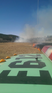 Photo credit: John Snyder
Photo of the Fort Meade North Prescribed Burn near Sturgis, SD.
Update at 1:14 PM on March 21
Posted at 11:06 AM on March 21
(BELLE FOURCHE, S.D.) --- The Bureau of Land Management (BLM) plans to conduct a 38 acre prescribed burn on the Fort Meade Recreation Area near Sturgis today.
Burning will only take place as weather conditions allow and when weather conditions are favorable. Burning operations will be completed in one day. Local authorities will be contacted by the BLM prior to any burning taking place.
This prescribed burn is planned for the north half of the Fort Meade Recreation Area, north of Highway 34 and east of the Muzzleloader Shooting Range. Smoke will likely be visible from State Highway 34, State Highway 79 and the city of Sturgis. Smoke will be monitored to minimize impacts to sensitive areas.
The prescribed burn is being conducted to reduce hazardous fuels accumulations, rejuvenate native plant species and to improve forage quality by reducing plant litter and decadent grass.
For additional information please call the South Dakota Field Office at 605-892-7000.

Photo of the Fort Meade North Prescribed Burn near Sturgis, SD.
Update at 1:14 PM on March 21
- Ignitions were completed at 12:35 PM on the prescribed burn at the Fort Meade Recreation Area.
- Objectives were met and the burn was a success.
Posted at 11:06 AM on March 21
(BELLE FOURCHE, S.D.) --- The Bureau of Land Management (BLM) plans to conduct a 38 acre prescribed burn on the Fort Meade Recreation Area near Sturgis today.
Burning will only take place as weather conditions allow and when weather conditions are favorable. Burning operations will be completed in one day. Local authorities will be contacted by the BLM prior to any burning taking place.
This prescribed burn is planned for the north half of the Fort Meade Recreation Area, north of Highway 34 and east of the Muzzleloader Shooting Range. Smoke will likely be visible from State Highway 34, State Highway 79 and the city of Sturgis. Smoke will be monitored to minimize impacts to sensitive areas.
The prescribed burn is being conducted to reduce hazardous fuels accumulations, rejuvenate native plant species and to improve forage quality by reducing plant litter and decadent grass.
For additional information please call the South Dakota Field Office at 605-892-7000.
Paha Sapa Fire
- Reported at 4:30 pm on 03/20/2016
- Located near Custer Crossing
- 5.6 acres, partially private and FS lands
- Contained on 03/20/2016 at 8:00pm
- Federal and State resources will continue to monitor today
- Human caused
Wednesday, March 16, 2016
Updated: Watertower Fire
Update: as of 6:00pm 3/16/16
The Water Tower fire adjacent to the State Vet’s home was controlled at around 2.6 acres. Fire is in the City of Hot Springs and the fire did burn on some state land. Photo of the State Vet’s home from the fire area is attached, along with a photo of Hot Brook Canyon on the fire edge to the north. Cause was unattended and illegal campfire.


Monday, March 14, 2016
JC Fire
- Located near the Nemo Job Corps
- 1/10 acre
- On Forest Service lands
- Forest Service resources responded
- Contained and Controlled as of 11:00 pm on 3/13/16
Sunday, March 13, 2016
Samelius Fire
- Located approximately 6 miles east of Hill City
- Estimated at 1/2 acre
- On Forest Service lands
- Federal and local resources are en route
- Cause is unkown
Friday, March 11, 2016
Ewoldt Road Fire
- Located 10 miles SE of Thedford, Nebraska
- Approximately 2 acres
- On private land
- Local and Federal resources responded
- Cause is unknown
Thursday, March 10, 2016
Little Elk Trailhead Fire
- Located approximately 2 miles west of Piedmont, SD near Dalton Lake
- 1/10 acre
- On Forest Service land
- Local and federal resources responded
Pleasant Valley Prescribed Burn
The South Dakota Department of Agriculture Wildland Fire Division and the South Dakota Game, Fish and Parks Wildlife Division will be conducting a prescribed burn on the Pleasant Valley Game Production Area on Thursday, March 10, 2016. This burn will take place four miles west and ten miles south of Custer.
Firefighters are planning on burning approximately 244 acres. This prescribed burn is being conducted to reduce pine regeneration and encroachment and to improve elk habitat. Smoke may be visible in the surrounding areas, and can linger for several days after ignition has been completed. Fire crews will secure, patrol and monitor fire lines as appropriate for public and firefighter safety.
Prescribed fire is utilized to maintain healthy native vegetation and is needed to prevent the encroachment of invasive species. Fire also reduces the hazardous buildup of debris and dead vegetation which can fuel wildfires.
Resources from SD Wildland Fire, SD Game, Fish and Parks, Custer State Park and the Black Hills National Forest will participate.
Saturday, March 5, 2016
Fuller Fire
-Located 5 miles east of Sundance on private land
-Estimated at 20 acres
-Burning in grass
-Local and federal resources responded, no additional resources have been ordered
Friday, March 4, 2016
Fire Update - Friday, March 4
Grey Goose Fire
- Located an estimated 7 miles north of Pierre
- Estimated size 1.4 acres
- Local and federal resources responded
- This fire has been controlled
Rifle Range Fire
- Located 5 miles northwest of Pierre
- Estimated size .1 acre
- Federal resources responded
- This fire is contained
Thursday, March 3, 2016
Dudley Fire
Fire update 9:40 AM on March 4
- An outbuilding was lost and damage to a mobile home occurred
- Fire activity has greatly decreased and firefighters are mopping up. The Incident Commander will start releasing resources within the hour.
- A Fire Investigator is currently on scene to determine cause.
Posted at 7:13 PM on March 3
- located north of Buffalo Gap
- Estimated size is 2 acres
- Volunteer Fire Department, State, and Federal resources responded
- Cause is under investigation
Subscribe to:
Posts (Atom)