Brass 2 Fire
Date Reported: December 28, 2024, 6:00am
Location: 4 miles WSW of Rockerville
Size: 0.1 acres
Resources Responded: Local
Cause: Human
Status: Out
Brass 2 Fire
Date Reported: December 28, 2024, 6:00am
Location: 4 miles WSW of Rockerville
Size: 0.1 acres
Resources Responded: Local
McGee Fire - Updated
Date Reported: December 19, 2024, 12:15am
Location: 5 miles SW of Rapid City, SD
Size: 46.2 acres
Resources Responded: Local, State, and Federal
Cause: Unknown
Status: as of 0800 Dec 20, 50% contained.
Gordon Fire
Date Reported: December 19, 2024, 3:31am
Location: 1 mile SW of Sheridan Lake
Size: 13.4 acres
Resources Responded: Local, State, and Federal
On 12/10/2024, South Dakota Wildland Fire will be conducting
a pile burn in the area of Elk Creek Road and Little Elk Creek Road near
Deadwood, SD 2 miles east of HWY 385.
Ignitions will begin the morning of Tuesday, 12/10/2024 and
may continue through Friday, 12/13/2024. The project is 4 acres of privately
owned forested property that was fuels reduced in the summer of 2022. There are
96 total hand piles on the project.
Possible areas of smoke impact are Elk Creek Rd, Little Elk
Creek Rd, and Coyote Ridge Rd.
Media Contact:
Scott Jacobson, Public Affairs Officer
(605) 440-1409
Custer, S.D., December 9, 2024 — With the recent snowfall across the Black Hills National Forest, Ranger Districts will begin burning thousands of hand and machine slash piles. Piles are created from timber sale slash and tree thinning operations.
Piles are only ignited when managers are confident that the project can be undertaken safely with considerations to snow cover, wind, temperature, available staffing, and smoke dispersal. Public and firefighter safety is always the number-one priority in all burning operations. Firefighters continually monitor and check the piles for several days after they have been lit.
“It is very important to reduce fire and insect hazards by reducing fuel buildup,” said Jason Virtue, Black Hills National Forest Fire Management Officer. “We appreciate the support from the communities. Being able to reduce these fuels this time of year makes fire suppression operations safer during the summer months.”
Smoke will be visible and may impact local communities across the Black Hills for the next several months. Smoldering material may continue to burn days after burning operations are completed.
For
more pile burning information and notifications, follow the Black Hills
National Forest on the Great Plains Fire Information page: http://gpfireinfo.blogspot.com/,
Facebook: https://www.facebook.com/blackhillsnf and/or Twitter: https://twitter.com/BlackHillsNF
For
more information on the Black Hills National Forest, visit www.fs.usda.gov/blackhills.
###
Marie Fire
Date Reported: December 7, 2024
Location: 1 mile N of Fort Pierre
Size: 1.0 acre
Resources Responded: State
Cause: Human
Current Status| Contained
Twin Lake Fire
Date Reported: December 7, 2024
Location: 9 Miles NW of Fort Pierre
Size: 0.10 acres
Resources Responded: Federal
Cause: Human
Current Status: Out
Blue Bell Fire
Date Reported: November 20, 2024
Location: Near Blue Bell Campground in Custer State Park
Size: 0.59 acres
Resources Responded: State, Local, and Federal
Cause: Human caused
Current Status: Forward Progress Stopped.
Mile Marker 20 Fire
Date Reported: November 21, 2024
Location: 2 miles NW of Whitewood, SD
Size: 0.25 acres
Resources Responded: Local, State, and Federal
Cause: Unknown
Current Status: Contained
The Bureau of Land Management plans to conduct a prescribed burn on the Fort Meade Recreation Area Thursday November 14, 2024. This 240-acre burn is planned near the Fort Meade Reservoir north of Highway 34. Smoke may be visible from Interstate 90, State Highway 34, State Highway 79, and the city of Sturgis. Burning will be completed in one day but smoke may be visible for multiple days after ignition is completed.
Prescribed fire projects require an extensive planning process to determine prescription parameters based off local knowledge, subject matter experts, as well as accepted scientific and computer-based modeling.
Burning will only take place when weather conditions are conducive to safe operations. Fire officials will monitor the current and forecasted weather to determine if conditions will remain favorable. The BLM will contact local authorities prior to any burning taking place.
Burn objectives are to reduce hazardous fuels accumulations, reduce ponderosa pine stand densities, and restore a more balanced pine-savanna habitat. Reducing plant litter, decadent grass, and fuel accumulations will also lower the likelihood or intensity of future wildfires in the area. Prescribed fire also encourages new growth in forage for wildlife and cattle, maintains many plant and animal species whose habitats depend on periodic fire, removes unwanted species that threaten species native to an ecosystem, and recycles nutrients back to the soil.
For additional information call the South Dakota Field Office at 605-892-7000.
For updates before, during, and after prescribed burning operations, you can follow us on Facebook at Bureau of Land Management – Montana/Dakotas or on Twitter @BLM_MTDKs.


Broadcast Burn Planned Southwest of Rapid City, SD
starting Thurs. Nov. 7, 2024
Rapid City, SD, Nov. 6, 2024 — If you see a
large plume of smoke in the air starting tomorrow, Thursday, Nov. 7, 2024,
southwest of Rapid City, SD, please do not call 911. Fire managers are
conducting a prescribed burn west of the junction of Victoria Lake and First
Thunder Roads.
The Mystic Ranger District on the Black
Hills National Forest is planning to ignite up to 250 acres on the Victoria
Project on Thursday and Friday, weather permitting.
The Victoria Project area is located
approximately 5 miles southwest of Rapid City, SD.
We are asking forest visitors,
recreational shooters, and hunters to consider using an alternate location on
the Forest during this time to ensure the safety of our firefighters and the
public.
Smoke from the prescribed burn will be
visible throughout the day of the burn and may linger for several days.
Firefighters will be on site throughout the day of ignition and will
periodically patrol the burn for several days afterward. If you see smoke from
this burn, please refrain from calling 911.
Broadcast burns are the application of
fire to the landscape under pre-determined environmental conditions and
geographic locations. Utilizing fire gives land managers another tool to meet
resource objects.
Crews have been preparing to implement the
project for several years.
The U.S. Forest Service conducts broadcast
burns in an effort of reducing hazardous fuels and to improve wildlife habitat
and forest health. Certain criteria must be met for a broadcast burn to
take place, including smoke dispersal conditions, weather, adequate staffing,
and fuel moisture. These are all outlined in a burn plan, that is thoroughly
reviewed before implementation.
Once completed, the burn area will also
serve to lessen fire intensities from naturally ignited fires such as lightning
and provide fire managers more options and increase safety when suppressing
future fires.
Forest visitors are asked to be aware of
their surroundings. Areas where burning operations are taking place will be
signed to notify visitors. The public is also encouraged to contact a nearby Forest
Service office with questions.
For more information on the Black Hills
National Forest, visit http://www.fs.usda.gov/blackhills.
###
USDA is an equal
opportunity provider, employer, and lender.
Englewood Fire
Reported: October 26th, 8:30 am
Location: Lawrence County, 3 miles S of Lead, SD
Size: 0.1 acres
Resources: State
Status: Out
Cause: Human
Rocky Fire
Reported: October 25th, 8:35 pm
Location: Custer County, 4 miles NNE of Custer, SD
Size: 0.1 acres
Resources: Federal, State
Status: Out
Cause:
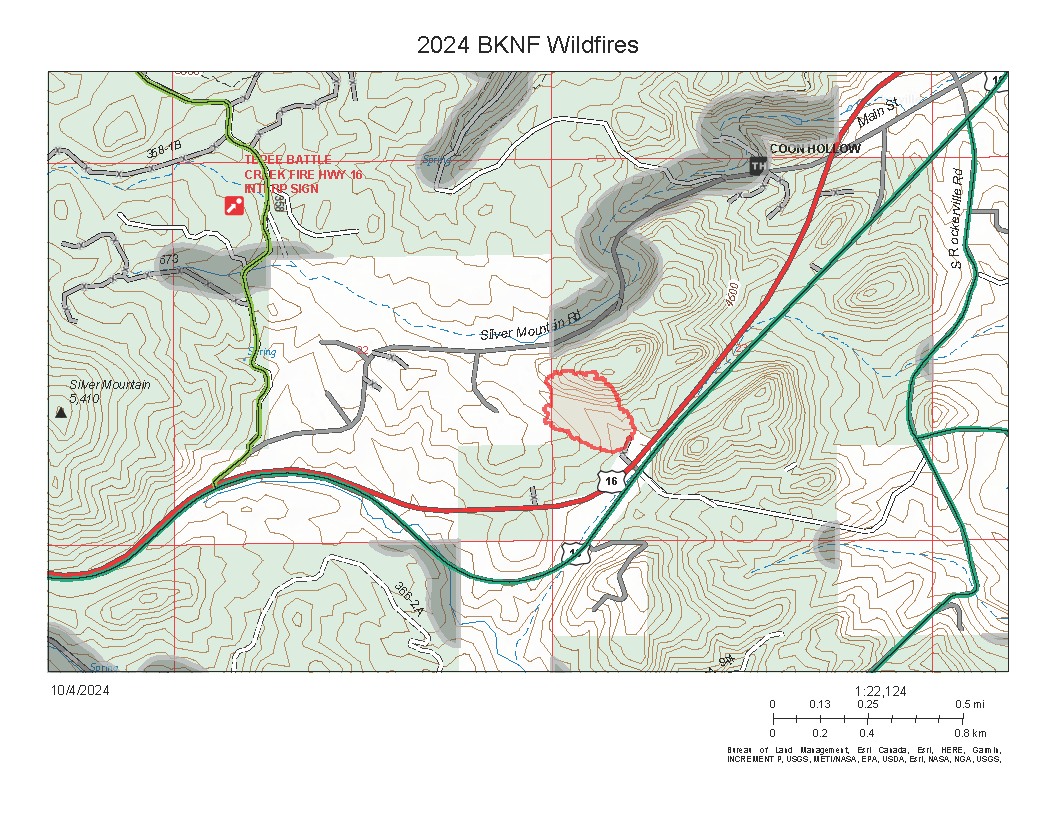
Old Highway Fire
Reported: October 24th, 2024 10:30 am
Location: 3 miles SW of Rockerville, at the intersection of Hwy 16 and Tepee Gulch Rd
Size: <0.1 acres
Resources: State
Status: Out
Cause: Human
Grace Fire
Reported: October 23rd, 2024 9:55 pm
Location: Custer State Park, 1 mile NW of the State Game Lodge
Size: 0.25
Resources: State
Status: Controlled
Cause: Human
Adelphia Fire
Reported: October 23rd, 2024 5:18 pm
Location: Lawrence County, 9 mi SW of Lead
Size: <0.1 acres
Resources: Federal, State, and Local
Status: Out
Cause: Human
Canvas Fire
Reported: October 16th, 3:22 pm
Location: 5.5 miles E of Piedmont, SD
Size: 0.1 acres
Resources: State, Local
Status: Out
Cause: Human
Axel Fire
Reported: October 15th, 2:26 pm
Location: Box Butte County, 19 miles NW of Hemingford, NE
Size: 86 acres
Resources: Federal
Status: Contained
Cause:
Kay Fire
Reported: October 14th, 1:26 pm
Location: 2 mi S of Dunning, NE
Size: 150 acres
Resources: Federal
Status: Contained
Cause:
Beagle Fire
Reported: October 13th, 4:01 pm
Location: South of Crawford, NE on East Belmont Road
Size: 20 acres
Resources: Federal and Local
Status: Contained
Cause: Human
Roosevelt Fire
Reported: October 12th, 8:44 pm
Location: 3 miles north of Lead, SD
Size: 0.1 acre
Resources: Federal, State, Local
Status: Out
Cause: Human
Witch Fire
Reported: October 11th, 8:36 pm
Location: 1 mile southwest of Pringle, SD
Size: 0.1 acre
Resources: Federal, State, Local
Status: Out
Cause: Human
Centennial Fire
Reported: October 10th, 10:22 pm
Location: 2 miles north of Sheridan Lake
Size: 3.6 acres
Resources: Federal, State, Local
Status: Controlled
Cause: Under Investigation
66
Reported: October 10th
Location: Pennington County, 5 miles N of Hermosa at mile marker 66
Size: 14.6 acres
Resources: State
Status: Contained
Cause: Human
Reno Fire
Reported: October 10th, 11:01 am
Location: Pennington County, 2 miles S of Hill City
Size: 0.1 acres
Resources: State
Status: Controlled
Cause: Human
Grier Fire
Reported: October 9th, 10:57 am
Location: Lawrence County, 1 mile W of Lead, SD
Size: 0.1 acres
Resources: State
Status: Out
Cause: Unknown
Tapper Fire
Reported: October 8th, 1:06 pm
Location: Crook County, 5 miles NW of Beulah, WY
Size: 0.1 acres
Status: Out
Cause: Unknown
Old Sawmill Fire
Reported: October 6th, 5:44 pm
Location: Off Old Sawmill Road north of Nemo, SD
Size: 0.1 acres
Resources: Federal, State, Local
Status: Out
Cause: Human
Cathedral Fire
UPDATE from Custer State Park (10-5-24)
We're Back Open!
Thanks to the incredible efforts of our wildland firefighters and local emergency management teams, the fire spread was kept to a small area.
As of October 5, 2024, the following areas are back open:
Please note that Little Devils Tower Trail will remain closed for the next several days. We ask visitors to please honor that closure and stay off the trail.
Thank you for everyone's understanding and support for Custer State Park.
Silica Mine Fire
Reported: October 5th, 10:01 am
Location: 4 miles southwest of Deerfield lake
Size: 0.1 acres
Resources: Federal
Status: Out
Cause: Human
Overnight, firefighters staffed and patrolled the line to ensure the fire did not cross the established boundary. Containment has been increased to 75% and the size remains at 22 acres.
Today, firefighters will continue to strengthen control lines and mop-up near the fire's edge. Mopping up makes a fire safer by extinguishing or removing burning and hazardous material within or close to the fire’s edge. Mop-up is hard, dirty, and tedious work that includes looking for smokes or hot spots in what otherwise looks like a cold area, and then extinguishing them.
Firefighters mop-up by dousing any remaining flames or embers and removing burning material near the control lines. They stir and drown any hot areas that are still smoking. Snags or trees may be felled because of fire inside their trunk or danger of falling. Logs may be trenched to prevent rolling, particularly rolling outside the fire control lines. This job requires firefighters to venture some 100-300 feet inside control lines to attack any remaining hot spots. This work starts as soon as possible after control lines are built and eventually progresses all the way around a fire’s perimeter. The fire is not out completely until mop-up is done and the fire’s outer edge is cold to the touch – firefighters literally feel the ashes with their bare hands to ensure all heat is gone. Mop-up can last for days after the last active flame along the control line has been extinguished. Stumps can burn for a long time. A single, undetected, burning ember could rekindle the fire and wipe out all previous firefighting efforts.
The National Weather US National Weather Service Rapid City South Dakota has issued a Red Flag Warning for today through Saturday. With winds 15 to 30 mph and gusts up to 45 mph this afternoon paired with minimum relative humidity 10-20%, we're urging the public to be extremely careful with all ignition sources.
Cathedral Fire
Reported: October 4th, 3:05 pm
Location: 6 Miles northwest of Custer, SD
Size: 0.45 acres
Resources: Federal, State, Local
Status: Contained
Cause: Unknown
For more information on closings at Custer State Park please contact Visitor Services Coordinator Lydia Austin at (406)291-7117
Black Hills National Forest
Forest Service News Release
Media Contact: Scott Jacobson, Public Affairs Officer
(605) 440-1409
scott.j.jacobson@usda.gov
Silver Mountain Fire Update
October 3, 2024 – The Silver Mountain
Fire was reported at 11:15am located approximately 1 mile west of Rockerville,
SD. The fire is currently estimated at 15-20 acres with federal, state, and
local firefighters responding. Multiple air resources are aiding ground crews
with suppression efforts to stop forward progression and establish a perimeter
around the fire. Firefighter and public safety continue to be a top priority.
Pennington County Emergency Management and the Pennington
County Sheriff’s Office have issued an official pre-evacuation notification to
residents impacted by the Silver Mountain Fire. Silver Mountain Road is
currently closed. Please avoid the area to allow firefighters to continue
suppression efforts.
Critical fire weather today continues to impact the Black
Hills area with temperatures in the 60s and low relative humidity. A fire
weather watch has been issued for tomorrow with breezy winds sustained at
10-20mph, and gusts up to 30mph expected. With continued critical fire weather
across the area, Forest officials are asking the public to be extremely careful
on the Forest with ignitions.
For more information, please visit the Silver Mountain Fire
Facebook page at: www.facebook.com/silvermountainfire2024/
Public safety information can be found at: https://www.facebook.com/RCPCEmgMgmt
###
USDA is an equal opportunity provider, employer, and
lender.
Song Fire
Reported: October 3rd, 3:03 pm
Location: 5 Miles northwest of Hot Springs, SD
Size: 0.25 acres
Resources: Federal, State, Local
Land Ownership: Private
Status: Contained
Cause: Under Investigation
Silver Mountain Fire
Location: Approximately 1 mile southwest of Rockerville, SD near Silver Mountain Road
Size: 15-20 acres
Resources: Federal, State, Local
Land Ownership: Forest Service
Status:
Cause: Under Investigation
For more information about the fire, follow our Facebook page at: https://www.facebook.com/silvermountainfire2024/
or contact us at: (605)390-2057
144 Fire
Reported: September 30th, 5:41 pmLocation: North of Nemo, SD
Size: 0.1 acres
Resources: Federal, State, Local
Status: Controlled
Cause: Human
October Fire
Reported: September 29th, 4:44 pmLocation: 15 miles SW of Chadron, NE
Size: 275 acres
Resources: Federal, State, Local
Status: Contained
Cause: Unknown
Homestake Fire
Reported: September 29th 8:54 am
Location: 5 miles west of Spearfish
Size: 0.1 acre
Resources: State
Status: Out
Cause: Unknown
Lytle Hill Fire
Reported: September 28, 2024 10:43PM
Location: Crook County, 12 Miles South of Beulah
Size: 11 acres
Resources: Federal
Status: Contained
Cause: Unknown
Short Grass Fire
Reported: September 26, 2024 03:43PM
Location: Approximately 2 miles Southwest of Fairburn
Size: 3.6 acres
Resources: Federal/State/County
Status: Out
Cause: Unknown
Slate Creek Fire
Reported: September 26, 2024 02:29PM
Location: Approximately 4 miles Southeast of Deerfield Lake
Size: .1 acre
Resources: Federal/State
Status: Out
Cause: Human
Solomon Fire
Reported: September 26, 2024 01:40PM
Location: Approximately 2 miles West of Rochford Cemetery
Size: .1 acre
Resources: Federal
Status: Controlled
Cause: Human
Bowman Fire
Reported: September 26, 2024 12:05PM
Location: Custer County, 1 mile NE of Pringle
Size: .25 acres
Resources: Federal/State
Status: Controlled
Cause: Unknown
Gulch Fire
Reported:
September 26, 2024 10:56AM
Location: Higgins Gulch Area. 6 Miles West of Spearfish, SD
Size: .1 acre
Resources:
Federal
Status: Controlled
Cause: Abandoned Campfire
Bronco Fire
FOR IMMEDIATE RELEASE
Contact:
Tim Buskirk, (308) 432-0393, US Forest Service
Katrina Cerveny (402) 326-3179, Nebraska Emergency Management Agency
8:30 am. Bronco Fire Update
September 21, 2024 (CRAWFORD, NEB.) - Firefighters made good progress toward containment of the Bronco Fire near Crawford, NE today. The Bronco Fire is currently 72% contained and 1,060 acres.
Crawford Volunteer Fire Department, Nebraska Emergency Management Agency, and the US Forest Service would like to thank the entire community for their support.
“Thank you to all the firefighters who worked safely to contain this fire. We appreciate the support of the community,” said incident commander Nathan Flowers. “We ask the public to please continue to stay off the roads in the fire area.”
Governor Jim Pillen verbally authorized a disaster declaration which will be followed by a written Governor’s disaster proclamation. The public is asked not to travel on any roads nearby for their own safety and the safety of firefighters. No unnecessary travel on Milo Road, Sand Creek Road and Cottonwood Road.
Please note, this will be the last regularly scheduled press release from the Bronco Fire. Please see Crawford Volunteer Fire Department and/or the Nebraska National Forests and Grasslands Facebook pages for further information.
Bronco Fire
FOR IMMEDIATE RELEASE
Contact:
Tim Buskirk, (308) 432-0393, US Forest Service
Katrina Cerveny (402) 326-3179, Nebraska Emergency Management Agency
9:30 a.m. Bronco Fire Update
September 20, 2024 (CRAWFORD, NEB.) - Firefighters continue to battle the Bronco Fire, located 11 miles northwest of Crawford, Nebraska in Sioux County. Federal, State and Local resources assigned to the fire include 125 personnel and multiple air resources. Rough terrain combined with hot and dry weather conditions continue to challenge firefighters.
The fire is currently at 915 acres and is not contained. Additional ground crews arrived last night and will continue to work towards containment of the fire by constructing fire lines today. Governor Jim Pillen verbally authorized a disaster declaration which will be followed by a written Governor’s disaster proclamation.
The fire is managed under a unified command between Crawford Volunteer Fire Department, Nebraska Emergency Management Agency, and the US Forest Service. Fire management transitioned to a Type 3 organization last night to best support firefighters and other resources.
Hot and dry weather will continue today. Wind conditions are favorable, and the outlook is for cooler weather over the weekend.
The public is being asked not to travel on any roads nearby for their own safety and the safety of firefighters. No unnecessary travel on Milo Road, Sand Creek Road and Cottonwood Road.
.jpg)