Tuesday, November 29, 2016

Pile Burning to Start in the Black Hills National Forest

Fire Crews Burn Piles across the Black Hills National Forest

Spearfish, SD; November 29, 2016 – Forest Managers are working to reduce hazardous fuels across the Black Hills National Forest.

Starting today & continuing through the week into next week, Northern Hills fire will be burning piles located South of Aspen Hills Rd, East of Forest Service Road (FSR) 134.1, North of 222.2 and off of FSR 207, west of Rochford Rd.

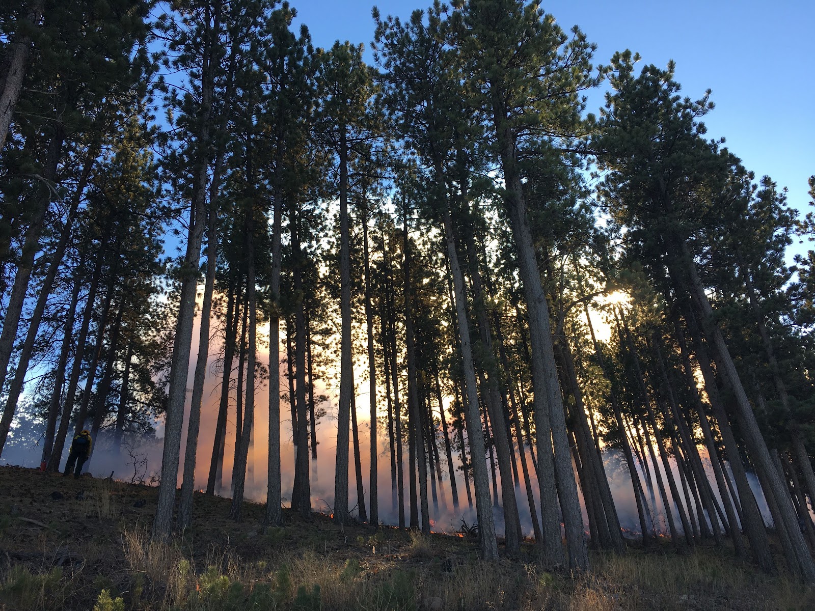
Throughout the winter, Districts across the Black Hills National Forest are focusing efforts on burning hand and machine slash piles. Piles are created from timber sale slash and tree thinning operations.

“It is very important to reduce fire and insect hazards by reducing fuel buildup,” said Todd Pechota, Black Hills National Forest Fire Management Officer. “With today’s snowfall in the northern hills and extended forecast, conditions are good for reducing these forest fuels through pile burning.”

Smoke will be visible and may impact local communities across the Black Hills for the next several months. Smoldering material may continue to burn days after burning operations are completed. Crews will continue to burn as conditions permit. Firefighters continually monitor and check the piles for several days after they have been lit.

“We appreciate the support from the communities,” said Pechota. “Being able to reduce these fuels this time of year makes fire suppression operations safer during the summer months.” 

Burning operations will continue throughout the winter as conditions permit.

For more pile burning information and notifications, follow the Black Hills National Forest on Facebook: https://www.facebook.com/blackhillsnf or Twitter: https://twitter.com/BlackHillsNF

For more information on the Black Hills National Forest, visit http://www.fs.usda.gov/blackhills.

-USDA-

USDA is an equal opportunity provider, employer, and lender.

Wednesday, November 16, 2016

Silver Mountain Prescribed Fire A Success

Rapid City, SD; November 16, 2016 – 209 acres were successfully ignited yesterday, November 15, 2016, on the Black Hills National Forest Silver Mountain prescribed fire. 

The Silver Mountain project area is located approximately 10 miles west/southwest of Rapid City, SD between Highway 16 and Sheridan Lake Road, along Boulder Hill Road to the west.

The prescribed fire was effective in breaking up the continuity of dead, downed fuels which will lessen the severity and extent of future wildfires in the project area. The fire will also benefit wildlife habitat and create a more adaptive fire ecosystem.

Typically, the Forest Service will only burn when the smoke dispersal rating is fair or better. A rating of fair or better allows smoke to rise higher in the atmosphere and allows upper air winds to disperse smoke. Officials said smoke dispersal was very good yesterday resulting in light smoke impacts.

Ignition will not continue today, however, resources will remain on scene to extinguish burning and smoldering material near fire lines.

The Silver Mountain prescribed fire was conducted in the area of the Battle Creek Fire that occurred in 2002.

For more information on Black Hills National Forest prescribed fire, visit http://www.fs.usda.gov/detail/blackhills/landmanagement/resourcemanagement/?cid=STELPRDB5112694

Monday, November 14, 2016

Silver Mountain Prescribed Fire

November 15, 2016

3:25 p.m. - Photos of the Silver Mountain prescribed fire are posted at: https://www.facebook.com/pg/blackhillsnf/photos/?tab=album&album_id=1705642313029698


2:40 p.m. - 70% ignition complete of the 209 acres planned for today.

10:30 a.m. - After a successful test burn, ignition has begun on the Silver Mountain prescribed fire.

November 14, 2016 – The Mystic Ranger District on the Black Hills National Forest is planning to ignite 221 acres on the Silver Mountain project Tuesday, November 15 & Wednesday, November 16, depending on weather. Smoke will be visible for several miles and could impact Highway 16, Hill City, Rapid City and other surrounding areas. Crews have been preparing to implement the project to meet management objectives for several years.

The Silver Mountain project area is located approximately 10 miles west/southwest of Rapid City, SD between Highway 16 and Sheridan Lake Road, along Boulder Hill Road to the west.

The goal of the Silver Mountain Prescribed Fire is to maintain a mosaic of vegetation conditions created by the Battle Creek Fire of 2002. This project will lessen the severity and extent of future wildfires in the project area by breaking up the continuity of dead, downed fuels, ultimately reducing those fuel loads. Fire will also be utilized as a tool to thin pine regeneration and increase canopy base heights. Additionally, this burn will stimulate browse for big game species.

After many years of fire exclusion, an ecosystem, such as the Black Hills, needs periodic fire to remain healthy. Without it, trees are stressed by overcrowding, fire-dependent species disappear, and flammable fuels build up and become hazardous.

Forest visitors, including hunters, are asked to be aware of their surroundings and watch for prescribed burning operations in the months ahead. Areas where burning operations are taking place will be signed to notify visitors. The public is also encouraged to contact a nearby Forest Service office with questions.

As conditions permit, fire officials will continue to assess ignition of other prescribed burn units across the Black Hills National Forest.

For more information on Black Hills National Forest prescribed fire, visit http://www.fs.usda.gov/detail/blackhills/landmanagement/resourcemanagement/?cid=STELPRDB5112694


Thursday, November 10, 2016

211 Helpline Center and Great Plains Fire Information Partner on Area Fire Alert Messaging

Subscribe by texting 'GPFire' to 898211

Rapid City, SD
- Great Plains Fire Information, comprised of the Black Hills National Forest, Nebraska National Forest and Grasslands and South Dakota Wildland Fire Division, is partnering with the 211 Helpline Center to notify the public of significant fire activity within the Great Plains geographical area (Black Hills and surrounding areas) using text messaging.

To subscribe, text ‘GPFire’ to 898211. Text ‘STOP’ to cancel at any time.

Notification text will be sent to those who subscribe on significant fire activity, including wildland and prescribed fires within the Great Plains Dispatch Zone.

“We are always looking for ways to improve communications during a wildland fire or prescribed fire that may draw interest due to its location, size and/or impacts it’s having on a community,” said Scott Jacobson, Black Hills National Forest Public Affairs Officer. “Almost everyone has a phone that can receive a text and this gives us another avenue we can reach people with critical fire alerts and messaging.”

Fire officials partnered with 211 to use this texting feature during the Crow Peak fire that occurred near Spearfish, SD last summer. “We had great success in keeping the public informed on the status of the fire and area closures,” said Brenda Bowen, Crow Peak Fire Public Information Officer.

Public Information Officers (PIOs) from Federal and State agencies continue to work together to distribute information about initial attack fires within the Great Plains initial attack zone. Along with this new texting feature, area fire information can be obtained via one common phone number, e-mail, blog, and Twitter account.

Great Plains Fire Information/PIO Contact Information:

Monday, November 7, 2016

Work Center Prescribed Burn

Work Center Prescribed Fire Photos: https://www.facebook.com/blackhillsnf/photos/?tab=album&album_id=1702067523387177


Ignitions have been completed on the Work Center prescribed fire today. Crews successfully burned 30 acres in one unit.

The burn plan parameters were on the low end of the prescription and fire officials decided to focus on completing one smaller unit. They will look at burning more units at a later date as conditions permit.

11:45 a.m. - Ignitions on the Work Center RX are 75% complete.

BloggerImage

BloggerImage


The North Zone Fire Program on the Black Hills National Forest has successfully completed a test burn & are proceeding with the Work Center Prescribed Fire Project  today, Monday, November 7, 2016. 

The Work Center Project is about one mile southwest of the City of Spearfish, South Dakota, off of Forest Service road 134, (Tinton Road). Smoke will be visible from the City of Spearfish and Interstate 90. Areas of smoke will be more noticeable in the evening and in the morning after the completion of the prescribed burn and could reach portions of neighborhoods within Spearfish City Limits.

Sunday, November 6, 2016

November 6th, 2015

Mahto Fire
  • Reported:  14:24 pm
  • Location: North Side of Bear Butte
  • Size:  37 acres
  • State & Local resources on scene
  • Cause: Human


Y4 Fire
  • Reported:  9:13 am
  • Location: Pass Creek Road, Custer County
  • Size:  1/10 acre
  • Cause: Human - Illegal Campfire
  • Out

Long Draw Prescribed Burn

Originally ignited November 1st.  
Located approximately 5 miles south west of Hill City, SD near Newton Fork Road, south of Reno Gulch road, Odakota Mountain and west of the Medicine Mountain Boy Scout Camp.

Smoke was visible today as pockets of unburned fuels in the interior continue to burn. Crews remain on scene monitoring the fire.

The goal of the Long Draw Prescribed Fire is to establish and maintain a mosaic of vegetation conditions over the project area. This project will lessen the severity and extent of future wildfires in the project area by breaking up the continuity of dead, downed fuels, ultimately reducing fuel loads. Fire will also be utilized as a tool to thin pine regeneration and increase canopy base heights. Additionally, the burn will stimulate browse for big game species.

Work Center Prescribed Burn
  • About one mile southwest of the City of Spearfish, South Dakota, off of Forest Service road 134, (Tinton Road). Smoke will be visible from the City of Spearfish and Interstate 90. 
  • Planned ignition November 7th if burning conditions are within prescription.


Saturday, November 5, 2016

November 5th, 2016. 10:45 am

Johnson Fire - UPDATE
  • Reported:  17:45 pm. November 4th
  • Location: Beretta Road on Black Hills National Forest
  • Size:  12 acres
  • Federal, Local & State resources on scene
  • Cause: Under Investigation
  • 100% Contained.  Crews mopping up.

Friday, November 4, 2016

Prescribed Fire Planned in Northern Black Hills

Spearfish, SD, November 4, 2016 – Forest Officials from the North Zone Fire Program on the Black Hills National Forest are planning to burn approximately 225 acres on the Work Center Prescribed Fire Project as early as Monday, November, 7. North Zone Fire Program is also planning to burn approximately 133 acres on the Burner Prescribed Fire Project next week.

The Work Center Project is about one mile southwest of the City of Spearfish, South Dakota, off of Forest Service road 134, (Tinton Road). Smoke will be visible from the City of Spearfish and Interstate 90. Areas of smoke will be more noticeable in the evening and in the morning after the completion of the prescribed burn and could reach portions of neighborhoods within Spearfish City Limits.

The Burner Project is approximately three miles northwest of Sundance, WY off of Forest Service road 838, (Warren Peak Hwy). Smoke will be visible from Sundance and Interstate 90. Areas of smoke will be more noticeable in the evening and in the morning after the completion of the prescribed burn and could reach portions of neighborhoods within Sundance City Limits.

Fuel moistures and weather conditions such as temperature and wind direction will be a contributing factor for determining which project Fire Officials will implement first, as well as deciding which day next week to conduct the burn project. Objectives of the burn are to reduce surface and ladder fuels that contribute to crown fire hazard. The reduction of excess hazardous fuels provides additional protection to nearby homes, while also providing fire managers safe and effective areas in which to manage future wildland fires. Additional goals include providing for diverse ecosystems, improving sensitive plant habitats within the unit, and to promote foraging opportunities for animals.

Prescribed Fire Specialists compare conditions on the ground to those outlined in burn plans before deciding whether to burn on a given day. A prescribed burn will not be ignited unless the conditions meet the criteria described in the burn plan. Resources will continue to monitor the prescribed burn through the week, and until declared out.

The Parking Lots and Trailheads for the Tinton Trail system will be temporarily closed the day of the burn for use by fire officials. The Tinton Trail will remain open. Officials ask recreationalists to find parking outside of the trailheads and prescribed fire project area.

Forest visitors, including hunters, are asked to be aware of their surroundings and watch for prescribed burning operations in the months ahead. Traffic control on Forest Service roads during implementation, may be in place to provide safety to visitors who are passing through the burn area. Areas where burning operations are taking place will be signed to notify visitors. The public is also encouraged to contact a nearby Forest Service Ranger District office with questions.

As conditions permit, fire officials will continue to assess ignition of other prescribed burn units across the Black Hills National Forest.


For more information on Black Hills National Forest prescribed fire, visit http://www.fs.usda.gov/detail/blackhills/landmanagement/resourcemanagement/?cid=STELPRDB5112694

November 4th, 2016 - Updated at 5:45

Reuter Fire

  • Reported:  16:46 pm
  • Location: North of Sundance on Black Hlls National Forest along Warren Peak Highway
  • Size: 1/10  acre
  • Contained, Controlled, Out
  • Cause: Human
Johnson Fire
  • Reported:  17:45 pm
  • Location: Beretta Road on Black Hills National Forest
  • Size:  Estimated 8-10 acres
  • Federal, Local & State resources on scene
  • Cause: Under Investigation
  • Firefighters have stopped the forward progress; suppression is also being aided by the fire burning into the 2008 Bitter Prescribed Burn.
Calumet Fire
  • Reported:  12:38 pm
  • Location: 2 miles south of Sheridan Lake on Black Hills National Forest
  • Size:  .85  acre
  • Federal, Local & State resources on scene
  • Cause: Under Investigation

Thursday, November 3, 2016

Lagoon Fire Nearing Completion

The Lagoon Prescribed Fire near Chadron, Nebraska is nearing completion.  Ignitions around the fire perimeter are complete, and approximately 26 fire personnel remain on site to monitor fire activity and to mop up any interior hot spots. Smoke may remain visible through tomorrow afternoon near Pine Ridge Job Corps.

The 20-acre prescribed fire has decreased vegetation near the inlet and outlet pipes of the Pine Ridge Job Corps Center’s wastewater lagoon, preventing root damage to the underground liner that protects the soil from contamination from the lagoon's water.

For more information about this or other local prescribed fires, please contact the U.S. Forest Service, Pine Ridge Ranger District office at 125 North Main in Chadron or by phone at 308-432-0300.


Wednesday, November 2, 2016

Small Fire Update: Wednesday, 11-2-2016

Wednesday, 11-2-2016

MM 115 Fire
  • Size: .1 acre
  • Location: Eastbound Mile Marker 115, Interstate-90 near Wall, SD
  • Contained @ 2:35 p.m.
  • Cause: human
  • Local VFD and Federal resources responded.

Lagoon Prescribed Fire Planned for Thursday near Chadron

The Pine Ridge Ranger District of the Nebraska National Forests and Grasslands plans to burn approximately 20 acres on Thursday, November 3.  The Lagoon Prescribed Fire unit is located approximately 10 miles south of Chadron, Nebraska, east of Highway 385, behind the Pine Ridge Job Corps Center.

“The primary purpose of the Lagoon Prescribed Fire is to decrease vegetation near the inlet and outlet pipes of the Pine Ridge Job Corps Center’s wastewater lagoon. Reducing the vegetation will also decrease root damage to the underground liner that protects the soil from contamination from this water.” said Michael Mattmiller, Acting District Fire Management Officer.

Smoke may be visible from Highway 385 and 20 and from the communities of Chadron, Hay Springs, and Crawford.  Access may be limited on the Job Corps By-Pass Road (FS 775) for a short amount of time if smoke becomes an issue.

Please see below for a map of the planned fire's location.  Paper maps of the burn area are available at the Pine Ridge Ranger District office at 125 North Main in Chadron.  The public is encouraged to stop by that office or call 308-432-0300 if they have questions.


Tuesday, November 1, 2016

Applee Tree Prescribed Fire Planned November 2 & 3 in Custer State Park

The South Dakota Department of Agriculture’s Wildland Fire Division, Custer State Park and South Dakota Game, Fish and Parks are planning to ignite the Apple Tree prescribed fire on Wednesday, Nov. 2. Ignition will continue Thursday, Nov. 3, as conditions allow.

Firefighters are planning on burning approximately 624 acres. This project is located in Custer State Park, off of the southern end of the Wildlife Loop Road.

This interagency prescribed fire is a cooperative effort with grant funding provided by the Rocky Mountain Elk Foundation. This grant funding helps meet land management objectives that otherwise could not have been accomplished due to budget constraints.

Objectives of the burn are to improve wildlife habitat, provide quality forage and reduce hazardous fuels in an effort to create and maintain a forested landscape that inhibits the spread of unwanted fire to the crowns of trees. Weather conditions will be monitored closely to ensure prescribed fire conditions align with management objectives for the burn.

Prescribed fire is used to maintain healthy native vegetation and is needed to prevent the encroachment of invasive species. Fire also reduces the hazardous buildup of debris and dead vegetation which can fuel wildfires.


Smoke may be visible in the surrounding areas, and can linger for several days after ignition has been completed. Fire crews will secure, patrol and monitor fire lines as appropriate for public and firefighter safety. For more information on smoke management visit:  http://gpfireinfo.blogspot.com/p/smoke-management.html