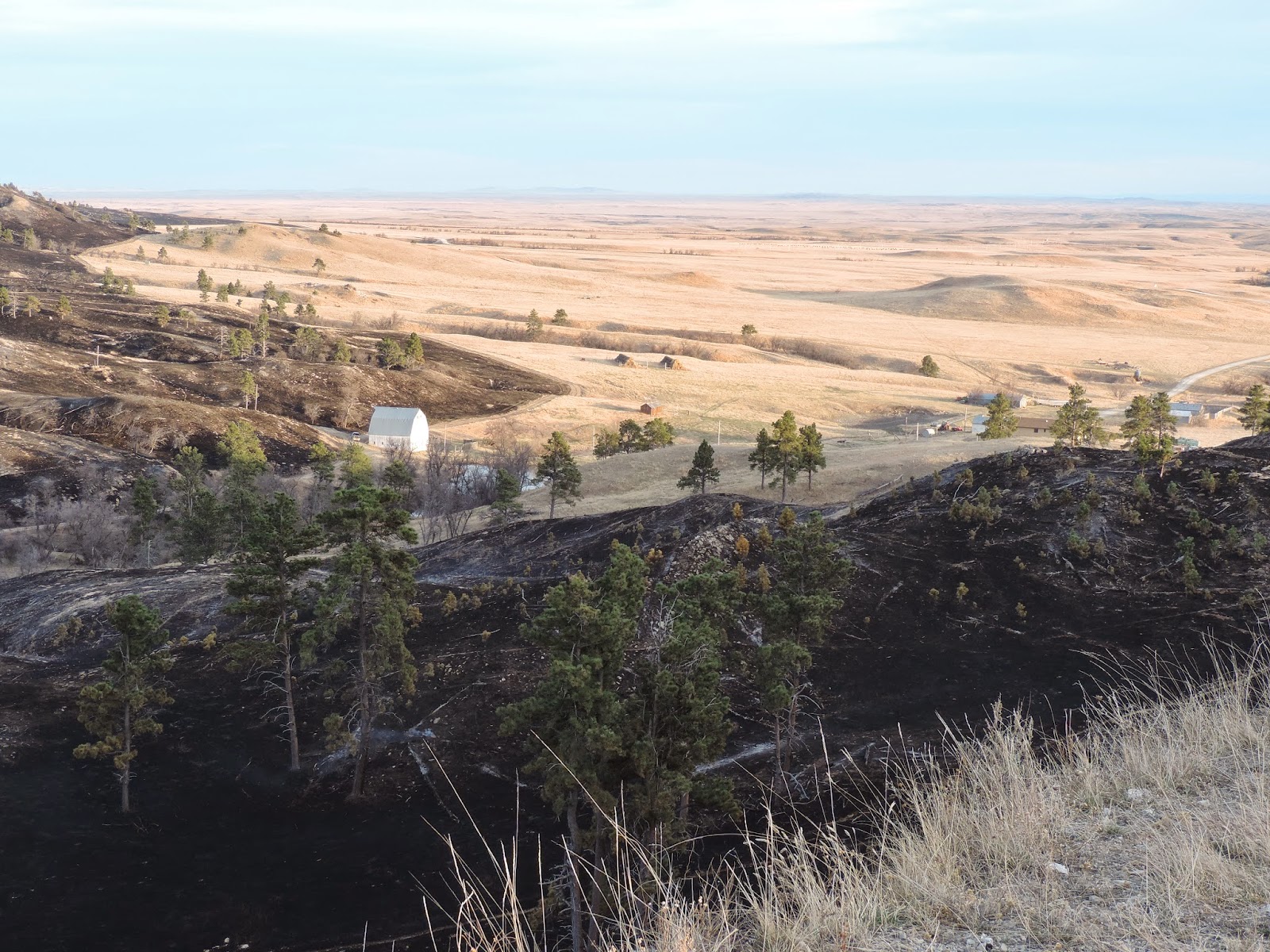
- Located on private land approximately 6 miles west of Hermosa.
- Estimated size is 5 acres.
- Hermosa and Hayward VFD on scene and Forest Service is enroute.
- Human Caused (escaped burn piles).
Saturday, December 19, 2015
Ghost Canyon
December 19, 2015 at 4:15 pm
Wednesday, December 9, 2015
Rock Chimney
Update December 9, 2015 at 3:15 pm
- Fire is 100% contained.
December 9, 2015 2:51 pm
- Located on private land approximately 1 mile south of Custer.
- Estimated size is 0.40 acres.
- State and Local resources are on scene.
- Human Caused (escaped burn piles).
Canyon
December 9, 2015
- Located on private land approximately 4 miles west of Blackhawk off of Nemo Road.
- Estimated size is 0.25 acres.
- State and Local resources are on scene.
- Human Caused (escaped burn piles).
- Fire is 100% contained.
Sunday, December 6, 2015
Playhouse
Update December 7, 2015 at 8:45 am
December 6, 2015 at 2:30 pm
- Contained on December 6, 2016 at 4:27 pm.
- Size 1 acre
- Firefighters will continue to mop-up today and work towards control.
December 6, 2015 at 2:30 pm
- Located on private land approximately 1.5 miles NE of Lakota Lake or 3 miles SE of Keystone.
- Reported at 11:54 am.
- Current estimated size is 1 acre.
- Local and State resources have responded, and a hand crew has been ordered.
- Human caused (escaped burn piles).
Friday, December 4, 2015
December 4, 2015
Pile burning west of Custer, SD near Lightning Creek Road.
Forest Service is on scene.
Fire activity is within the parameters identified for burning the piles.
Wednesday, November 18, 2015
Argyle Road Fire
Updated at 3:45
Estimated at 90% contained. Full containment expected in the next few hours.
Estimated containment at 20%
Updated on November 18 at 11:23 am
- Located approximately 1 mile south of Argyle, SD
- Estimated size is 5 acres
- Burning in grass and timber
- Local (VFD), State, and Federal resources are responding to include engines, hand crews, and a skid loader
- Structures are threatened
- Cause is under investigation
Monday, November 16, 2015
Black Forest Fire
Posted at 9:00 am on November 16th
- Located 3 miles south of Pactola Lake
- Estimated size is .3 acres
- Local, state, and federal resources responded
- A fire investigator will be on scene today
Wednesday, October 21, 2015
Quaal Road Fire
Updated at 5:50 pm
Size is 5.75 acres
Updated at 2:45 pm on October 21
- Size is now estimated at 5 acres
- Fire is burning in grass and timber
 |
| Quaal Fire - Photo taken by Callia Scott |
Posted at 2:09 pm on October 21
- Located north of I-90 at mile marker 50 in Pennington County
- Estimated size is 3 acres
- Local, state, and federal resources are responding
- Cause is unknown
 |
| Quaal Fire - Photo taken by Kyle Huling |
Sunday, October 18, 2015
Nail Fire
-located southeast of Ft. Pierre near the Ft. Pierre National Grasslands on private land
-Estimated size is 29 acres
-local volunteer fire departments and a federal engine responded
-Cause is unknown
Baker Park Fire
Update as of October 19 at 10:20 am
-Baker Fire has been contained at 3.6 acres
-Located off of Highway 16 and Beretta Road
-Baker Fire has been contained at 3.6 acres
-Located off of Highway 16 and Beretta Road
-Estimated size is 3 acres
-Rockerville, Whispering Pines, and Keystone Volunteer Fire Departments have responded along with state and federal engines
-Law Enforcement is on scene, cause is under investigation
Friday, October 2, 2015
Fire Update - October 2, 2015
A thunderstorm has moved through the area the past few hours and lit up some wildfires with
lightning strikes. Resources have responded to all listed incidents.
Keyhole Dam Fire
- Located in Crook County, Wyoming
- Estimated size .1 acres
Long Branch Fire
- Located near Sugar Loaf Butte in the Oglala National Grasslands in Nebraska
- Estimated size is 6.55 acres
Muddy Fire
- Located in the Mud Springs Road area in Custer County
- Estimated size is .1 acre
Tlustos Fire
- Located in the West Black Banks area in Fall River County
- Estimated size is 80 acres
McKenna Fire
- Located off of Hell Canyon Road in Custer County
- Estimated size is .1 acre
Incident #6
- Located approximately 1 mile north of Pilger Mountain in Fall River County
- Size up is currently in progress
Updated information can also be found by checking Great Plains Dispatch WildWeb page at: http://www.wildcad.net/WCSD-GPC.htm
Wednesday, September 30, 2015
Stagebarn Fire
-Located an estimated 5 miles west of Black Hawk on the Black Hills National Forest
-Estimated size is 2 acres
-Resources are on scene include volunteer fire departments, state and federal engines, and the state Bear Mountain Hand Crew
-Cause is unknown, a Fire Investigator is on scene
-Plans include overnight staffing
Monday, September 28, 2015
Hood Fire
- Located near Sylvan Lake in Custer State Park
- .1 acre
- Caused by lightning
- Resources responded
Sunday, September 27, 2015
Woodville Wildfire
Location: Lawrence County Quarry .. exemption area - BLM.
Reported at: 12:32 pm
Size: .1 acre
Cause: under investigation
Resources Responded.
Reported at: 12:32 pm
Size: .1 acre
Cause: under investigation
Resources Responded.
Tuesday, September 15, 2015
Lone Tree Fire
Location: 5 miles north of Whitney, NE
Size: 1788 acres
Resources: Nebraska NF, SD wildland fire, Nebraska VFD's
Contained at 1430 hrs
Cause: round baler on private in hay field.
Size: 1788 acres
Resources: Nebraska NF, SD wildland fire, Nebraska VFD's
Contained at 1430 hrs
Cause: round baler on private in hay field.
Saturday, September 12, 2015
Baldy Fire
Baldy Fire
Location: in Lawrence County, west of iron Creek Lake and Old Baldy Road
Reported at: 12:20 pm
Size: .10 acre
Cause: Unkown
Resources Responded. Fire is contained
Location: in Lawrence County, west of iron Creek Lake and Old Baldy Road
Reported at: 12:20 pm
Size: .10 acre
Cause: Unkown
Resources Responded. Fire is contained
Thursday, September 10, 2015
Wildfires September 10, 2015
Harney Fire
Location: Black Elk Wilderness Area near Norbeck Trail #2 and Harney 9s
Time Reported: 9:59 am
Size: .10 acre
Cause: Abondoned campfire
Klondike Fire
Location: Near Klondike Road and Highway 16 in Pennington County
Time Reported: 11:30 am
Size: .10 acre
Cause: Pile burning
Location: Black Elk Wilderness Area near Norbeck Trail #2 and Harney 9s
Time Reported: 9:59 am
Size: .10 acre
Cause: Abondoned campfire
Klondike Fire
Location: Near Klondike Road and Highway 16 in Pennington County
Time Reported: 11:30 am
Size: .10 acre
Cause: Pile burning
Sunday, August 30, 2015
August 30, 2015
Sugarloaf
1:47 Pm
Sundance, Wy
0.1 acre
Resources have responded
Pactola
12:49 Pm
Pennington Co
Victoria Lake rd. and Hwy 385
0.7 acre
Controlled 2:51 Pm
Friday, August 28, 2015
Several small lightening caused wildfires in Crook County, WY on Aug 26th
August 26, 2015
Ipy
9:45 Pm
0.1 acre
Crews responded
Left Creek
8:15 Pm
0.1 acre
Crews responded
Williams
7:45 Pm
4.5 acres
Crews responded
Tom Cat Creek
5:15 Pm
19.1 acres
Crews responded
Adams Road
5:00 Pm
12.5 acres
Crews responded
Kara Circle
4:30Pm
0.1 acre
Crews Responded
Ipy
Left Creek
Williams
Tom Cat Creek
Adams Road
Kara Circle
Thursday, August 27, 2015
Saturday, August 22, 2015
Sunday, August 16, 2015
August 15 and 16, 2015
Several small lightening caused wildfires from Aug 15th 7 PM.
WINDMILL
CUSTER COUNTY, EAST OF FAIRBURN 6 MILES SD
2 Acres
Crews responded
ROUGH ROAD
CUSTER COUNTY, EAST OF FAIRBURN SD
1 Acre
Out
PASS CREEK
Argyle Area, SD
12.5
Contained
August 16th 8:13 AM
HAM
JACKSON CO, Hwy 44, MM 126, SD
.1 Acre
Crews responded
1:16 pm
BELLE
NW OF MONA, CROOK COUNTY, WY
.25 Acres
Saturday, August 15, 2015
Friday, August 14, 2015
Wednesday, August 12, 2015
August 12, 2015
8:31 am
JAY
Wildfire
2 miles north of Nemo on Vanocker Canyon Road, SD
1.37 acres
Crews Responded and the fire is containd.
Wildfire
.1 acre (campfire)
Hideaway Lane south of Steel Wheel, SD
Crews Responded and the fire is out.
#3
Jim Creek Area
False Alarm
August 11, 2015
7 pm
ROAD CREEK
Wildfire
SW of Sunny Divide, WY
2 Acres
Crews Responded
8:31 am
JAY
Wildfire
2 miles north of Nemo on Vanocker Canyon Road, SD
1.37 acres
Crews Responded and the fire is containd.
11:46
StrawberryWildfire
.1 acre (campfire)
Hideaway Lane south of Steel Wheel, SD
Crews Responded and the fire is out.
#3
Jim Creek Area
False Alarm
August 11, 2015
7 pm
ROAD CREEK
Wildfire
SW of Sunny Divide, WY
2 Acres
Crews Responded
Tuesday, August 11, 2015
Monday, August 10, 2015
Medicine Lake
Aug 9, 2015, 6:30 pm
Medicine Lake Ranch
.1 Acre
Private Land
Crews responded
Contained 8/10/15
Medicine Lake Ranch
.1 Acre
Private Land
Crews responded
Contained 8/10/15
Sunday, August 9, 2015
G Valley Fire
- .01 acre, private land
- North of I-90, Government Valley, east of Sundance, WY
- Cause: lightning
- Controlled: 9:45 p.m. 08/08/15
Saturday, August 8, 2015
Dump Fire
- .10 acre
- North of Iron Creek Lake
- Caused by tree falling on powerline
- Local, State and Federal resources responded
- Controlled at 7:50 p.m.
Bear Ridge Fire
Update: Controlled at 2 a.m. 08/09/15
- .25 acres, large hay stack fire
- Private land 4 miles south of I-90 Exit 2
- Local VFD and Federal resources responded
- Cause: lightning
Cemetery RD Fire
Update: Controlled at 3:30 p.m. 08/08/15
- Initial dispatch: 12:30 p.m. Mountain Time, 08/08/15
- 17 miles south of Ft. Pierre, SD, west of Sheriff Dam
- 3 acres
- Private land
- Local VFD and Federal resources responded
- Cause: Farming equipment
Thursday, August 6, 2015
More Fires from Recent Lightning
Update 10 a.m., Saturday, 08/08/15:
All of the 8 wildland fires starting in BHNF region on Thursday 08/06/15 have been declared in controlled status. The final 2 to do so include:
Brown Canyon Fire
_________________________________________________________________________________
All of the 8 wildland fires starting in BHNF region on Thursday 08/06/15 have been declared in controlled status. The final 2 to do so include:
Brown Canyon Fire
- .5 acre
- Public land, Weston Co., WY, 4 miles east of Highway 85
- Controlled: 6:45 p.m. 08/07/15
Lind Gulch Fire
- 1.3 acres
- South of Mystic, SD on public land
- Controlled 6:51 p.m. 08/07/15
_________________________________________________________________________________
Putnam Dam Fire
Valley Creek Fire
- 36 Acres
- Private land
- Controlled:12:30 p.m. 08/07/15
Valley Creek Fire
- 1 acre
- Public land
- Controlled: 12:17 p.m. 08/07/15
Hat Fire
- .51 acres
- South of Jewel Cave, Public land
- Controlled 2:38 p.m. 08/07/15
Brush Buck Fire
- 2 acres
- West of Alladin, WY along Hay Creek Rd.
- Private land
- Controlled 8:30 p.m. 08/06/15
Lind Gulch Fire
- 1.3 acres
- South of Mystic, SD on Public land
- Contained 10:50 p.m. 08/06/15, anticipating Control by end of day 08/07/15
_______________________________________________________________________________
Update 10:00 a.m. Friday, 08/07/15:
There were a total of 8 new fires that started throughout the Black Hills region on Thursday: 5 in South Dakota, 3 in Wyoming. All were lightning caused holdovers from the previous evening, with local volunteer, State and Federal resources responding. Special thanks to all of the out-of-area resources brought in by the Black Hills National Forest and Bureau of Land Management from Wyoming and Colorado, lending valuable support in the initial attack of these incidents. Information on these fires will continue to be updated as details become available.
 |
| Crews containing the Lind Gulch Fire, 08/06/15 Photo: Jim Burk |
- 36 Acres
- Private land
- Contained 9:30 a.m. 08/07/15
Clifton Fire
- 4.5 acres
- Southwest of Elk Mtn.
- Public land
Valley Creek Fire
- 1 acre
- Public land
- Contained: 8:12 p.m. 08/06/15
Griffis Well
- .01 acre
- Public land 8 miles west of Pringle, SD
- Controlled: 8:37 p.m. 08/06/15
Lind Gulch Fire
- 1.3 acres
- South of Mystic, SD on Public land
- Contained 10:50 p.m. 08/06/15
 |
| Lind Gulch Fire from spotting scope at Custer Peak Fire Lookout Photo: Jon D. Anderson |
_________________________________________________________________________________
Recent lightning activity caused several more fires throughout the Black Hills today (08/06/15) with local volunteer, State and Federal resources responding. The largest was the Putnam Dam Fire located north of Edgemont, SD. Names, sizes, status and established jurisdiction of these fires will continue to be updated as details become available.
Hat Fire
- .51 acres
- South of Jewel Cave
- Public land
Putnam Dam Fire
- 15 acres
- Approx. 14 miles north of Edgemont
Brush Buck Fire
- 2 acres
- West of Alladin, WY along Hay Creek Rd.
- Private land
Incident #7
- North of Slate Dam
Incident #8
- Southeast of Four Corners, Weston Co., WY, East of Highway 85
Clifton Fire
- 4 miles southwest of Elk Mountain in Weston Co., WY
Valley Creek Fire
- 1 acre
- 6 miles southwest of Custer, SD
Lagoon Fire
- .10 acre inside Custer State Park
- Lightning caused
- State resources responded
- Controlled 1:08 p.m.
Wednesday, August 5, 2015
Southern Hills Fires
Fire Updates - August 6, 2015 at 10:33 am
Correction: Jurisdiction has now been established on the Southern Hills Fires and notated in the posts below.
Incident #8 has been found on private land, just east of Custer State Park, that fire will be sized up this morning. Updated information will be posted as received.
Fire Updates - August 5, 2015 at 10:19 pm
Lightning caused a rash of several small fires in the southern Black Hills of South Dakota on Wednesday evening (8/5/15).All were located on State owned lands, with local volunteer, State and Federal resources immediately responding.
North Flat Top Fire
Correction: Jurisdiction has now been established on the Southern Hills Fires and notated in the posts below.
Incident #8 has been found on private land, just east of Custer State Park, that fire will be sized up this morning. Updated information will be posted as received.
Fire Updates - August 5, 2015 at 10:19 pm
Lightning caused a rash of several small fires in the southern Black Hills of South Dakota on Wednesday evening (8/5/15).
North Flat Top Fire
- 1.14 acres northwest of Edgemont
- Controlled at 8:01 p.m.
- Private Land
Dry Creek Fire
- .10 acre northeast of Edgemont
- Controlled at 8:00 p.m.
- Private Land
Triangle Fire
- Single tree snag
- Controlled at 8:30 p.m.
- Custer State Park
West Fire
- .10 acre west of Edgemont
- Controlled at 8:01 p.m.
- Private Land
Sleeper Fire
- 2.79 acres northwest of Edgemont in the Dewey area
- Controlled at 9:31 p.m.
- Private Land
Triangle Flats Fire
- .10 acre near Custer Highlands
- Controlled at 10:00 p.m.
- Federal land
Delzer-CA Fire
- 2.6 acre grass fire on private land
- Approx. 3 miles north of Spearfish
- Local Volunteer and Federal resources responded
- Cause: Power line failure
- Controlled at 5:50 p.m. on 8/5/15
Monday, August 3, 2015
BHNF Flags at Half-Staff
 In memory of Dave Ruhl, the Black Hills National Forest firefighter who died last week fighting the Frog Fire in Northern California, U.S. and Forest Service flags on the Forest have been authorized to fly at half-staff until sunset on Aug. 6.
This shot was taken today from Custer Peak Fire Lookout south of Lead/Deadwood.
Sunday, August 2, 2015
Iron Fire
- Along Old Iron Creek Road on USFS property near Spearfish Canyon
- Abandoned campfire
- .10 acre
- Local and Federal resources responded
- Controlled and out at 3:02 p.m. on 8/1/15
Tuesday, July 28, 2015
Big Bowl Fire
Report Released on Wind Cave’s Cold Brook Fire
After an interagency review involving fire management
specialists from across the country, the National Park Service released the
report today on the Cold Brook Fire. The
Cold Brook Fire started from a spot fire that escaped a planned prescribed fire
at Wind Cave National Park on April 13, 2015. You can view the report at: http://bit.ly/ColdBrookRX
Red Butte Fire
- Near Gillette Canyon area on Monday evening, 7/27/15
- .10 acre, Black Hills National Forest
- Cause: Lightning
- State and Federal resources responded
- Contained at 20:27, controlled at 21:01
Sunday, July 26, 2015
Highline Fire
* Highline Fire -6:40 PM
* 1 mile S. of Pringle, SD - 0.6 acres
* Cause - down power line
* Federal & local resources responded
* 1 mile S. of Pringle, SD - 0.6 acres
* Cause - down power line
* Federal & local resources responded
Kelly Fire
* Kelly Fire reported by Lawrence County Sheriff 7/26/2015 at 2:15 AM
* On a 2-track road off Kelly Spur, Vanocker Canyon Road
* <0.1 acres US Forest Service land
* 100% Controlled at 5:30 AM
* Human caused
* On a 2-track road off Kelly Spur, Vanocker Canyon Road
* <0.1 acres US Forest Service land
* 100% Controlled at 5:30 AM
* Human caused
Thursday, July 23, 2015
Bench Fire 7/23
Bench Fire Update - 7/24/15 AM
* Fire fully contained 7/23 at 5:50 PM
* 2.6 acres on private property
* Resources cleared 7/23 at 6:45 pm
* Bench Fire reported at 12:19 p.m. on 7/23/15
* Located in Fall River county: 1 Mile south of Parker Peak; 3 miles south of Minnekahata.
* 2.0 acres, Grass - active ground fire
* Ownership unknown at this time
* State and federal resources, one helicopter and two overhead aircraft from Hell's Canyon
* Cause - Lightning
* No values at risk
* 1:45 pm report good progress on fire and establishing line around it
Saturday, July 18, 2015
Gravel Fire
- 1/2 acre near Creston Sand Pit
- Approximately 48 miles east of Hermosa on Buffalo Gap National Grassland
- Local and Federal resources responded
- Reported on 7/17/15 at 5:15 p.m., controlled at 7:30 p.m.
Thursday, July 16, 2015
Tubbs Dam Fire
- 11.5 acres in Nebraska Grasslands
- 100% contained at 14:30
- Cause: downed power line
- Local Volunteer, State and Federal resources responded
Friday, July 10, 2015
Custer Mountain Fire
Thursday, July 2, 2015
HAY STACK CA 7-2-15
- Hay stack fire near Dewey
- State and VFD resources responded
- .10 acre
- Cause unknown
Wednesday, July 1, 2015
RAILROAD TRACK
- Grass fire on the west side of I-90, mile marker 50
- Size .10 acre
- State and VFD resources on scene
- Cause unknown
Friday, June 26, 2015
UPDATE: Wildcat Fire
6/26/2015 9:20pm
Fire size has been reduced to 5 acres.
This beautiful image was just received from a Bear Mountain Handcrew member:
Fire size has been reduced to 5 acres.
This beautiful image was just received from a Bear Mountain Handcrew member:
 |
| Photo Credit- Seth McReynolds |
Wildcat Fire
Reported at 3:17pm, Friday June 26th
Location: 3 miles south of Elk Mountain Lookout
Resources Responding: 3 federal engines, 2 South Dakota state handcrews, 1 Wyoming state handcrew, and 1 Wyoming state helicopter
Size is approx. 10 acres and burning on Forest Service lands and cause is unknown. There are no structures threatened at this time.
Monday, June 22, 2015
Graham Cracker
- June 22, 2015
- Hannah Camp Ground area
- USFS resources responded
- Abandoned camp fire
- .10 acres
- Out
Wednesday, June 10, 2015
Fire June 10, 2015
* Mica Fire, Northwest of Custer, SD, south of Woodford Road
* Power line is smoking - a tree fell on it
* Resources BH 632 and a chaser
* Fire contained at 9:05 AM and controlled at 9:20 AM
* Power line is smoking - a tree fell on it
* Resources BH 632 and a chaser
* Fire contained at 9:05 AM and controlled at 9:20 AM
Sunday, June 7, 2015
Dry Lake Fire
- June 3, 2015
- Tree snag 2 miles southwest of Elmore on Black Hills National Forest
- Contained at 2:15 p.m.
- USFS resources responded
- Cause: lightning
Wednesday, June 3, 2015
Rochford Ridge Fire
- Reported at 7:59 a.m., June 3, 2015
- Located East of Rochford Road, south of Englewood
- Contained at .1 acre
- Federal and State resources responded
- Cause: lightning
Friday, May 22, 2015
Fire May 22, 2015
North Marina Fire
- Reported at 6:49 pm, May 22, 2015
- Located at Pactola Lake, North Boat Launch upper parking lot. Fire burning in grass.
- Contained at .1 acre
- Resources responding; Black Hills National Forest engines, VFD
- Cause; unkown at this time. Fire investigator ordered.
Saturday, April 25, 2015
Fire April 25, 2015
#1 Berretta Fire
- Reported at 1:08 pm.
- Location Hwy 16 and Berretta Road, approximately 1 mile in from Hwy 16
- Size 5 acres
- Resources responding: Multiple VFD's, Black Hills National Forest Engines and SDWLF
- Cause: Unkown
Wednesday, April 22, 2015
Fire April 22, 2015
Redwater CA Fire
- Reported 1:08 pm
- Location upper Red Water Road, north of Spearfish, SD
- Size: 1.8 acres
- Resources reponding, SDWF Engine and Black Hills NF Engine
- Cause: Unkown at this time.
Thursday, April 16, 2015
Fires April 16th, 2015
Update at 3:00 pm 4/16/15
Denke Fire
Denke Fire
- Reported 11:22 am, April 16, 2015
- Located 25 miles north of Wall, SD. North of Creighton Road
- Size: 200 Acres
- Resources Responding
- Cause unkown at this time.
Interstate Fire
- Reported 2:38 pm, April 15, 2015
- Located near Draper, SD along North side of Interstate 90
- Size: Contained at 30 acres.
Tuesday, April 14, 2015
Fires April 14th, 2015
April 15, 2015 update on 3 fires 18 miles west of Fort Pierre on Hwy 34
1. 220 Street Fire contained at 200 acres. Cause Semi Truck Brakes
2. Cottonwood Fire contained at 120 acres. Cause Semi Truck Brakes
3. MM 194 Fire contained at 20 acres. Cause Semi Truck Brakes.
April 14, 2015
1. 220 Street Fire contained at 200 acres. Cause Semi Truck Brakes
2. Cottonwood Fire contained at 120 acres. Cause Semi Truck Brakes
3. MM 194 Fire contained at 20 acres. Cause Semi Truck Brakes.
April 14, 2015
- 3 separate fires reported 18 miles West of Fort Pierre along Highway 34
- Reported approximately 3:00 pm
- Size: 200 acres, 120 acres, 20 acres
- Resources responding
- Cause unknown at this time.
Monday, April 13, 2015
Cold Brook Fire
APRIL 15 UPDATE:
The Rocky Mountain Type 2 Incident Management Team (Team Black) has been cancelled and will not be assuming command of the Cold Brook Fire. Please continue to visit the sites listed on the Large Incidents page for information on this incident.
April 14 at 8 pm: Information for Cold Brook Fire has been posted to Large Incidents Page.
April 14 at 11 am: Cold Brook Unit Fire Update
APRIL 14 UPDATE:
A Rocky Mountain Type 2 Incident Management Team (Team Black) has been ordered for the Cold Brook Fire. Once the Team has assumed command of the fire, information links for this incident will be posted to the Large Incidents page of this blog.
Cold Brook Prescribed Fire Escapes
FOR ADDITIONAL INFORMATION CONTACT Tom Farrell, Wind Cave National Park, 605-745-1130.
Wind Cave National Park ignited the 1,000 acre Unit 2 Cold Brook Prescribed Fire this morning, April 13, 2015.
At approximately 1:00 pm, a fire whirl carried embers across the road into tall grass, the wind came up and the fire took off. No estimate on size or containment at this time.
Tatanka Hotshots are on scene. Additional Federal and State resources have been ordered to include VFD's.
Friday, April 10, 2015
Fires April 10, 2015
C Cross Fire
- Reported at 12:53 pm
- Location: Pine Creek Area - Crook County, WY
- .75 acres
- Resources Responded
- Cause under investigation
Thursday, April 9, 2015
Fires April 9th, 2015
Spirit Canyon Fire
Spirit Canyon Fire
- Reported at 2:34 pm
- Located in Fall River County. Pilger Mt. Road and Spirit Canyon Road
- .8 acre
- Resources Responded
- Cause under investigation
Forest Road Fire Pit
- Reported at 10:03 am
- Located in Fall River County. Cascade Road to Forest Road
- .1 acre
- Resources Reponded
- Cause under investigation
Friday, April 3, 2015
Line Creek Fire
4:30 pm update - The fire reported near Dewey is called the Line Creek Fire. .5 acre in size, located 1.5 mile N of Dewey in Weston County, WY. Black Hills National Forest resources responding. SD Wildland Fire resources returned.
2:40 pm - Fire near Dewey in Fall River County. USFS and SD Wildland Fire engines are responding at this time. No other information available at this time. Further information on this fire to follow.
2:40 pm - Fire near Dewey in Fall River County. USFS and SD Wildland Fire engines are responding at this time. No other information available at this time. Further information on this fire to follow.
Wednesday, April 1, 2015
Moonshine Fire
Online information on the Moonshine Fire can now be found on InciWeb at: http://inciweb.nwcg.gov/incident/4159/
Fire Information Lines:
406.548.1174 and 406.366.9274
__________________________________________________
406.548.1174 and 406.366.9274
__________________________________________________
Tuesday, March 31, 2015
March 31, 2015 Fire Report
Ft. George Fire
- Located southeast of Fort Pierre, on Lower Brule Agency
- Size is estimated at .2 acre
- Resources responded
Incident #2 - Named Fisherman Flats
- Located 1 mile southwest of the Custer State Park Airport
- Size is estimated at .1 acre
- This fire has been knocked down and contained
- State resources responded
- Firefighters will continue mop-up this afternoon and evening
Sunday, March 29, 2015
Alexander Fire
Located in the Palmer Gulch area
1/4 acre in size
Local and federal resources on scene
Cause is a down power line
Contained
20 to 30 mph winds reported
1/4 acre in size
Local and federal resources on scene
Cause is a down power line
Contained
20 to 30 mph winds reported
Saturday, March 28, 2015
Sheep Draw Fire
Jonathan Moor is now the Public Information Officer
assigned to the Sheep Draw Fire.
Media and public can reach him at: 406.366.9274.
______________________________________________________
Update provided at 5:55 PM on April 2, 2015
- As of 6:00 PM the Sheep Draw Fire is 100% contained
- This fire continues to be in mop up, patrol, and rehab status
- Investigation of cause is ongoing
Update provided at 9:06 PM on April 2, 2015
- 85% Contained
- This fire is now in patrol and mop up status
- The Incident Commander is currently working with local ranchers and the volunteer fire department
- The fire remains under investigation
Update provided at 3:07 PM on April 1, 2015
U.S. Forest Service Wildland Firefighters monitor smoldering logs in high winds at the Sheep Draw Fire. High winds have kept logs and stumps burning, however the crews have managed to keep the fire from spreading any further. (photo Jonathan Moor)

Kevin Woster, a Reporter with KELO Rapid City, collects b-roll footage of a burning log at the Sheep Draw Fire. The 13,949-acres fire drew the attention of a number of regional media outlets including print, radio and television. (photo Jonathan Moor)

Update provided at 11:48 PM on April 1, 2015
- Size remains at 13,949 acres
- 70% contained, although an increase in containment is expected
- 35-45 mph winds currently over the fire with gusts up to 50 mph
- Fireline is holding well against the winds
- Fire Managers have started to demob equipment and hand crews
- Rehab efforts are currently taking place on the interior dozer line
- The public can expect to see interior smoke until we receive significant precipitation
Photos updated at 8:15 PM on March 31, 2015
Photos taken by Jonathan Moor at the close of the day today.
A few pockets of smoke linger in the draws and coulees.
However, firefights have managed to achieve 70 percent containment.


This barn still stands at sunset after the Sheep Draw Fire passed close by.
Photos updated at 5:48 PM on March 31, 2015
Photos taken by Air Attack who flew over the fire today.
 |
| What a difference a day makes - this is the northeast flank of the fire. |
 |
 |
| Some smoke still visible coming from interior portions of the fire. |
Update provided at 4:16 PM on March 31, 2015
- Size is now estimated at 13,949 acres
- The fire is now 70% contained
- One non-commercial structure was burned. The structure was a protective shed for a natural gas well. The gas well caught fire the first day and was put out by the first night.
Update provided at 12:06 PM on March 31, 3015
- As of 6:00 PM last night, two Dozers met and tied in the line around the fire (one from the north and one from the south)
- The successful burnout operation ended at 10:00 PM last night
- No injuries of both firefighters and the public have been reported
- This fire is burning mainly on public and private land with a small portion of Bureau of Land Management Land
Fact Sheet updated at 11:54 on March 31, 2015
Size
10,200 acres (as of 8 a.m. March 31,
2015) Type 3 Incident
Started
March 28, 2015
Location
7 mi. East, 12 mi. South of Camp Crook,
SD
Cause
Unknown (under investigation)
Incident
Command Post At Harding VFD Station
(mobile trailer)
Incident
Commander Jim Strain
Public
Information Officer Jonathan Moor
Lead
Agency Division of Wildland Fire, South
Dakota Dept. of Agriculture
Supporting
Agencies
- South Dakota National Guard
- U.S. Bureau Of Land Management
- U.S. Forest Service
- South Dakota Highway Patrol
- Harding County: Sheriff’s Office; Emergency Management; Board of Commissioners
Personnel 111
Vehicles
- 2 Type-1 Helicopters (South Dakota National Guard)
- 1 King Air 90 Twin Engine Fixed Wing Air Attack Platform (State of South Dakota)
- 2 Road Graders
- 3 Bulldozers
- 4 Water Tenders
- 13 Type-6 Engines
- 2 Type-4 Engines
Incident
Objectives
- Ensure Public and Firefighter safety at all times
- Hold fire west of Harding Road
- Hold fire north of Collins Road
- Protect grazing, timber, and sagebrush values north of West Short Pines Hills
Map updated at 11:41 AM on March 31, 2015

Photos updated at 10:44 AM on March 31, 2015
 |
| Sheep Draw Fire |

 |
 |
Photo updated at 7:08 PM on March 30, 2015
 |
| Sunset at the Sheep Draw Fire. Photo taken from the Incident Command Post |
Photos updated at 6:02 PM on March 30, 2015
Photos taken on a recon flight this afternoon.
 |
| View from the southeast side of the fire along the Harding Road. |
 |
| View from the southwest side of the fire. Looking at slop over into a draw. |
 |
| View from the northwest side of the fire which is the most active portion. |
 |
| View from the northwest flank of the fire. |
- Fire Command flew over the fire today to gain fire intelligence.
- The latest conservative estimate in size is 10,200 acres.
- There are no changes on the incident status, firefighters are still in full suppression strategy. Fire Managers will continue to ramp up personnel working with the Incident Management Team (IMT) in light of critical incident fire weather forecasted for tomorrow.
 |
| Photo taken from the Incident Command Post located in Harding, SD. |
Updated at 12:33 PM on March 30, 2015
- The Sheep Draw Fire is now 15% contained.
 |
| Black Hat Hand Crew, Crew Boss on the Sheep Draw Fire |
Map of the Sheep Draw Fire updated at 11:18 AM on March 30, 2015

Photos updated at 10:55 AM on March 30, 2015
 |
| Sheep Draw Fire |
 |
| National Guard Black Hawk Helicopter |
 |
| Sheep Draw Fire - Dozer putting in fireline |
 |
| Sheep Draw Fire |
Updated 10:16 AM, March 30 2015
- Size remains at 6,430 acres
- A Fire Investigator is on scene working to determine cause
- Four primary structures and 18 outbuildings (which include natural gas wells/sites) are threatened. Structure protection is in place and Fire Officials are working with local resources to ensure public and firefighter safety.
- This fire is burning in Fuel Models 2 (grass) and 7 (timber overstory with pockets of heavier fuels)
- A Type 3 team has assumed command as of 8:00 AM today
- Fire Officials are working on a complexity analysis today to determine if this fire should be typed at a 2 level (meaning a more complex incident)
- No injuries of firefighters or the public have been reported
- Weather right now on scene is 52 degrees with wind gusts up to 18 MPH (moderate winds) and the relative humidity at 45%
- The temperature is expected to reach 69 degrees today with higher wind gusts up to 38 MPH. There is currently a Fire Weather Watch in Harding County with high winds are expected.
Updated 9:20, Sunday March 29, 2015
Fire is now 6430 acres
Updated 2:45, Sunday March 29, 2015
Fire is now 5600 acres
Jim Strain from SD Wildland Fire is the type 3 Incident Commander
2 helicopters from SD National Guard have been ordered
Fire officials estimate containment/control in 4 to 5 days
Updated 11:11, Sunday March 29,2015
Fire size is 5000+ acres on private and state lands. A Type 3 team has been ordered. No injuries have been reported. The cause is under investigation.
Located in the West Short Pines of Harding County
Estimated size is 2000 Acres
Local and Federal resources on scene and a 20 person hand crew and dozer have been requested
Cause is unknown at this time
Sustained winds of 40+ mph with wind gusts of 70+ reported
Tuesday, March 24, 2015
How to Obtain Fire Information in the Great Plains Initial Attack Zone
Rapid City, SD – Public Information Officers (PIOs) from Federal and State
agencies continue
to work together to distribute information
about initial attack fires within the Great Plains initial attack zone.
(Note: The Great Plains initial attack zone
includes public and private land in the Black Hills in South Dakota, in
east/northeastern Wyoming and western Nebraska.)
One common phone number, e-mail, blog,
and Twitter account are staffed during initial attack fires by an on call PIO
who works closely with the Great Plains Dispatch Center to provide interagency
fire information.
Great Plains Fire Information/PIO Contact
Information:
- Phone Number - (605) 923-8868
- Email - greatplainsfireinfo@gmail.com
- Blog - http://gpfireinfo.blogspot.com/
- Twitter - @GPFireInfo
It is important to note that people who wish to
receive fire information within the Great Plains initial attack zone, should
subscribe to the blog, follow the Twitter account or subscribe to the Atom Feed
(available on blog) as news releases are no longer sent out via the Google
e-mail account.
If a post has been made
on the blog, one automatic e-mail a day will be sent to those who subscribe
with all of the daily fire updates. The blog link may also be checked anytime
of the day to see any updates that have been made on initial attack fires.
To subscribe to the blog:
- Click on http://gpfireinfo.blogspot.com/
- In the “Follow by E-mail” box on the right side of the webpage, enter your e-mail address that you wish to receive updates at.
- Hit “Submit”
- A pop-up box will appear asking you to enter a word in a box to verify that your e-mail is not spam.
- Enter the word that is shown and then click “Complete Subscription Request”
- Done
For questions, please call
the PIO phone number at (605) 923-8868 or e-mail greatplainsfireinfo@gmail.com.
###
Subscribe to:
Posts (Atom)