Tuesday, September 28, 2021

Updated Hat Mountain Fire

Update: 12:00 pm

September 30, 2021 ~ The Hat Mountain fire may be contained, but fire resources and equipment remain in the area. Large trucks and equipment need lots of room to maneuver to do their work. You can help them do their jobs, and keep yourself and our firefighters safe, by staying clear of this area until they are finished. Thanks!


Update: 12:30 pm, September 29, 2021

Rapid City, S.D., September 29, 2021 – Firefighters worked throughout the night to supress the Hat Mountain wildfire. As of 12:00 p.m. today, there is a combination of hand line, dozer line and hose lay completely around the fire. Fire officials anticipate having 100% containment by late this afternoon.

 The fire area is at 36 acres. Air resources have been released and crews will continue mop-up operations today and into the next few days to ensure the fire is put out.

 “The quick response and excellent relationships with our interagency partners resulted in the successful outcome of minimizing impacts and protecting homes in the area,” said Josh Morgan, Fire Management Officer for the Mystic Ranger District. "The change in weather also played a key role in getting around this fire as quick as we did."

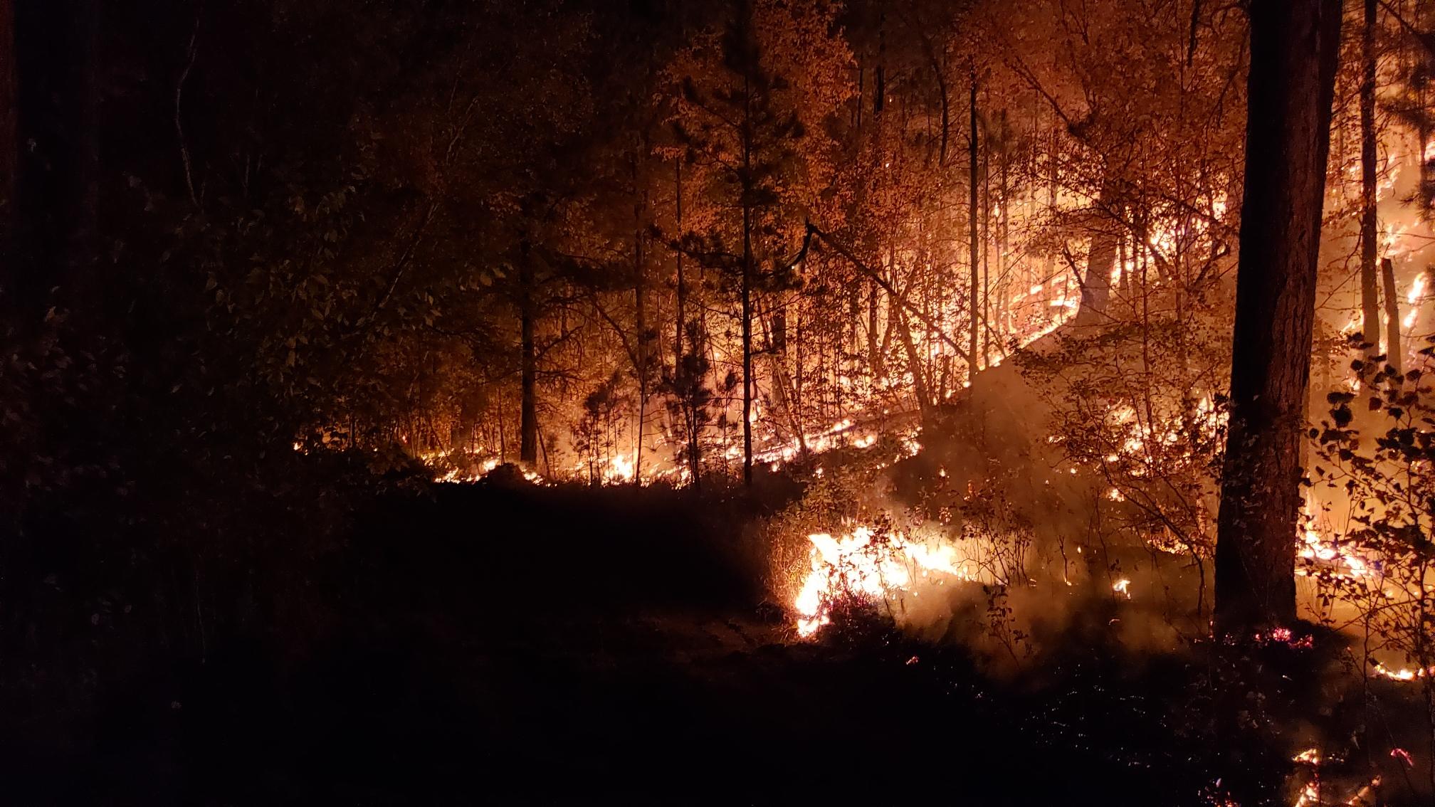
 The fire was reported at 2:42 pm yesterday north of Johnson Siding, approximately 8 miles west of Rapid City.  It was burning south of Bogus Jim Road and west of Norris Peak Road near Forest Service Road 721.   

 Numerous federal, state and local resources responded to the fire. No structures were lost.

 Cause of the fire is under investigation. 


UPDATE: 10:30 pm


UPDATE: 8:00 pm  

Size: 35 acres

Location: off of Norris Peak Road, west of FSR 721

Containment: 75% lined

Cause: under investigation 

Personnel: 130 Federal, State, and local firefighters 


Reported: 2:42 pm, September 28, 2021

Location: North of Johnson Siding and South of Bogus Jim Road, approx. 8 miles west of Rapid City, SD.

Size: Initial Size up is 8-10 acres

Resources: Federal, State and local resources are responding. Engines, handcrews, dozers are on scene and air resources have been ordered. 

Cause: Unknown and under investigation.

Monday, September 27, 2021


Bob Marshall – Wildfire

Reported: 12:16PM 09/27/2021

Location: Bismarck Lake

Size: .01 acres

Resources: Federal, State, and Local

Cause: Human

Contain: 9/27/21 1:15PM

Control 9/27/21 2:20PM

Saturday, September 25, 2021


Skyline - Wildfire

Reported:14:43 09/25/2021

Location: 43 46.164, -103 33.348

Size: .01 acres

Resources:

Contain: 9/25/21 3:20PM

Control 9/25/21 3:23PM

Out: 9/25/21 3:30PM


Hannah - Wildfire

Reported:11:25 09/25/2021

Location: ½ mile from Hannah Campground

Size: .01 acres

Resources:

Contain: 9/25/21 11:29

Control 9/25/21 11:30

Out: 9/25/21 11:35

Friday, September 24, 2021


Wheat CA – Update

Reported:15:52 09/24/2021

Location: 2-3 miles from Rapid City Airport off Longview Rd

Size: 182 acres

Resources: SDS E642

Contain: 5:38PM 09/24/2021


Longview - Update

Reported: 11:37 09/23/2021

Location: Pennington Co, Near Caputa

Size: 110 acres

Resources: SDS E669

Cause: Machinery

Contain: 15:30 09/23/2021


Thursday, September 23, 2021


Longview - Update

Reported: 11:37 09/23/2021

Location: Pennington Co, Near Caputa

Size: 110 acres

Resources: SDS E669

Cause: Machinery

Contain: 15:30 09/23/2021


Longview - Update

Reported: 11:37 09/23/2021

Location: Pennington Co, Near Caputa

Size: Ukn

Resources: SDS E669

Cause: Ukn

Contain: 15:30 09/23/2021


Longview - Wildfire

Reported: 11:37 09/23/2021

Location: Pennington Co, Near Caputa

Size: Ukn

Resources: SDS E669

Cause: Ukn

Tuesday, September 21, 2021


Cut Accross - Update

Reported: 15:47, Sep 21, 2021

Location: Stanley Co 7 mi WNW of Ft Pierre along Hwy

Size: 0.5

Resources:

Cause: Mechanical


Freeland - Update

Reported: 13:26, Sep 21, 2021

Location: Custer Co, Near Richardson Well

Size: 0.25

Resources: BKF BC 31 BKF E431 BKF E633 BKF E634 SDS E654

Cause: Lightning

Contain: 09/21/21 15:00

Control:    09/21/21 16:45


Monday, September 20, 2021


Horsehead CA - Update

Reported: 14:43, Sep 20, 2021

Location: Lat/Long 43 14.322, -103 14.556

Size: 0.1

Resources: UKN

Cause: Unknown

Contain:  09/20/21 15:45

Control:  09/20/21 15:45


Irishman Wildfire - Update

Reported: 10:19 am, Sep 20, 2021

Location: Pennington Co, 4 mi w of Rapid City

Size: 0.1

Resources: Federal /State

Cause: Unknown

Contain:  09/20/21 1100

Control:  09/20/21 1100


Sunday, September 19, 2021


MM 106 CA Wildfire-UPDATE

Reported: 15:29 PM, Sep 19, 2021

Location:

Size: 3.71

Resources: Federal

Cause:

Contain:09/19/2021

Saturday, September 18, 2021

1st Thunder Wildfire-UPDATE

Reported: 15:12 PM, Sep 18, 2021

Location: 2371 Dry Sage Ln

Size: 1.72

Resources: Federal/State

Cause:

Contain: 09/18/21, 1830 PM

Control:09/19/2021,1200


Grand Vista Wildfire-UPDATE

Reported: 13:21 PM, Sep 18, 2021

Location: Ditch Creek Rd S to FR 2913N

Size: 2.2

Resources: Federal/State

Cause:

Contain: 9/19/2021, 1200

Control: 9/19/2021, 1400


Castle Butte Hay Wildfire-UPDATE

Reported: 09:30am, Sep 18, 2021

Location:

Size: 0.25

Resources: State

Cause:

Contain: 16:55, 18 Sep 2021


Friday, September 17, 2021

White Horse Wildfire

Reported: 10:57 AM, Sep 17, 2021

Location: 1mi E Bear Mt

Size:0.10

Resources: Federal/local

Cause: campfire

Contain: 11:45 AM 9/17/2021


Vista Trend CA Wildfire

Reported: 07:09 AM, Sep 17, 2021

Location: Scott Bluff County, 8 miles West of Gering, NE

Size: 3600

Resources:

Cause: Unknown


Thursday, September 16, 2021

Wildfire south of Crawford, Nebraska (UPDATED 9/17/21 at 11:15am)

September 17, 2021

All future press releases regarding the Post Fire will be shared on the Nebraska National Forests and Grasslands Facebook page.  


September 16, 2021

A fast-moving wildfire is prompting evacuations approximately 4 miles south of Crawford, Nebraska. Please evacuate immediately if you are within the area west of Highway 71, south of 4-mile Road, east of Deadman Road & north of West Belmont Road. Dawes County Sheriff's Office is currently notifying residents with door-to-door directions to evacuate.

Federal, State and Local firefighters are on-scene as the fire has grown to 600 acres. A Single-Engine Air Tanker is providing air attack and a Type 3 Incident Management Team has been ordered.


Job Corps 2Wildfire -UPDATED

Reported: 17:48pm, Sep 16, 2021

Location: 8 mi s of Chadron E on HWY 385

Size: 0.2

Resources: Federal/Local

Cause: Lightning

Contained: 19:15,09/16/2021


Bluebird Wildfire- UPDATE

Reported: 17:33 pm, Sep 16, 2021

Location: Custer co, Pleasant Valley area s of 12 mi Ranch ,2.5 mi n of Game      Production Area

Size: 0.1

Resources: Federal/State

Cause: unknown

Contained: 18:15, 09/16/2021

Control: 1930, 09/16/2021


Roubaix Wildfire - UPDATE

Reported: 14:18 pm, Sep 16, 2021

Location: ½ M West of Roubaix Lake Law County Sd

Size: 0.34

Resources: Federal/State/Local

Cause: Lightning

Contain: 1700, 09/16/2021

Control: 1745, 09/16/2021


FAL Wildfire

Reported: 13:09 pm, Sep 16, 2021

Location:

Size: 0.1

Resources: Unknown

Cause: Unknown


Wednesday, September 15, 2021

Bowman Ridge Wildfire-UPDATE

Reported: 12:04 pm, Sep 15, 2021

Location: Custer Co, 2 mi nne of Pringle, near Pink Elephant Mine

Size: 1.5

Resources: Federal

Cause: Lightning

Contain: 1401pm, 9/15/2021


Tuesday, September 14, 2021


Elliot Wildfire

Reported: 16:55 pm, Sep 14, 2021

Location:

Size: 0.1

Resources: State

Cause: Unknown

Contain: 1800 pm, Sep 14, 2021

Control: 1800 pm, Sep 14, 2021

Out: 1800 pm, Sep 14, 2021


Job Corps Wildfire - UPDATE

Reported: 14:53 pm, Sep 14, 2021

Location: ne of Pine Ridge Job Corps

Size: 3.8

Resources: Federal/Local/SEATS

Cause: Unknown


Monday, September 13, 2021

September 13, 2021


Wildfire Update - 10/13/21

 Battle Ax Fire

·                Reported: 11:40 a.m. on 10/11/2021

·                Location: 3 miles northwest of Hill City, SD

·                Size: .1 acre

·                Resources: Federal and local resources responded.

·                Cause: human

·                Contained and controlled at 1:30 p.m. on 10/11/2021

·                Out at 1100 AM on 10/12/2021

Friday, September 10, 2021

September 10, 2021

Restmore Wildfire

Reported: 11:46 am, Sep 10, 2021

Location: Pennington County, 2.5 miles south of Hill City

Size: .1 acre

Resources: Federal and State

Cause: Unknown

Contained and Controlled at 1:21 pm, Sep 10


Monday, September 6, 2021

September 6, 2021

719 Fire

Reported: 1:43 a.m.

Location: Dawes County, 1 mile east of Chadron State Park

Size: 10 acres

Cause: undetermined

Resources: Federal, State and Local

Sunday, September 5, 2021

September 5, 2021

Ditch Creek Fire

Reported: 1:13 p.m.

Location: Pennington Co., off Ditch Creek, 13.5 mi. W. of Hill City, SD

Size: 0.1 acre

Contained: 1:30 p.m.

Controlled: 1:30 p.m.

Out: 1:30 p.m.

Saturday, September 4, 2021

September 4, 2021

Antelope Ridge Fire

Reported: 4:35 p.m.

Size: 0.1 acre

Contained: 7:23 p.m.

Controlled: 7:23 p.m.


Signal Fire

Reported: 3:40 p.m.

Location: Custer County, 7 miles NW of Jewell Cave

Size: 6.3 acres

Resources: Federal, State and Local

Cause: Lightning

Contained: 11:05 a.m., 9/5/21

Controlled: 2:30 p.m., 9/5/21


Layton Fire


Reported: 1:47 p.m.

Location: Custer County, 3 miles SE of Jewell Cave

Size: 0.4 acres

Cause: Lightning

Resources: Federal

Contained: 3:50 p.m.

Controlled: 8:08 p.m.


Railroad Butte Fire

Reported: 11:42 a.m.

Size: 0.1 acre

Resources: State, Federal

Contained: 2:00 p.m.

Controlled: 2:30 p.m.

Out: 3:10 p.m.