- U.S. Forest Service Mystic fire will be burning large piles created by machines today, approximately 2 miles west of Hill City, SD off of Battle Axe Road. Piles are made of woody debris (slash) and are burned in an effort to reduce hazardous fuels. These piles are made from the slash left after mechanical thinning or cutting of trees in the forest.
Friday, December 29, 2017
12-29-17 Pile Burning
Thursday, December 28, 2017
12-28-2017 Pile Burning
- Nebraska National Forests & Grasslands, Pine Ridge Ranger District will be burning piles today south of Chadron, NE near Kings Canyon.
- Hell Canyon fire on the Black Hills National Forest will be burning around 100 piles today 5 miles west of Custer, SD.
Wednesday, December 27, 2017
12-27-17 Pile Burning
- Black Hills National Forest Hell Canyon fire will be burning approximately 126 piles today near Red Bank Spring.
Saturday, December 16, 2017
Legion Lake Fire Update
Saturday, Dec. 16, 9:00 a.m.
CUSTER STATE PARK – Containment lines and moderate fire behavior allowed firefighters to continue mop up and patrol efforts on Friday night around all areas of the fire. Due to more accurate mapping by ground crews, the acreage did increase to 54,023, while containment holds at 80 percent for Saturday. Fire managers will re-evaluate containment this afternoon, but it is expected to increase.
Snow is in the forecast for today, which is expected to accumulate in the higher elevations of the fire area and will add additional support for fire containment.
Friday, some interior timber stands were burned, so smoke was very visible. Those areas were well within the fire perimeter and are not expected to produce as much smoke today, as most of the fine fuels were consumed.
Rocky Mountain Team Blue will officially transfer command at 6:00 p.m. this evening to a type three organization. Additional resources continue to be demobilized.
Custer State Park and all interior roads within the park remain closed.
All areas of Wind Cave National Park with the exception of Highway 385, Highway 87, Beaver Creek Road, associated turnouts and the immediate area around the visitor center are closed to all public entry.
Fire Desk information and updates can be provided by emailing LegionLakeFire@gmail.com or by calling 605-646-3263.
Fire Information Desk: 605-646-3263
LegionLakeFire@gmail.com
Social Media: @CusterStatePark
Facebook.com/CusterStatePark
Thursday, December 14, 2017
Thursday December 14
Legion Lake Fire Update
- Size: 47,312 acres
- Containment: 10%
- Resources: Local, State, and Federal
- Evacuations in Effect
- Legion Lake Fire Information: (605)-646-3263/email: LegionLakeFire@gmail.com
- More information is posted at: http://gpfireinfo.blogspot.com/p/large-incident.html
- Social Media:
- @CusterStatePark
- Facebook.com/CusterStatePark
Wednesday, December 13, 2017
Wednesday December 13
Legion Lake Fire Update
- Size: 35,000 acres
- Containment: 7%
- Resources: Local, State, and Federal
- Evacuations in Effect
- Legion Lake Fire Information: (605)-646-3263/email: LegionLakeFire@gmail.com
- More information is posted at: http://gpfireinfo.blogspot.com/p/large-incident.html
- Social Media:
- @CusterStatePark
- Facebook.com/CusterStatePark
Tuesday, December 12, 2017
Tuesday, December 12
Legion Lake Fire UPDATE
- Size: 4,000 Acres
- Resources: Local, State, and Federal
- Road Closures: Still in effect
- Type 2 Incident Management Team now managing incident
- Containment: 0%
- Priority: Structure Protection
- For information the Legion Lake Fire call (605)-646-3263 Direct
Monday, December 11, 2017
Update Monday December 11, 2017
Legion Lake Fire
- Location: Near Legion Lake Lodge, Custer State Park
- Size: 2,500 Acres
- Resources: State and Federal
- Cause: Human
- Road Closures: Near Devil's Triangle, including portions of Highways 16A and 87
- Type 2 Incident Management Team Ordered
- For information the Legion Lake Fire call (605)-646-3263 Direct
Bug Fire
- Location: 6 Miles North Custer, SD
- Size: 12.5 Acres
- Resources: State and Federal
- Cause: Human
Thursday, December 7, 2017
12-7-17 Pile Burning
- South Dakota Wildland Fire handcrews will be burning approximately 600-700 piles on 40 acres today in the High County Project which is located off of Nemo Road. Crews are igniting today, tending the piles on Friday, and a squad will tend and patrol the piles on Saturday.
Wednesday, December 6, 2017
12-6-17 Pile Burning
- Black Hills National Forest Hell Canyon fire will be burning piles today in the Red Bank Spring area as conditions permit.
- The South Dakota State Black Hat Handcrew is assisting the Bureau of Land Management today with slash pile burning in the Englewood Subdivision, south of Lead. Approximately 100 piles are planned to be burned.
- Black Hills National Forest Mystic fire will be burning piles tomorrow, 12/7/17, near Deerfield lake.
Tuesday, December 5, 2017
12/5 - 12/6/17 - Pile Burning
- Black Hills National Forest Hell Canyon fire is burning piles south of the O’Neil Pass area today.
- Starting tomorrow, 12/6/17, Black Hills National Forest Bearlodge fire will be burning piles near Cook Lake Campground and off of Fawn Creek Road, approximately 13 miles North of Sundance, WY.
Monday, December 4, 2017
12-4-17 Pile Burning
The Northern Hills Ranger District on the Black Hills National Forest is burning hand and machine slash piles starting today and continuing through the week, as conditions permit.
Piles will be burned approximately 2.5 miles south of Hanna. Smoke will be visible from North Rochford Rd., Hanna Rd. and Hwy 85 NE of Cheyenne Crossing.
Piles will also be burned near the Spearfish Forest Service Work Center.
Piles are created from timber sale slash, tree thinning operations and are burned to reduce hazardous fuels.
Firefighters will continually monitor and check the piles for several days after they have been lit.
Monday December 4, 2017
Twin Springs Fire
- Size: 0.5 Acre
- Location: 3 Miles East of Hill City
- Resources: Federal and Local
- Cause: Powerline
Wednesday, November 29, 2017
Silver Mountain Prescribed Fire Project to Continue West of Rapid City, SD

Rapid City, South Dakota, Nov. 29, 2017 – The Mystic Ranger District on the Black Hills National Forest is planning to continue ignition on the Silver Mountain project Thursday, Nov. 30 and Friday, Dec. 1, depending on weather.
One hundred and 8 acres were successfully ignited Oct. 31, 2017. Fire managers plan to burn an additional 389 acres Thursday through Friday.
The project area is located near Rockerville, South Dakota, west of Boulder Hill and east of Beretta Road. Ignition will begin late morning and last throughout the day. A night shift will patrol following ignitions.
Smoke will be visible for several miles and could impact Highway 16, Hill City, Rapid City and other surrounding areas.
For every prescribed burn, specialists write burn plans. Burn plans identify, or prescribe, the best conditions under which trees and other plants will burn to get the best results safely. Burn plans consider temperature, humidity, wind, moisture of the vegetation, and conditions for the dispersal of smoke.
Implementation is also supported by a National Environmental Policy Act (NEPA) document. Specialists such as: hydrologists, archaeologists, wildlife biologists, among others, are involved with this process that requires federal agencies to integrate environmental values into their decision making processes by considering the environmental impacts of their proposed actions and reasonable alternatives to those actions.
With all of the planning that goes into a prescribed fire project, managers will not ignite a project unless the conditions meet the criteria described in the burn plan. “We spend years planning,” said Wayne Yanders, Black Hills National Forest firefighter. “If we are out of prescription, we will cancel the burn and wait for a better day.”
The right fire, at the right place, at the right time can reduce hazardous fuels, protect communities from extreme fires; minimize the spread of pest insects; remove unwanted species that threaten species native to an ecosystem; provide forage for game; improve habitat for species; recycle nutrients back to the soil; and promote the growth of trees, wildflowers and other plants.
As conditions permit, fire officials will continue to assess ignition of other prescribed burn units across the Black Hills National Forest.
For more information on Black Hills National Forest prescribed fire, visit http://www.fs.usda.gov/detail/blackhills/landmanagement/resourcemanagement/?cid=STELPRDB5112694
-USDA-
USDA is an equal opportunity provider, employer and lender.
Wednesday, November 22, 2017
November 22, 2017
Dry Creek CA (1:58 pm)
- Located 7 miles south of Hermosa
- Size: 291.1 acres
- Federal, State and local resources responded
- Human caused
Saturday, November 18, 2017
November 18, 2017
Stagecoach (3:18 pm)
- Located on Stagecoach Springs Road in Custer
- Size:
10 acres17 acres - Human Caused
- State and local resources responded
Thursday, November 16, 2017
November 16, 2017
Slicker (1:30 pm)
- Located 5 miles south of Chadron
- Human caused
- Federal and local resources responded
- Size: 30 acres
Wednesday, November 15, 2017
November 15, 2017
Reservoir Road CA (12:31 pm)
- Located at 104 N Reservoir Road in Rapid Valley
- State resources on scene
- Size: 10 acres
- Human caused
- Located approximately 1.5 miles south/southeast of Cement Ridge
- Abandoned campfire
- .10 acres
- Contained at 12:40 pm and controlled at 1:00 pm
Black Gap (2:42 pm)
- Located in Pennington County, approximately 7-8 miles s of Rapid City, Hwy 79
- Human caused
- 2.2 acres
- Controlled
Video credit: Taft Tubbs
Tuesday, November 7, 2017
11-7-17 Pile Burning
Bearlodge fire on the Black Hills National Forest is burning handpiles today at the top end of Rattlesnake Canyon, about 2 miles South of Cement Ridge Lookout, WY.
Monday, November 6, 2017
11-6-17 Pile Burning
Black Hills National Forest Hell Canyon fire will be burning piles today in the Red Bank Springs area if conditions warrant.
Thursday, November 2, 2017
11-2-17 Pile Burning
Mystic fire on the Black Hills National Forest is planning to burn hand piles today adjacent to Highway 16 & Hardesty Road. Ignitions may continue tomorrow, 11/3, if conditions are favorable. Smoke will be visible along Highway 16 for several days. Patrols are planned through the weekend and signs have been placed along the highway.
Tuesday, October 31, 2017
Prescribed Fire at Stockade Lake
South
Dakota Department of Agriculture’s Wildland Fire Division and the South Dakota
Department of Game, Fish and Parks have started ignitions on a
prescribed burn at Stockade Lake.
Firefighters
are planning on burning approximately five acres. This project is located on
the west side of Stockade Lake near the beach and boat ramp area in Custer
State Park.
The
objectives of the burn are to reduce the hazardous buildup of debris and dead
vegetation, which can fuel wildfires, and remove the dead layer of reeds to
stimulate new growth. Weather conditions will be monitored closely to
ensure prescribed fire conditions align with management objectives for the
burn.
Smoke
may be visible in the surrounding areas and can linger for several days after
ignition has been completed. Fire crews will secure, patrol and monitor fire
lines as appropriate for public and firefighter safety. For more information on
smoke management visit: http://gpfireinfo.blogspot.com/p/smoke-management.html.
Monday, October 30, 2017
Silver Mountain Prescribed Fire Planned West of Rapid City, SD
 |
| Check out Silver Mountain Prescribed Fire Photos at: https://www.facebook.com/pg/blackhillsnf/photos/?tab=album&album_id=1879411548986106 |
Silver Mountain Prescribed Fire Planned West of Rapid City, SD
Rapid City, SD, October 30, 2017 – The Mystic Ranger District on the Black Hills National Forest is planning to ignite 108 acres on the Silver Mountain project Tuesday, October 31, depending on weather. Smoke will be visible for several miles and could impact Highway 16, Hill City, Rapid City and other surrounding areas. Crews have been preparing to implement the project to meet management objectives for several years.
The Silver Mountain project area is located approximately 10 miles west/southwest of Rapid City, SD between Highway 16 and Sheridan Lake Road, along Boulder Hill Road to the west.
The goal of the Silver Mountain Prescribed Fire is to maintain a mosaic of vegetation conditions created by the Battle Creek Fire of 2002. This project will lessen the severity and extent of future wildfires in the project area by breaking up the continuity of dead, downed fuels, ultimately reducing those fuel loads. Fire will also be utilized as a tool to thin pine regeneration and increase canopy base heights. Additionally, this burn will stimulate browse for big game species.
After many years of fire exclusion, an ecosystem, such as the Black Hills, needs periodic fire to remain healthy. Without it, trees are stressed by overcrowding, fire-dependent species disappear, and flammable fuels build up and become hazardous.
Forest visitors, including hunters, are asked to be aware of their surroundings and watch for prescribed burning operations in the months ahead. Areas where burning operations are taking place will be signed to notify visitors. The public is also encouraged to contact a nearby Forest Service office with questions.
As conditions permit, fire officials will continue to assess ignition of other prescribed burn units across the Black Hills National Forest.
For more information on Black Hills National Forest prescribed fire, visit http://www.fs.usda.gov/detail/blackhills/landmanagement/resourcemanagement/?cid=STELPRDB5112694
-USDA-
USDA is an equal opportunity provider, employer, and lender.
10/30/17 - NOTE: Bearlodge Fire is planning to burn hand piles in the Cook Lake campground area today and continuing through the week, depending on weather and snow cover. It is part of a multi-year fuel treatment at the administrative site.
Tuesday, October 24, 2017
October 24, 2017
Oak Meadows Wildfire
Reported: 12:15 pm, Oct 24, 2017
Location: Play House road and Hwy 40 (2 miles northeast of Lakota Lake)
Size: .35 acres
Cause: Unknown
Resources: Federal, State and local
Reported: 12:15 pm, Oct 24, 2017
Location: Play House road and Hwy 40 (2 miles northeast of Lakota Lake)
Size: .35 acres
Cause: Unknown
Resources: Federal, State and local
Monday, October 2, 2017
Hand Piles burning Oct 2,2017
Black Hills National Forest Central Zone Fire is planning to
ignite hand piles in the Tigerville area, Hound Dog unit 1, on Monday, October
2, weather permitting.
This project
is located approximately 5 miles northwest of Hill City, SD.
Smoke
may be visible from Tigerville, Hill City, along Deerfield Road and the
surrounding area. Firefighters will remain on scene monitoring the piles for as
long as needed.
Weather
conditions will be monitored closely to ensure conditions align with management
objectives.
Tuesday, September 19, 2017
September 19, 2017
Mile Marker 121 Fire
- Reported: 10:19 AM, September 19, 2017
- Location: Pennington Co, South Dakota - mile marker 121 on Hwy I-90 near Wall
- Size: 0.10 acres
- Cause: human
- Federal and local resources responded
- 100% controlled (10:52 AM)
Thursday, September 14, 2017
September 14, 2017
Red Fern Wildfire
UPDATED: September 18th, 2017
- Reported: 3:26 PM, September 14, 2017
- Location: Dawes Co, Neb, approx 8 mi east of Chadron
- Size: 60 acres
- Cause:
unknownlightning - Federal resources are responding, along with 1 SEAT airplane
- 100% contained
Beaver Wildfire
Beaver Fire Update: Sept 18, 2017
All roads are open and evacuations lifted.
Containment is
Beaver Fire Update: Sept 17, 2017
Crews continue with mop up. Rain and cooler temperatures the past few days have greatly aided the firefighting efforts. Containment is now at 80-90%.
Great Plains Fire Information
Fire
Information
(605)923-8868
September 14, 2017
2:00 pm
Beaver Wildfire
Current Situation: The Beaver wildfire, located in Custer County, 11 miles southeast
of Custer was reported on Sept 13, at approximately 2:00 pm. Federal, State and
Local resources responded and are still on scene. Air resources were also being
used on the fire. The fire is estimated at 400 acres.
No structures have been lost, but 10
structures are threatened, with an additional 20 structures within a mile of
the fire. An indirect dozer line was constructed around the fire last night.
Crews are now working to burn out unburned islands between the fire and the
dozer line.
Weather: Cooler
temperatures and precipitation is forecasted for the next several days. This
weather pattern will help crews as they continue to suppress the fire.
Evacuations: Evacuations
and road closures are in place. Custer County Emergency Management is handling
all evacuations and road closures.
Safety: Road closures on County Road 391 to Hwy.
385 to Hwy. 87. Smoke will continue to be visible in the area for the next
several days. The public is asked to avoid traveling on roads in the vicinity
of the fire for their own safety and the safety of firefighters.
Fire Statistics:
Start Date: September
13, 2017
Location: Custer
County, 4 miles east of Pringle or 11 miles southeast of Custer
Size: Estimated
at 400 acres
Resources: Federal,
State and Local
Cause: Under
investigation
###
Wednesday, September 13, 2017
September 13, 2017
UPDATED 8:40 AM, September 15, 2017
Dry Creek Wildfire
Dry Creek Wildfire
- Reported: 2:24 PM
- Location: Wildlife Loop in Custer State Park
- Size: 0.44 acres
- Cause: lightning
- Federal, State, and local resources are responding
- Contained and controlled at 9:50 AM, Sept. 14, 2017
Wildcat Wildcat
- Reported: 1:38 PM
- Location: South of Hanna Campground, south west of Lead, SD
- Size: 0.2
- Cause: lightning
- Federal and State resources are responding
- Controlled at 5:45 PM
Beaver Wildfire
- Reported: 1:58 PM
- Location: west of Rankin Wildfire
- Size: 400 acres
- Cause: lightning
- Federal, State, and local resources are responding
- Road closures on County Road 391 to Hwy. 385 to Hwy. 87
- 60% containment at 10:00 AM, September 15, 2017
Rankin Wildfire
Rankin Fire Update
September 16, 2017 – 8:30 am
Rocky Mountain Incident Management Team Black
Shane Greer, Incident Commander
Information Center: (605) 574-1725
Email: RankinFireInfo@gmail.com
Hours of Operation: 8:00 a.m. – 5:00 p.m.
Note: This will be the final update for the Rankin Fire from Rocky Mountain Team Black. At 7:00 a.m. on Saturday, September 16, command of the fire has transitioned back to Wind Cave National Park. Information will continue to be posted on InciWeb (https://inciweb.nwcg.gov/
Current Situation: The Rankin Fire is now 100 percent contained. There has been no growth of the fire for two days, and the size remains 2,133 acres. The fire area received 0.3” of rain on Friday. The completion of burnout operations coupled with the expected weather change have reduced the fire’s threat potential.
Weather: A much cooler air mass will push over the fire area Friday night and Saturday with scattered showers tapering off.
Closures: All trails north of and including Wind Cave Canyon Trail remain closed.
Fire Statistics:
Start Date: 09/11/2017
Location: 12 miles Southeast of Custer, SD
Cause: Lightning
Size: 2,133 acres
Containment:100%
For More Information:
Facebook: https://www.facebook.com/
Rankin Fire Update
September 15, 2017 – 10:00 am
Rocky Mountain Incident Management Team Black
Shane Greer, Incident Commander
Information Center: (605) 574-1725
Email: RankinFireInfo@gmail.com
Hours of Operation: 8:00 a.m. – 9:00 p.m.
Current Situation: Fire crews continue to make good progress on containment of the Rankin Fire and the fire is now 90% contained. There was no new growth of the fire yesterday however the acreage did increase to 2,133 acres due to better mapping. On Friday, crews will continue to improve containment lines and mop up the few remaining hot spots. Fire behavior is expected to be minimal due to the cooler temperatures and rain.
As fire containment objectives are met, firefighting resources are being released and made available for other fires.
Weather: Temperatures will be cooler with a highs around 62-64 degrees. Light rain is expected to continue until noon with showers becoming more scattered in the afternoon. Winds will be north to northeast at 10 to 15 mph with gusts up to 22 mph.
Safety: Travelers along US Highway 385 and State Route 87 through the park are encouraged to use caution as fire traffic will continue to be heavy along this corridor at times.
Closures: All trails north of and including Wind Cave Canyon Trail are closed for firefighter and visitor safety. NPS 5 is now open.
Fire Statistics:
Start Date: 09/11/2017
Location: 12 miles Southeast of Custer, SD
Cause: Lightning
Size: 2,133 acres
Containment: 90%
Personnel: 202
For More Information:
Facebook: https://www.facebook.com/
Info Line: (605) 574-1725
Email: rankinfireinfo@gmail.com
Rankin Fire Update 09/14/2017
September 14, 2017 -- 4:00 pm
All fire information updates for the Rankin Fire will now be posted only on InciWeb https://inciweb.nwcg.gov/incident/5613/# and Wind Cave National Park's FaceBook site https://www.facebook.com/WindCaveNPS
Rankin Fire Update 09/14/2017
September 14, 2017 – 12:00 pm
Rocky Mountain Incident Management Team Black
Shane Greer, Incident Commander
Information Center: (605) 574-1725
Email: RankinFireInfo@gmail.co
Hours of Operation: 8:00 a.m. – 9:00 p.m.
Current Situation: At 7:00 a.m. on Thursday, September 14, Rocky Mountain Incident Management Team Black assumed command of the Rankin Fire from a local Type 3 management team. The fire was first reported on Monday afternoon and was caused by a lightning strike in the northern part of Wind Cave National Park. Firefighters from multiple agencies have been working to contain the fire since Tuesday. On Wednesday night, crews were able to construct fire line and conduct a firing operation to get containment on the south portion of the fire.
On Thursday, crews will be patrolling the established containment lines and mopping up hot spots.
Weather: On Thursday, the temperature is again expected to be around 80 degrees with relative humidity around 20 to 25 percent. Winds will be north to northeast 5 to 8 for most of the day. Cloud cover will increase through the day and scattered thunderstorms may develop in the afternoon. Wetting rains are expected over the fire late Thursday into Friday.
Safety: Travelers along US Highway 385 and State Route 87 through the park are encouraged to use caution as fire traffic will continue to be heavy along this corridor at times. At times smoke will impact roads in the park and visitors are urged to slow down and use caution.
Closures: NPS 5, from the junction of State Route 87 to the junction of NPS 6, and all trails north of and including Wind Cave Canyon Trail are closed for firefighter and visitor safety.
Fire Statistics:
Start Date: 09/11/2017
Location: 12 miles Southeast of Custer, SD
Cause: Lightning
Size: 1192 acres
Containment: 90%
Containment: 90%
For More Information:
Facebook: https://www.facebook.com/WindC
Wind Cave National Park News Release
Release
Date:
 September 13, 2017
Crews Continue Efforts to Suppress Fire
Burning in Wind Cave National Park
WIND
CAVE NATIONAL PARK, SD – Firefighters continued their efforts to contain a
1,000 acre fire burning in the interior of Wind Cave National Park. The fire
started in the northern region of the park and has been burning to the south,
into the park, since it was first reported Monday afternoon. The fire is burning
in steep, rocky terrain east of Highway 87 and south of road NPS 5.
Crews Wednesday worked on line construction
to meet containment objectives on the east and west boundaries of the
fire. At this time, there is 0%
contained. Ground crews were aided with water drops from two heavy air tankers
and a South Dakota Air National Guard Black Hawk helicopter.
Due to the increased complexity of the fire,
a Type II incident management team is scheduled to assume management of the
fire Thursday morning. This team is bringing logistical support, overhead
resources, and additional hand crews.
Federal, state, and local crews assigned to
the fire are from the National Park Service, Black Hills National Forest, South
Dakota Division of Wildland Fire, Custer State Park, Nebraska National Forest,
South Dakota Department of Corrections, Wyoming Department of Corrections, Boxelder
Job Corps Civilian Conservation Center, South Dakota National Guard, the
Custer Ambulance Service, and various volunteer fire departments.
Currently
the only closures are the northern segment of NPS 5 and all backcountry hiking
trails north of Wind Cave Canyon. The park visitor center remains open with
cave tours leaving from 9 a.m. to 4:30 p.m. throughout the day.
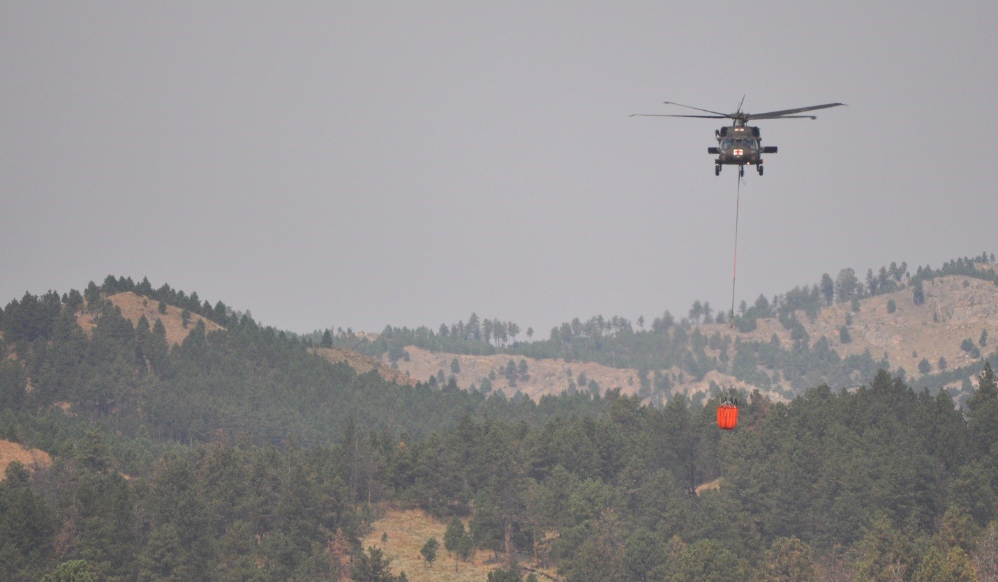 |
| Photo Caption: Crews working the Rankin Fire were aided by water drops from a South Dakota National Guard Black Hawk helicopter. (NPS Photo) |
Wind Cave National Park News Release
Release
Date: September 12, 2017
Lightning Caused Fire Burning in Wind Cave
National Park
WIND
CAVE NATIONAL PARK, SD – Firefighters from multiple agencies are working to
contain a lightning caused fire in the northern part of Wind Cave National
Park. The fire, first reported Monday afternoon,
is burning east of Highway 87 and south of road NPS 5.
The fire is burning toward the south, in
steep, rocky terrain fueled by grass and timber. A Type III incident management
team is overseeing the work of approximately 85 firefighters and support staff.
Utilizing existing roads, trails, and a mow
line to aid line construction and to provide for firefighter safety, crews
Tuesday successfully conducted a burn-out operation. This operation increased
the size of the burn from 300 acres to around 500 acres. At this time, there is
no estimate of the amount contained or controlled.
“September and October are historically when we
have the biggest fires in the park,” said Park Superintendent Vidal Dávila. “We
encourage everyone to be extra cautious with their outdoor activities due to
the hot and dry conditions we are experiencing.”
Federal, state, and local crews assigned to
the fire are from the National Park Service, Black Hills National Forest, South
Dakota Division of Wildland Fire, Custer State Park, Argyle Fire Department,
Rapid City Fire Department, Nebraska National Forest, South Dakota Department
of Corrections, Wyoming Department of Corrections, Boxelder Job Corps Civilian
Conservation Center, and the Custer Ambulance Service.
Currently the only closures are the northern
segment of NPS 5 and all backcountry hiking trails north of Wind Cave Canyon.
The park visitor center remains open with cave tours leaving from 9 a.m. to
4:30 p.m. throughout the day.


 |
| Photo Caption: Crews are currently fighting the Rankin Fire in Wind Cave National Park. (NPS Photo) |


Tuesday, September 12, 2017
September 12, 2017
UPDATED 6:00 PM, September 13, 2017
Coffee Wildfire
Pasture 16 Wildfire
Cold Draw Wildfire
#6 Wildfire
Rock Wildfire
East 40 Wildfire
Snyder Ranch Wildfire
Sanders Wildfire
Rankin Wildfire
For latest information, please call Tom Farrell, Public Information Officer, at 605-745-1130
Coffee Wildfire
- Reported: 5:35 PM
- Location: Sioux County, Nebraska, near Montrose
- Size: 750
- Cause: lightning
- Local resources, and 1 SEAT aircraft responded
- Contained and controlled
Pasture 16 Wildfire
- Reported: 5:00 PM
- Location: Sioux County, Nebraska, 22 mi NW of Crawford.
- Size: 51
- Cause: lightning
- Federal and local resources responded
- Contained
Cold Draw Wildfire
- Reported: 4:45 PM
- Location: 25 miles southwest of Wall, SD
- Size: 14.79
- Cause: lightning
- Federal and local resources responded
- Contained
#6 Wildfire
- Reported: 3:58 PM
- Location: Fall River County, 1 mile south of mile marker 70 on Hwy. 18, Slim Buttes Rd.
- Size: in mop up stages, more information to follow
- Cause: lightning
- Local resources responded
Rock Wildfire
- Reported: 3:29 PM
- Location: Dawes co, NE 6-7 mi s of Crawford, NE
- Size: 2.6 acres
- Cause: lightning
- Federal, State, and local resources responded
- Contained
East 40 Wildfire
- Reported: 3:16 PM
- Location: near Badlands National Park
- Size: 152 acres
- Cause: lightning
- Federal and State resources are responding
- Contained
Snyder Ranch Wildfire
- Reported: 3:00 PM
- Location: near weigh station on I-90, Meade County
- Size: .25
- Cause: lightning
- Federal, State resources are responded
- Contained
Sanders Wildfire
- Reported: 8:30 am
- Location: Bald Hills area along Hwy. 385/Victoria Lake Road
- Size: 3.5 acres
- Cause: human caused
- Federal, State, and local resources responded
- Contained
Rankin Wildfire
For latest information, please call Tom Farrell, Public Information Officer, at 605-745-1130
- Reported: 1:57 pm - September 11
- Location: 1 SSW of Highland Creek Trailhead in Wind Cave National Park
- Size: Estimated 1,000 acres
- Cause: Lightning
- Federal, State, and local resources are on scene, including air attack
- 0% containment at this time
- Crews worked throughout the night burning out the southern portion of the fire (up to NPS 5 Road and the intersection with Hwy. 87). Incident commander is concerned about the current south winds and crews are working now to secure the northern portions or the fire.
Blackhawk Wildfire
- Reported: 5:52 pm - September 11
- Location: Crook County, WY - Near Cook Lake
- Size: 8.3 acres
- Cause: Human Equipment
- Federal, State, and local resources are on scene and in mop-up
- 100% containment reached at 4:30 PM, September 13, 2017
Monday, September 11, 2017
September 11, 2017
Updated at 9:00 PM
Rankin
Italy
Rankin
- Reported: 1:57 pm - September 11
- Location: 1 SSW of Highland Creek Trailhead in Wind Cave National Park
- Size: Estimated 20-30 acres
- Cause: Lightning
- Resources are on scene, additional resources ordered.
Blackhawk
- Reported: 5:52 pm - September 11
- Location: Crook County, WY - Near Cook Lake
- Size: Estimated 5 acres
- Cause: Human Equipment
- Resources are on scene
- Reported: 2:45 pm - September 11
- Location: W of Custer, SD
- Size .25 acre
- Cause: Unknown
- Contained
- Reported: 5:30 am - September 11
- Location: 7 miles SE of Oelrichs, SD
- Size: 65 acres
- Cause: Lightning
- Contained
Sunday, September 10, 2017
Sep 10, 2017
Camp 3 Wildfire:
Reported: 7:36 pm (Sep 9)
Location: Halsey Forest (about 70 miles south of Valentine, NE)
Size: 1.78 acres
Resources: Federal
Cause: Unk
Contained
Angostura Road Wildfire - update:
Reported: 1:22pm (Sep 9)
Locatation: Maverick Junction
Size: .72 acres
Resources: Federal & State
Cause: unk
Contained
71 Wildfire - update:
Reported: 2:49 pm (Sep 8)
Location: 5 miles south of Crawford, NE
Size: 2 acres
Resources: State & local
Cause: unk
Contained
Breakneck Wildfire - update:
Reported: 4:44 pm (Sep 8)
Location: 8 miles north of Newcastle, WY (Weston Co)
Size: 7.2 acres
Resources: Federal, State & local
Cause: unk
Contained
Contained
71 Wildfire - update:
Reported: 2:49 pm (Sep 8)
Location: 5 miles south of Crawford, NE
Size: 2 acres
Resources: State & local
Cause: unk
Contained
Breakneck Wildfire - update:
Reported: 4:44 pm (Sep 8)
Location: 8 miles north of Newcastle, WY (Weston Co)
Size: 7.2 acres
Resources: Federal, State & local
Cause: unk
Contained
Saturday, September 9, 2017
Sep 9 Wildfires
Angostura Road wildfire
Reported: 1:22pm
Locatation: Maverick Junction
Size: .5 Are
Resources: Federal & State
Cause: unk
Sep 8 Wildfires
71 Wildfire
Reported: 2:49 pm
Location: 5 miles south of Crawford, NE
Size: 2 acres
Resources: State & local
Breakneck Wildfire
Reported: 4:44 pm
Location: 8 miles north of Newcastle, WY (Weston Co)
Size: 7.2 acres
Resources: Federal, State & local
Reported: 2:49 pm
Location: 5 miles south of Crawford, NE
Size: 2 acres
Resources: State & local
Breakneck Wildfire
Reported: 4:44 pm
Location: 8 miles north of Newcastle, WY (Weston Co)
Size: 7.2 acres
Resources: Federal, State & local
Monday, September 4, 2017
September 4, 2017
Sheps Canyon (11:17 am)
- Located in Sheps Canyon in Fall River County
- Size:
3 acres13.3 acres - State and Federal resources on scene
- Cause: abandoned campfire
30% contained
September 5th update
- 100% contained as of 11:52am and 100% controlled as of 1:15pm
Sunday, September 3, 2017
September 3, 2017 - Updated
Black Fox Fire
- Location: US Forest Service Black Fox Campground, 7 miles West of Rochford, SD
- Size: .1 acres
- Cause: illegal campfire
- Reported @ 7:32 p.m.
- Federal & local resources responded.
- Contained, Controlled & Out @ 8:45 p.m.
- Check local fire restrictions at http://www.blackhillsfirerestrictions.com/.
- Location: Meade County, 30 miles North of Wall, SD
- Size: 51 acres
- Cause: equipment
- Reported @ 1:34 p.m.
- Federal & local resources responded.
- Contained @ 3:30 p.m.
Thursday, August 31, 2017
August 31, 2017 - Updated
Pasture 12 Fire
959 Fire
Woodpecker Fire-Updated @ 3.13 p.m.
- Location: Oglala National Grasslands in Nebraska, south of Ardmore, SD
- Size: 2.1 acres
- Cause: lightning
- Reported @ 7:51 p.m.
- Federal & local resources responded.
- Contained & Controlled @ 9:00 p.m.
959 Fire
- Location: Oglala National Grasslands in Nebraska, south of Ardmore, SD
- Size: 2.5 acres
- Cause: lightning
- Reported @ 5:40 p.m.
- Federal & local resources responded.
- Contained & Controlled @ 9:00 p.m.
Woodpecker Fire-Updated @ 3.13 p.m.
- Location: 1.5 miles SW of Lakota Lake near Keystone, SD
- Size: .1 acre
- Cause: lightning
- Reported @ 8:35 a.m.
- Federal, State, & local resources responding.
- Contained @ 2:00 p.m.
Elk Run Fire - Updates
Elk Run Fire - Updated -4:00 p.m. MDT 9/2/2017
- Fire Name: Elk Run Fire
- Cause: Lightning
- Date of Origin: The Fire was reported @ 3:16 p.m. 8/30/2017
- Location: Private and US Forest Service land in Custer County-2 miles southwest of Argyle, SD
- Total personnel: Tomorrow’s resources will be approximately 15 which include 1 engine, 1 hand crew, and various overhead positions. Federal, State & local resources on scene.
- Size: approximately 225 acres. A change in acreage may occur due to more accurate GPS mapping.
- Containment: 100%
- No further structures are threatened as the threat has been mitigated. No road closures are in effect.
- More information on this incident can be found on the Ongoing Incident tab on the blog.
Wednesday, August 30, 2017
August 30, 2017 - Updated
Elk Run Fire - Updated 10:07 p.m.
- Location: Private land in Custer County, South of Argyle, SD & West of Hwy 89
- Size: approx. 400 acres
- Multiple structures threatened, 1 structure involved
- Reported @ 3:16 p.m.
- Federal, State & local resources responding
- Structure protection & air resources were ordered.
- 3 Single Engine Air Tankers (SEATs), 1 heavy air tanker, and 1 SD National Guard Blackhawk are on-scene.
- For evacuation information, please contact Custer County Sheriff's Office at: (605) 673-8146.
- Location: Private land along Beaver Creek Road, 6 miles NE of Newcastle, WY
- Size: .1 acre
- Cause: lightning
- Reported @ 9:30 a.m.
- Federal & local resources responded
- Contained @ 10:30 a.m.
Tuesday, August 29, 2017
August 29, 2017 - Updated
Cowboy Gulch Fire
Sand Creek Fire
- Location: 1.5 miles South of Hill City, SD
- Size: .1 acre
- Cause: human
- Reported @ 1:50 p.m.
- Federal resources responded
- Contained, controlled, & out at 2:45 p.m.
Sand Creek Fire
- Location: Black Haw Gulch
- Size: 2.75 acres
- Cause: Lightning
- Federal resources responded
- Contained @ 12:00 p.m., 8/28/2017
Sunday, August 27, 2017
August 27, 2017
Sand Creek 3:51 PM - August 26
Datum Creek (Thursday #2) 10:59 PM- August 24
- Location: Black Haw Gulch
- Size: 2.7 acres
- Cause: Lightning
- Resources on scene
Datum Creek (Thursday #2) 10:59 PM- August 24
- Location: N. of Crow Peak
- Size: .44 acre
- Cause: Unknown
- Controlled
Friday, August 25, 2017
August 25, 2017
Swather 3:02 PM - August 24
Thursday #2 10:59 PM- August 24
- Location: 2 miles SW of Cement Ridge
- Size: .20 acre
- Cause: Lightning
- Controlled
Thursday #2 10:59 PM- August 24
- Location: N. of Crow Peak
- Size: 10 acres (approximately)
- Cause: Unknown
- Resources on scene
- Location: Bearlodge Ranch, Crook County, WY
- Size: .10 acre
- Cause: Lightning
- Resources on scene
- Contained
- Location: Miller Creek Area
- Size: .10 acre
- Cause: Lightning
- Controlled
Thursday, August 24, 2017
August 24, 2017
Swather 3:02 - August 24
- Location: 2 miles SW of Cement Ridge
- Size: .20 acre
- Cause: Lightning
- Resources on scene
Tuesday, August 22, 2017
August 22, 2017
Grove 1:26- August 20
- Location: 3 miles North of Haywood
- Size: 10 acres
- Cause: Lightning
- Controlled
- Location: 51N63W15
- Size: 1.59 acres
- Cause: Equipment
- Controlled
- Location: 10 miles West of Bear Mt. Lookout
- Size: 9 acres
- Cause: Lightning
- Controlled
Putnam Dam 10:19- August 18
- Location: 20 miles south west of Custer
- Size: 3-4 acres
- Cause: Lightning
- Controlled
War Drainage 6:19 - August 17
- Location: 11 miles south of Ft Pierre
- Size: 4.6 acres
- Cause: Unknown
- Controlled
Friday, August 18, 2017
August 18, 2017
Putnam Dam Wildfire
Reported: 10:19 am - Aug 18
Location: 20 miles south west of Custer
Size: 3-4 acres
Resources: State, Federal. Air attack, dozers, handcrews, engines ..
Cause: Unknown
War Drainage Wildfire
Reported: 6:19 pm - Aug 17
Location: 11 miles south of Ft Pierre
Size: 4.6 acres
Resources: Local / State / Federal
Cause: Unknown
Contained
UPDATES from Yesterday
Bouquet South Wildfire
Reported: 3:48 pm
Location: 11 miles east of Scenic, SD
Size: 5.9 acres
Resources: local / federal
Cause: lightning
Contained
Pass Creek Wildfire
Reported: 4:36 pm
Location: 10 miles SE of Elk Mountain
Size:5-10 50 acres
Resources: state and federal
Cause: unknown
Contained
Reported: 10:19 am - Aug 18
Location: 20 miles south west of Custer
Size: 3-4 acres
Resources: State, Federal. Air attack, dozers, handcrews, engines ..
Cause: Unknown
War Drainage Wildfire
Reported: 6:19 pm - Aug 17
Location: 11 miles south of Ft Pierre
Size: 4.6 acres
Resources: Local / State / Federal
Cause: Unknown
Contained
UPDATES from Yesterday
Bouquet South Wildfire
Reported: 3:48 pm
Location: 11 miles east of Scenic, SD
Size: 5.9 acres
Resources: local / federal
Cause: lightning
Contained
Pass Creek Wildfire
Reported: 4:36 pm
Location: 10 miles SE of Elk Mountain
Size:
Resources: state and federal
Cause: unknown
Contained
Subscribe to:
Posts (Atom)