Friday, December 2, 2022

December 2, 2022

 Soloman Fire

Reported: 12:49 AM, Dec. 2, 2022

Location: 1 mile west of Rochford in Pennington County

Size: 4.4 acres

Resources Responded: Federal, state, and local


Juniper Fire

Reported: 3:15 PM, Dec. 2, 2022

Location: 1 mile NW of Keystone, SD

Size: 0.1 acre

Resources responded: Federal, state, and local

Cause: Human Caused

Thursday, December 1, 2022

December 1, 2022

 Bogus Jim Creek Fire

Reported: 6:38 AM, Dec. 1, 2022

Location: 8 miles NW of Rapid City in Pennington County

Size: .21 acres

Resources Responded: Federal, state, and local

Cause: Under investigation

Contained: 12/01/22 at 8:00 AM


 Echo Valley Fire

Reported: 11:12 PM, Dec. 1, 2022

Location: 2 miles West of Keystone, SD in Pennington County

Size: 1.27 acres

Resources Responded: State and local

Cause: Human Caused


Wednesday, November 30, 2022

November 30, 2022

Pleasant Fire

Reported: 11:42 AM Nov. 30, 2022

Location: 7 miles east of Dewey, SD in Fall River County

Size: 22 acres

Resources Responded: Federal, state, and local

Cause: Under investigation

Contained: 9:13 AM, Dec. 1,2 2022

Sunday, November 27, 2022

November 27, 2022

 Telegraph Fire

Reported:3:03 PM 

Location: 2 miles west of Rockford, Pennington County

Size: .8 acre

Resources: State, federal, and local

Cause: Under investigation 


Tuesday, November 15, 2022

Palmer Gulch Wildfire - Final Update

Hill City, SD, Nov. 15, 2022 — The Palmer Gulch Fire that started on October 29, is now controlled. Fire crews have been mopping up the area for the past two weeks to ensure all hot spots have been extinguished. The fire burned 88 acres.

“Personnel will be working in the area for the next week or so to rehab dozer lines that were put in to stop the forward progress of the fire,” said Todd Hoover, Fire Management Officer for the Hell Canyon Ranger District, Black Hills National Forest. “There is more cleanup work to do and that will be done in the spring.” 

 The road closure on Palmer Creek Road is no longer in effect. Trails are now open, but the public is asked to avoid use of Palmer Creek Trail #2 until the foot bridge that was burned in the fire has been replaced. Additional safety rehab work on the trails will be completed in the spring.

Monday, October 31, 2022

October 31, 2022

 Treat Fire

Reported: 12:52 PM, Oct. 31, 2022

Location: South of Chadron, NE and East of Highway 385

Size: 1 acre

Resources: Federal and local

Cause: Under investigation

Controlled: Oct. 31, 2:30


Trick Fire

Reported: 2:15 PM, Oct. 31, 2022

Location: South of Chadron

Size: .1 acre

Resources: Federal and local

Cause: Under investigation

Controlled: 4:30, Oct. 31, 2022

Saturday, October 29, 2022

Palmer Gulch Fire

Nov. 15, 2022 - Palmer Gulch Fire Final Update: http://gpfireinfo.blogspot.com/2022/11/palmer-gulch-wildfire-final-update.html

Update as of 9:00 AM, November 3, 2022


Containment has increased to 75% and acreage remains at 88 acres.  

Today firefighters will continue mop up efforts by extinguishing hot spots and reinforcing the fireline. Tomorrow at 8:00 AM, a Type 4 organization will transition command as complexity is decreasing on this fire.  Resources will remain on scene working and monitoring the fire until it is deemed contained.  The public should expect to see smoke within the perimeter of the fire as the heavy dead and down fuels continue to burn.  

For public safety, many trails in the Black Elk Wilderness Area are also closed. Trail #2, #3, #4, #8, #9N, and #9S will be closed until further notice. The public is asked to avoid traveling on roads and trails in the vicinity of the fire for their own safety and the safety of firefighters.


Update as of 7:00 PM, November 2, 2022


Active burning within the interior of the fire line continued today within the dead and down fuels on the Palmer Gulch Fire. Firefighters continued to maintain the fire line, even with the high wind gusts.  

There were gains in containment today as the fire is now at 60%, and due to more accurate mapping size is determined to be 88 acres.  


Update as of 9:30 AM, November 2, 2022


Overnight, heavy dead and down fuels burned within the fire perimeter but the fire remained within containment lines.  The containment has been increased to 50% while the size remains at 87 acres. An estimated 112 personnel are assigned to the fire.  

Today firefighters will continue to reinforce fire line while remaining vigilant about overhead hazards such as snag trees.  Mop up operations continue as firefighters eliminate hot spots near the fire's edge.  

Initial attack support remains in place should a new fire ignite. Aircraft including helicopters, air attack, and Single Engine Air Tankers (SEATs) remain as available resources to firefighters.

From the National Weather Service Spot Forecast:  Low humidity and gusty winds will continue resulting in Red Flag Conditions.  Southwest will increase to 20 to 30 mph by late morning or by noon, with gusts possibly as high as 45 mph. Some decrease in the winds is expected by mid afternoon, decreasing to 15 to 20 mph with gusts up to 35 mph. Winds will drop to 5-10 mph early this evening, then a strong cold front will push through around midnight, bringing gusty north winds. Gusts to 25 mph will be possible. Light snow is expected to develop after midnight tonight, along with temperatures dropping into the upper 20s by daybreak on Thursday. Light snow is also expected after midnight and will continue through the day on Thursday, but snow accumulations are expected to remain under one inch.


Update as of 5:30 PM, November 1, 2022


Today, firefighters were successful in their efforts to hold containment lines during the expected wind event. In addition, they continued to eliminate hazard trees (snags), strengthen line, and  mop up hot spots near containment lines.  Engines will staff the fire overnight.    

Tomorrow's planned action is to hold and reinforce fire line and mop up hot spots within the edge of the fire.  The public should expect to see smoke in the area; heavy dead and down fuels are burning in steep and rugged country.

Containment remains at 40% and 87 acres. 


Update as of 10:00 AM, November 1, 2022


Today, efforts will continue to suppress the Palmer Gulch fire, which has burning since Saturday within the Norbeck Wildlife Preserve, near the Black Elk Wilderness Area.

A Red Flag Warning is in effect from noon today to 9:00 p.m. on Wednesday. Low relative humidity and gusty southwest winds of 10 to 15 mph are expected this afternoon. Firefighters have been working diligently to strengthen containment lines in anticipation of this event. Hazard trees continue to be a safety concern for firefighters along with steep, rugged terrain.

Planned actions are also in place to support initial attack should a new fire ignite. Aircraft including helicopters, air attack, and Single Engine Air Tankers (SEATs) remain as available resources to firefighters.

An estimated 120 personnel are assigned to the fire as the containment stands at 40% and 87 acres.
Palmer Creek Road continues to be closed until further notice. For public safety, many trails in the Black Elk Wilderness Area are also closed. Trail #2, #3, #4, #8, #9N, and #9S will be closed until further notice. Smoke will continue to be thick in the area for the next several days. The public is asked to avoid traveling on roads and trails in the vicinity of the fire for their own safety and the safety of firefighters.


Update as of 5:00 PM, October 31, 2022 


Today, efforts continued to suppress the Palmer Gulch fire, which is burning within the Norbeck Wildlife Preserve, near the Black Elk Wilderness Area. Pleasant weather and moderate fire behavior allowed firefighters to continue to strengthen the lines around the fire. Nearly 100 personnel are assigned to the fire as the containment stands at 40%. Due to more accurate mapping, acreage has been updated to 87 acres.

“Forward progress of the fire has been stopped and crews are working to secure the fire perimeter in preparation for incoming weather” said Todd Hoover, Hell Canyon Ranger District’s Fire Management Officer. A Red Flag Warning is in effect due to dry, windy conditions with the weather forecast at the fire calling for highs in the 60s tomorrow and winds gusting from 20 to 30 mph Tuesday afternoon.

A road closure on Palmer Creek Road is in place until further notice. For public safety, many trails in the Black Elk Wilderness Area are also closed. Trail numbers #2, #3, #4, #8, #9N, and #9S trail will be closed until further notice. Smoke will continue to be thick in the area for the next several days. The public is asked to avoid traveling on roads and trails in the vicinity of the fire for their own safety and the safety of firefighters. 


Update as of 9:30 AM, October 31, 2022

Overnight firefighters held containment lines. The fire is now estimated at 92 acres and remains 40% contained.  The fire is burning in heavy dead and down fuels in steep terrain.  Heavy smoke and snags continue to be a concern for firefighters.  

A Fire Weather Watch has been issued by the National Weather Service for portions of southwestern and south central South Dakota from Tuesday afternoon through Wednesday evening. Warm temperatures, low relative humidity values, and strong southwest to west winds may produce critical fire weather conditions Tuesday afternoon through Wednesday.  


Update as of 7:45 PM, October 30, 2022

Crews are working to suppress the Palmer Gulch wildfire burning approximately 3 miles southeast of Hill City, SD. The fire is estimated at 91 acres in size and is 40% percent contained.  A Type-III Incident Management Team led by Jason Rodriguez, Incident Commander, took over management of the fire at 8 am today.
 
Resources currently assigned to the fire include: one National Guard Blackhawk helicopter, four single engine air tankers (SEAT), one air attack, one ten-person fire suppression module, five water tenders, seventeen engines, and twenty-two overhead from Federal, State, and Local agencies.
 
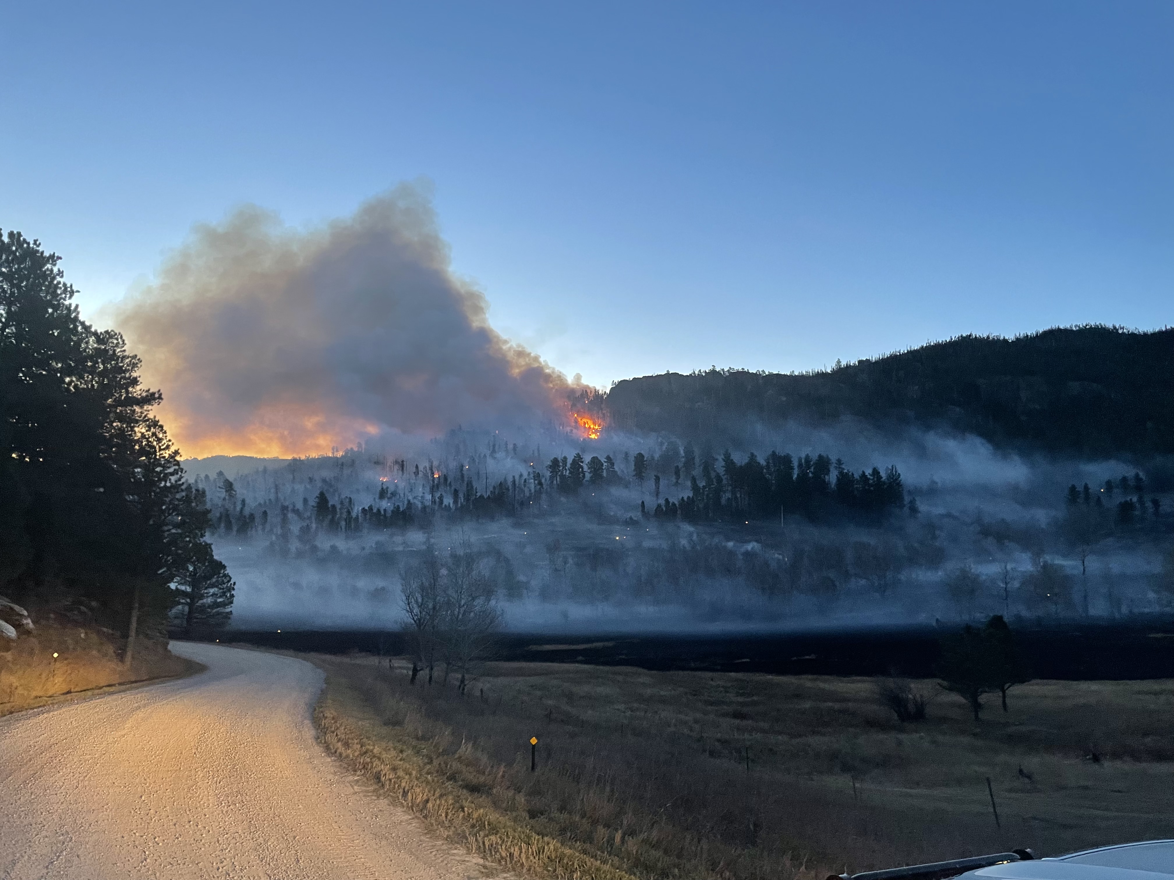
Observed fire behavior includes active ground fire with 4 to 6 feet flame lengths and occasional tree torching. The fire has burned the valley bottoms along Palmer Creek Road and on the above timbered ridge with heavy dead and down fuels, moving towards the Black Elk Wilderness.
 
A road closure on Palmer Creek Road is in place until further notice. For public safety, many trails in the Black Elk Wilderness Area are also closed. Trail numbers #2, #3, #4, #8, #9N, and #9S trail will be closed until further notice. Smoke will continue to be thick in the area for the next several days. The public is asked to avoid traveling on roads and trails in the vicinity of the fire for their own safety and the safety of firefighters.

Photo credit: Black Hills National Forest

Photo credit: Black Hills National Forest

Photo Credit: Black Hills National Forest

Update as of 1:30 PM, October 30, 2022


The Palmer Gulch wildfire is located in Pennington County, 3 miles southeast of Hill City was reported on October 29, at approximately 1:00 pm. The cause is under investigation.  Federal, State, Local, and Air resources have responded and are on scene.


The fire is burning on Black Hills National Forest lands, near the Black Elk Wilderness. The fire burned actively throughout the night as crews worked to place handline around the fire. Currently, the fire is burning in heavy dead and downed timber and estimated at 60 acres.


A road closure on Palmer Creek Road is in place until further notice. For public safety, many trails in the Black Elk Wilderness Area are also closed. Trail numbers #2, #3, #4, #8, #9N, #9S and Cathedral Spires trail will be closed until further notice. Smoke will continue to be thick in the area for the next several days. The public is asked to avoid traveling on roads and trails in the vicinity of the fire for their own safety and the safety of firefighters.

Low winds will contribute to poor smoke dispersal for local communities. Cool temperatures and no precipitation are forecasted for the next several days until Wednesday when a cold front approaches the Black Hills.

Photo credit: Black Hills National Forest

Photo credit: Black Hills National Forest

Photo credit: Black Hills National Forest


Update as of 9:00 AM, October 30, 2022

An estimated 15 acres of fire growth took place overnight toward the wilderness.  

Resources today will include a fixed wing Air Attack platform and a National Guard helicopter.  Federal, state, and local firefighters will continue the interagency effort on the ground.  Firefighters will work on suppression and mop up efforts throughout the day.

Fire Weather Update from the National Weather Service:

Afternoon highs are forecast to reach the mid 60s to mid 70s, with minimum relative humidity values expected to fall into the 15 to 25 percent range. Strongest winds will likely occur across northeastern WY and south central SD, where sustained winds of 20 to 25 mph and gusts to around 35 mph will be possible. This combination of temperatures, relative humidity, and winds would lead to critical fire weather conditions. Similar conditions may linger across south central SD into Wednesday, though confidence is lower compared to Tuesday.


Update as of 6:00 PM, October 29, 2022

Estimated size is now 50 acres. The fire is currently being mapped; a more accurate number for acreage is anticipated momentarily. 

The Palmer Creek Road is closed and is expected to remain closed until at least tomorrow.

The Palmer Creek Trail is closed and will remain closed until it is deemed safe for the public. 

There are no evacuations in place.

An air attack platform flew the fire and reported that the State dozer was making good progress towards containment. Firefighters continue to suppress any active areas of the fire using fire line and engine work.

Two engines will staff the fire overnight and mop up is anticipated to continue the next couple of days.

A Temporary Flight Restriction (TFR) is in place.  All aircraft - including drones - are prohibited from flying within the TFR. 


Update as of 3:12 PM, October 29, 2022

Estimated size is now 15 acres


Update as of 2:49 PM, October 29, 2022

Reported: 12:49 pm, October 29, 2022

Location: Black Elk Wilderness roughly near the Palmer Gulch Trailhead

Estimated size: 3-5 acres

Fuel Type: Grass and timber

Resources: Federal, state, and local.  A state dozer is enroute to assist.

Cause: Under investigation

Tuesday, October 25, 2022

October 25, 2022

Tigerville Fire

Reported: 1:46 pm, Oct 25, 2022

Location: 3 miles northwest of Hill City in Pennington County

Size: .2 acres

Resources: Federal, state and local

Cause: Under investigation


Friday, October 21, 2022

BLM Prescribed Burn - October 21, 2022 - Fort Meade Recreation Area, SD

 The Bureau of Land Management (BLM) plans to conduct a prescribed burn operation today in the Fort Meade Recreation area near Sturgis. Firefighters from the US Forest Service, South Dakota Wildland Fire Division, and local Volunteer Fire Departments are assisting the BLM in these operations.  

Objectives of this prescribed burn are to reduce forest density and hazardous fuels accumulations, expand habit for wildlife, and increase the health of native plants and hardwoods. This prescribed burn will also assist in reducing the risk of high intensity wildfire to people, communities, and natural resources. 

Today firefighters plan on burning 139 acres.  

The public should expect smoke to be visible for several days throughout the burn area.  Fire officials from the BLM will assess conditions and expected weather to determine if they will continue with burn operations tomorrow.

Questions about the burn can be directed to BLM Fire Management Officer, Travis Lipp, at 605-210-0741. 

Wednesday, October 19, 2022

BLM Prescribed Burn - October 19, 2022 - South of Lead, SD

 The Bureau of Land Management (BLM) plans to conduct a prescribed burn operation today in the Englewood area south of Lead. Firefighters from the US Forest Service, South Dakota Wildland Fire Division, and local Volunteer Fire Departments are assisting the BLM in these operations.  

Objectives of this prescribed burn are to reduce forest density and hazardous fuels accumulations, expand habit for wildlife, and increase the health of native plants and hardwoods. This prescribed burn will also assist in reducing the risk of high intensity wildfire to people, communities, and natural resources. 

Today firefighters plan on burning 89 acres.  

The public should expect smoke to be visible for several days throughout the burn area.  Fire officials from the BLM will assess conditions and expected weather to determine if they will continue with burn operations tomorrow.

Questions about the burn can be directed to BLM Fire Management Officer, Travis Lipp, at 605-210-0741. 

Tuesday, October 18, 2022

Oct 17, 2022

Bale Fire

Reported: 2:25 pm, Oct 17, 2022

Location: Crook County, 6 miles north of Hulett, WY

Size: 22.5 acres

Resources: Federal, state and local

Cause: under investigation

Contained at 6:30 pm, Oct 17

Monday, October 17, 2022

Oct 13-16, 2022

 K Bar S Fire

Reported: 4:23 pm, Oct 16, 2022

Location: K Bar S Ranch, West of Keystone, SD

Size: 2 acres

Resources: Federal, state and local

Cause: Under investigation


Cabin Fire

Reported: 4:08 pm, Oct 15, 2022

Location: 11 Miles S. of Long Pine, NE (in Brown County)

Size: .1 acre

Resources: Federal, local

Cause: Under investigation


Wildcat Gulch Fire

Reported: 2:09 pm, Oct 13, 2022

Location: 5 miles SW of Lead, SD (Lawrence County)

Size: .1 acre

Resources; Federal, state, local

Cause: Under investigation

Contained, controlled, out at 10:35 am, Oct 14. 


Medicine Bull Fire

Reported: 1:11 pm, Oct 13, 2022

Location: 6 miles N of Kennebec, SD (Lyman County)

Size: 60.2 acres

Resources: Federal, state and local

Cause: Under investigation

Contained and controlled at 4:05 pm, Oct 13.


Watson Fire

Reported: 12:56 pm, Oct 13, 2022

Location: 2.5 miles east of Hill City, SD

Size: .25 acres

Resources: Federal, state and local

Cause: under investigation'

Contained at 2:30 pm, Oct 13. 


Friday, October 7, 2022

Oct 7, 2022 - Fires from Oct 4 & 5

Power Fire

Reported: 6:34 am, Oct 4, 2022

Location: 1 mile SE of Pringle, SD

Size: .1 acre

Resources: Federal and Local

Cause: lightning

Contained and controlled: 8:32 am, Oct 4, 2022


Campground Fire

Reported 12:58 pm, Oct 5, 2022

Location: 15 miles SW of Chadron, NE, Dawes County

Size: 3.5 acres

Cause: lightning

Contained: 10:28 pm, Oct 5, 2022


Sunday, October 2, 2022

Oct 2, 2022

Dewey Road Fire

Reported: 5:37 pm, Oct 2, 2022

Location: 3 miles north of Edgemont, SD

Size: 13.72 acres

Resources: Federal and State

Cause: unknown 

Contained: 9:06 pm, Oct 2


Bovee Fire Update Oct 7, 2022

Reported: 12:38 pm, Oct 2

Location: 3 miles south of Halsey, NE

Size: 18,930 acres

Resources: Federal, State and Local

Cause: Under investigation

Containment: 97% as of Oct 7, 2022

Bovee Fire Update 

Friday, October 7, 2022 – 9:00 a.m. 

Rocky Mountain Complex Incident Management Team 1 

Dan Dallas, Incident Commander  

Information Phone: 402-302-0368 (public)  402-937-9090 (media only) 

Email: 2022.bovee@firenet.gov  

Information Staffing Hours: 8 a.m. to 8 p.m. 

Special Note: In our efforts to right size for current fire conditions on the Bovee Fire, today is the last shift for Rocky Mountain Complex Incident Management Team 1. At 7:00 am Saturday, management of the fire will transfer to a local Type 4 Incident Management Team. The Rocky Mountain team would like to thank all those who have worked so hard to assist us during our tenure here. This will be the last written update for the Bovee Fire, but updates may be posted on the Nebraska National Forests & Grasslands Facebook page as the situation warrants. 

Current Situation: The Bovee Fire is 18,930 acres and 97% contained. The fire is completely surrounded by fireline. Firefighters continue to work on improving the line, mopping up, and patrolling. Structure protection forces have completed assessments and will focus today on chipping fuels near structures. Residents should note that even though the fire is approaching full containment, smoke may be visible in the interior of the fire for some time. This is normal and does not present a threat. 

Division A: A UAS (Unmanned Aerial System or drone) found no heat near the line yesterday. Today, firefighters will continue to patrol the line and mop up any heat sources that may be found.  

Division Z: There is one small area of heat remaining inside the fireline on the south end of this division. Though inside the fireline, this heat source accounts for the 3% of the fire that remains uncontained. Today, firefighters will grid this area to ensure all hotspots are found and mop them up. The remainder of the Division will be patrolled. Hazard tree mitigation will occur on Road 201 and Trail 112. 

Division L: The UAS found two heat sources yesterday in the shelterbelt on the north end of the Division. Crews quickly mopped them up. Today, the focus will be on patrolling the fireline and mopping up any other hot spots that may be found. 

Weather,  Fuels, and Fire Behavior:  

Today will be the coldest day of the week with highs in the upper 40s, a minimum RH of 40%,and light/variable winds. A few scattered sprinkles are possible in the morning, but skies should clear in the afternoon. Saturday will see mostly sunny skies, highs in the upper 60s, and minimum RH of 40%. Winds will be light and out of the west. Fuels remain moist, and no additional fire spread is anticipated. 

Evacuations, Closures, and Fire Restrictions: 

There are no current evacuations on the Bovee Fire. 

Highway 2 is open, but please use caution as there will continue to be fire traffic in and around the fire area. 

An Area Closure encompassing the entire Bessey Ranger District is in place on the Nebraska National Forests and Grasslands. Fire restrictions are also in place on various parts of the Forests and Grasslands. For additional information on both, visit: https://www.fs.usda.gov/alerts/nebraska/alerts-notices 


Bovee Fire Statistics: 

Size:  18,932 acres  

Containment: 56% 

Total Personnel: 219 

Location: 3 mi. S. of Halsey, NE 

Reported: October 2, 2022 

Cause: human caused, under investigation 


For More Information: 

  Information Phone: 402-302-0368 (public) 

  Media only phone: 402-937-9090 

Email: 2022.bovee@firenet.gov 

  InciWeb: https://inciweb.nwcg.gov/incident/8437/ 

  Facebook: https://www.facebook.com/NebraskaForestsGrasslands/ 

  Twitter: https://twitter.com/USFSNebraska?ref_src=twsrc%5Egoogle%7Ctwcamp%5Eserp%7Ctwgr%5Eauthor 


Tuesday, September 27, 2022

BLM Prescribed Burn - Sep 26-27, 2022 - South of Lead, SD

The Bureau of Land Management (BLM) plans to continue prescribed burning operations today in the Englewood area south of Lead. Firefighters from the US Forest Service, South Dakota Wildland Fire Division, and local Volunteer Fire Departments are assisting the BLM in these operations.  

Objectives of this prescribed burn are to reduce forest density and hazardous fuels accumulations, expand habit for wildlife, and increase the health of native plants and hardwoods. This prescribed burn will also assist in reducing the risk of high intensity wildfire to people, communities, and natural resources. 

On Sep 26, firefighters were able to successful burn 87 acres and they anticipate burning 110 acres today, Sep 27.

The public should expect smoke to be visible for several days throughout the burn area.  Fire officials from the BLM will assess conditions and expected weather to determine if they will continue with burn operations tomorrow.

Questions about the burn can be directed to BLM Fire Management Officer, Travis Lipp, at 605-210-0741. 

September 26, 2022

Eden Wildfire

Reported: 2:01 pm, Sep. 26, 2022

Location: 1 mile east of Whitewood, SD

Size: 28.7 acres

Resources: Federal, State and Local

Cause: Human

Contained at 3:00 pm, Sep. 26, 2022


Sunday, September 25, 2022

Sep 23-24, 2022

Ruby Flats RX

On Sep 23, 2022, Lawrence County conducted a 1 acre burn 2.5 miles S-SE of Lead, SD (Exemption Area).


Butte Creek Fire

Reported: Sep 24, 2022 at 1:35 pm

Location: 14328 Old Hwy 212, Newell, SD

Size: 480 acres

Resources: Federal, State and Local

Cause: human

Contained Sep 24 at 2:00 pm, Controlled Sep 25 at 8:25 am.


Pit Fire

Reported: Sep 24, 2022 at 4:36 pm

Location: Spearfish Canyon Shooting Range

Size: 3 acres

Resources: Federal and local

Cause: human

Contained Sep 24 at 7:40 pm


Wednesday, September 7, 2022

September 7, 2022

Whitewater Creek Fire:

  • Reported @ 3:38 p.m. MST on September 7, 2022
  • Location: 10 miles SE of Wall, SD
  • Size: 20 acres
  • Cause: Unknown
  • Federal and Local resources responded.
  • Rumford Fire:

    • Reported @ 2:51 p.m. MST on September 7, 2022
    • Location: 6 miles East of Ardmore, NE
    • Size: 3.12 acres
    • Cause: Unknown
    • Federal and Local resources responded.


    Monday, September 5, 2022

    September 5, 2022 - Wildfire Update

    Basin Fire:

    • Reported @ 9:12 p.m. MST on September 4, 2022
    • Location: East of Pactola Reservoir in Pennington County, SD
    • Size: .1 acre
    • Cause: human, campfire
    • Federal, State, and Local resources responded.
    • Contained and Controlled @ 10:17 p.m. on September 4.

    Crow Creek Fire:

    • Reported @ 8:22 a.m. MST on September 4, 2022
    • Location: approx. 4 miles West of Custer, SD
    • Size: .1 acre
    • Cause: human, campfire
    • Federal resources responded.
    • Contained and Controlled @ 9:30 a.m. on September 4.


    Wednesday, August 31, 2022

    August 31, 2022 - Wildfire Update

    Updated 5:50 p.m. on August 31, 2022


    Choke Cherry Fire:

    ·       Reported @ 12:40 p.m. MST on August 31, 2022

    ·       Location: 8 miles Southeast of Thedford, NE along Gaston Road

    ·       Size: 169 acres

    ·       Cause: lightning

    ·       Federal resources responded with earlier support from a Single-Engine Air Tanker.

    ·       Contained @ 5:50 p.m. August 31.


    Matias Fire:

    ·       Reported @ 11:43 a.m. MST on August 31, 2022

    ·       Location: 8 miles North of Edgemont, SD in Fall River County

    ·       Size: 2 acres

    ·       Cause: Lightning

    ·       Federal, State, and Local resources are responding.

    ·       Contained @ 2:30 p.m. and Controlled at 4:30 p.m. on August 31.


    Tail Fire:

    ·       Reported @ 10:42 a.m. MST on August 31, 2022

    ·       Location: near Black Hawk, SD

    ·       Size: .01 acre

    ·       Federal and Local resources responded.

    ·       Cause: Human debris

    ·       Contained @ 11:!5 a.m. and Controlled at 12:49 p.m. on August 31.

    Ash Hollow Fire:

    ·       Reported @ 10:18 a.m. MST on August 31, 2022

    ·       Location: 6 miles East of Chadron, NE on Redfern Road

    ·       Size: .01 acre

    ·       Federal and Local resources responded.

    ·       Cause: Lightning

    ·       Contained @ 11:28 a.m. on August 31.