Saturday, August 28, 2021


August 30, 2021

Updated: 30 Aug 2021 7:45 AM MDT

Middle Fork Fire / Fire Update at 7:32 p.m. on Saturday, August 28, 2021

Reported: 3:24 p.m.

Location: 2.5 miles northwest of Aladdin, WY

Size: 3.8 acres

Resources: Federal and county

Cause: Lightning

Contained: 7:30 p.m. (Updated on Saturday, August 28, 2021)


Choke Cherry Fire / Fire Update at 7:45 a.m. on August 30, 2021

Reported: 2:18 p.m.

Location: 15 miles south of Thedford, NE and east of Hwy 83

Size: 52 acres

Resources: Federal and county

Cause: Lightning (Updated on Monday, August 30, 2021)

Contained: 4:36 p.m.

Friday, August 27, 2021


Great Plains Fire Information


August 30, 2021

Posted: 30 Aug 2021 07:50 AM MDT

Schmitcan Fire / Fire Update at 7:50 a.m. on August 30, 2021

Reported: 11:40 a.m.

Location: East of Devils Tower National Monument at Shaw Rd. and Brimmer Divide Area

Size: 25 acres acres (Updated on Monday, August 30 at 7:50 a.m.)

Resources: Federal and county

Cause: Lightning

Contained: 2:15 pm

Controlled: 3:45 pm

UPDATE: The fire rekindled on Sunday, August 29, 2021 and started burning again. Crews are   on scene.


Tuesday, August 24, 2021

August 24, 2021

Canyon Lane Fire

Reported: 1:01 p.m.

Location: Butte County, 2 miles south of Belle Fourche, SD

Size: 5.6 acres

Resources: State, local

Cause: Unknown

Contained: 2:30 p.m.

Sunday, August 22, 2021

August 22, 2021

Risse Fire

Reported: 4:15 p.m.

Location: Bennett County, 7 miles northeast of Allen, SD

Size: 15 acres

Resources: Tribal, local

Cause: Unknown

Wolf Fire

Reported: 2:13 p.m.

Location: Fall River County, 5 miles east of Edgemont, SD

Size: 12.8 acres

Resources: Federal, state, local

Cause: Unknown

Contained: 4:50 p.m.

Controlled: 2:00 p.m. August 23

Whitelaw Fire

Reported: 12:07 p.m.

Location: Crook County, 8 miles northwest of Sundance, WY

Size: 0.1 acre

Resources: Federal

Cause: Unknown

Contained: 12:30 p.m.

Controlled: 12:45 p.m.

Out: 1:00 p.m.

Little Sleep Fire

Reported: 4:17 a.m.

Location: Jackson County, 12 miles east of Kyle, SD

Size: 447 acres

Resources: State, local

Cause: Unknown


Saturday, August 21, 2021

August 21, 2021

Snake River CA Fire

Reported: 6:08 p.m.

Location: Cherry County, 20 miles southwest of Valentine, NE

Size: 2 acres

Resources: Federal, state, local

Ranger Station Fire

Reported: 2:30 p.m.

Location: Samuel R. McKelvie National Forest, Cherry County, 13 miles south of Nenzel, NE

Size: 1.3 acres

Resources: Federal

Cause: Unknown

Iron Shoe Fire

Reported: 11:58 a.m.

Location: Custer County, 3 miles southwest of Argyle, SD

Size: 0.5 acre

Resources: State, local

Cause: Unknown

Contained: 3:45 p.m.

Controlled: 5:00 p.m.

Thursday, August 19, 2021

August 19, 2021

Selliez Fire

Reported: 11:45 a.m.

Location: Crook County, 11 miles north of Sundance, SD

Size: 0.1 acre

Resources: Federal

Cause: Lightning

Contained: 12:00 p.m.

Controlled: 12:15 p.m.

Out: 12:30 p.m.

Wednesday, August 18, 2021

August 18, 2021

Hawk Draw CA Fire

Reported: 11:53 pm, August 17, 2021

Location: Pennington County, I-90 MM 96, near Wasta, SD

Size: 350 acres

Resources: Federal, state, local 

Cause: Human

Contained: 11:30 a.m. August 19

Controlled: 12:00 p.m. August 19

Minute Man Fire

Reported: 5:38 pm, August 18, 2021

Location: Jackson County, I-90 MM 130, near Cottonwood, SD

Size: 0.1 acre

Resources: Federal 

Cause: Unknown

Contained: 6:15 p.m.

Controlled: 6:20 p.m.

Out: 6:28 p.m.

Tuesday, August 17, 2021

August 17, 2021

Carroll Creek Fire

Reported: 12:16 pm, August 17, 2021

Location: Custer County, in Sanator, SD

Size: 0.1 acres

Resources: Federal, local 

Cause: Unknown

Contained and controlled: 1:20 p.m. August 17, 2021

118 CA Fire

Reported: 5:08 pm, August 17, 2021

Location: Morrill County, 4 miles east of Angora, NE

Size: 6,000 acres

Resources: Local 

Cause: Unknown

Monday, August 16, 2021

August 15, 2021

River South Fire

Reported: 11:55 am, August 15, 2021

Location: Cherry County, 10 miles south of Nenzel, NE, or 27 miles southwest of Valentine, NE

Size: 100 acres

Resources: Federal 

Cause: Unknown

Contained: 6:30 pm, August 15, 2021


River Trees Fire

Reported: 3:03 pm, August 15, 2021

Location:  Cherry County, NE 9 miles south of Nenzel, NE or 24 miles southwest of Valentine, NE.

Size: .1 acre

Resources: Federal

Cause: Unknown

Contained: 4:00 pm, August 15, 2021


Saturday, August 14, 2021

August 13, 2021

Crook City County Assist (CA)

Reported: 10:30 am, August 13, 2021

Location: Just west of Whitewood, SD on Crook City Road

Size: 2.5 acres

Resources: Federal, State and Local

Cause: Unknown

Contained and controlled at 11:45 am, August 13, 2021


Angel Fire

Reported: 11:45 am, Aug 13

Location: Meade County

Size: 11.65 acres

Cause: unknown 

Resources: State and local 

Contained at 7:25 pm, Aug 13

August 14, 2021

Avalanche Fire

Reported: 10:27 am, Aug 14

Location: Avalanche Road, North or Sturgis

Size: 5.77 acres

Cause: unknown

Resources: State

Contained at 11:00 am, Aug 14


Ball Park Fire

Reported: 12:02 pm, Aug 14

Location: Ball Park

Size: .1 acre

Cause: unknown

Resources: Local

Contained, controlled and out at 1:15 pm, Aug 14


Old Highway 16 (CA)

Reported: 1:18 pm, August 14, 2021

Location; Lyman County, SD; NW of town of Lyman 1 mile

Size: 160.9 acres

Cause: Unknown

Resources: State and Local

Contained and Controlled at 1:12 am, August 15, 2021


Black and White (CA) Fire

Reported: 3:40 pm, Aug 14

Location: I-90 MM 101

Size: 1.2 acres

Cause: 

Resources: State and local

Contained and controlled at 5:00 pm, Aug 14.

Thursday, August 12, 2021

August 12, 2021

Hisega Fire

Reported: 3:03 p.m., August 12, 2021

Location: Pennington County, SD - Hisega

Size: .10 acre

Resources: State

Cause: Unknown

Contained: 4:38 p.m., August 12, 2021

Cross (CA) Fire - Updated

Update 6:00 pm, August 12, 2021

Cross County Assist (CA) Fire

Reported: 12:28 pm, August 11, 2021

Location: Approximately 6 miles southwest of Scottsbluff, NE

Size: 2460 acres

Resources: Federal, State and Local

Cause: Unknown

Containment: 


Wednesday, August 11, 2021

Kirk Hill Fire - Updated

Kirk Hill Fire taken 8/12/21 by Brian Rafferty, Black Hills National Forest/USDA Forest Service
Kirk Hill Fire taken 8/11/21 by Brian Rafferty, Black Hills National Forest/USDA Forest Service

August 12, 2021 - 7:00 p.m. News Release

 Fire fighters worked throughout the day to secure the perimeter of the Kirk Hill fire.  The fire was 100 % contained today at 5:00 p.m.

Crews will continue to patrol and conduct mop up operations in the coming days. Smoke will be present for the next several days as well.

The size of the fire is approximately 80 acres.

No structures were lost in the fire.

Numerous federal, state and local resources responded, including a type 1 and type 3 helicopter, dozers, engines, hand crews and the Tatanka Hotshots. A heavy air tanker also responded and dropped several loads of retardant. 

 August 12, 2021 - 8:00 a.m.  News Release

Firefighters worked through the night to suppress the Kirk Hill wildfire that started yesterday afternoon near Sturgis, S.D. and burned approximately 80 acres.

Fire officials stated they have a line around the fire with a combination of dozer lines, hand lines and roads. Crews will focus on mopping up the perimeter today to gain full containment.

The predicted favorable weather conditions (cooler temperatures and higher relative humidity) today will aid the firefighting effort.

Smoke will be present for the next several days.

No structures were lost in the fire.

Numerous federal, state and local resources responded, including a type 1 and type 3 helicopter, dozers, engines, hand crews and the Tatanka Hotshots. A heavy air tanker also responded and dropped several loads of retardant.  


Update as of 7:00 pm, August 12, 2012

Kirk Hill Fire

Reported: 2:42 pm, August 11, 2021

Location: Lawrence County, 5 miles southwest of Sturgis, 7 miles west of Tilford, 3.75 miles northeast of Roubaix.

Size:  80 acres

Resources: Federal, State and local. Multiple ground and air resources including type 1 and typ3 helicopter, heavy air tanker and Tatanka Hot Shots.

Cause: Unknown

Containment:  100% contained at 5:00 p.m., August 12, 2021


August 11, 2021 News Release 

A wildfire is currently burning at Kirk Hill, located approximately 5 miles southwest of Sturgis, S.D.

 Numerous federal, state and local resources are responding, including a type 1 and type 3 helicopter, dozers, engines, hand crews and the Tatanka Hotshots. A heavy air tanker is on scene. 

 At 5:00 p.m., the fire was estimated at 40 acres.


Tuesday, August 10, 2021

August 10, 2021- Updated

Update as of 8:00 am, August 11, 2021

Tompson (CA) Fire

Reported: 1:58 pm, August 10, 2021

Location:  Stanley County, 23 miles west of Fort Pierre. Tompson Ranch

Size: 602.9 acres

Resources: Federal / State / Local


Nail Creek (CA) Fire

Reported: 5:54 pm, August 10, 2021

Location: Presho Road and 326th Street

Size: 74.1 acres

Resources: Federal, State and local

Cause: Human


Sunday, August 8, 2021

August 8, 2021

Harlan Fire

Reported:  4:32 PM

Location: 11 miles NW Newport, NE

Size: 5 acres

Resources: State - Single Engine Airtanker (SEAT) based in Chadron 

Cause: Power Line

Contained: 6:00 PM


Saturday, August 7, 2021

August 7, 2021

Update for Bennett Canyon Fire

Bennett Canyon Fire

Update as of 9:00 am, August 9, 2021 - 

Reported at 4:05 PM

Location: Custer County, 3 miles SE of Dewey

Size: 13.74 acres

Cause:  Lightning 

Resources: Federal, State, Local, 2 single engine air tankers, 1 type 3 helicopter

Contained:  9:38 AM, August 8, 2021- crews continue to mop up. 


#3. Painter Fire - County Assist

Reported: 10:57 AM

Location: 15.75 miles SSW of Crawford, NE

Size: 0.5

Cause: Unknown, Fire on 1/2 acre of grass and one hay bale

Resources: Federal and local VFD

Contained: 1:30 PM


#2. Simkins Fire

Reported: 9:49 AM

Location: 5 miles SW Hill City 

Size: 0.1 acre

Cause: Lightning

Resources: Federal & State 

Contained: 3:20; Control 4:15 PM


#1. Mountain Goat Fire

Reported: 8/6/2010/at 7:42 PM. Crews first arrived on site 8/7/2021 at 10:30 AM

Location: 0.5 mi N Victoria Lake

Size: 0.1 acre

Cause: Lightning

Contained: 2:30 PM; Control 4:40  PM


UPDATE for Iron Fire;

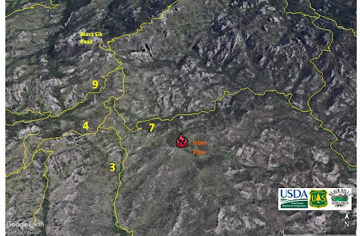
Iron Fire

Update as of 9:00 am, August 9, 2021 - The fire has been contained and controlled.  The Trailhead parking areas and hiking trails that were closed are now open to the public.  

Reported: 3:17 PM on 8/6/2021

Location: Custer County, 1 mile SE Black Elk Peak in Black Elk Wilderness.

Size: 1.19 acre 

Resources: State and Federal - SDNG Blackhawk Helicopter and Type 3 Helicopter

Contained: 7:00 pm, August 7 

Controlled: 4:00 pm, August 8

Cause: Lightning


UPDATE for Hackberry Fire; Morning of 8/9/2021

Hackberry Fire - County Assist

Reported: 7:14 pm on August 5, 2021 

Location: 30 miles S of Scottsbluff and Gering, NE; on border of Banner and Morrel County

Jurisdiction: Fire started on private land, burned into county. Incident command taken over by Nebraska State IMT, Type 3. 

Size: 5,778 acres

Cause: Lightning 

Resources: Several engines from Mutual Aide VFD response, 3 Single Engine Air Tankers (SEATS) and 2 National Guard Helicopters and Large Tanker from Colorado

Friday, August 6, 2021

August 6, 2021

**Note - missing fire numbers usually indicate False Alarms*** 


#20. Tops Fire

Reported: 7:38 PM

Location: 

Size: 0.1 acre

Resources: Federal, State

Contained: 9:56 PM Control: 10:30 PM 


#17. South Highlands Fire

Reported: 7:12 PM

Location: Custer County, 2 miles SE Elk Mountain

Size: 0.1 acre

Cause: Lightning 

Resources: Federal, State & Local


#15. Cottonwood Fire - County Assist

Reported: 7:06 PM

Location: Montrose Area, 3 miles N Gilbert Baker Wildlife Management Area

Size: 0.1 acre

Resources: Federal


#16. Stage Run Fire

Reported: 6:39 PM

Location: Pennington County, by Mount Rushmore

Size: 0.1 acre

Cause: Lightning

Resources: Federal & State

Contained / control: 7:15 PM


#15. Airport Road - County Assist

Reported: 6:38 PM

Location: Dawes County, near airport

Size: 35 acres

Cause: Lightning

Contained: 6:41 PM, Control 8:30 PM


#13. Pleasant Ridge Fire - County Assist

Reported: 5:39 PM 

Location: West side of Hwy #385, just N of NE / SD State Line

Size: 91.16 acres

Cause: Lightning

Resources: Federal & Local

Contained: 7:50 PM


#11. Grove Fire

Reported: 5:16 PM

Location: NE of Keystone, SD 

Size: 0.84

Cause: Lightning

Resources: Federal & local 


#10. Grizzly Bear Fire

Reported: 5:01 PM

Location: Pennington County; 1.5 miles SW Mount Rushmore

Size: 0.1 acre

Resources: Federal

Contained / control: 7:58 PM / 8:20 PM


#9. Antelope Fire

Reported: 4:50 PM

Location: Fall River County, W of Ardmore

Size: 2.27 acres

Cause: Lightning

Contain/Control/Out: 1:45 PM on 8/8/2021


#8. Pink Schoolhouse Fire

Reported: 4:36 PM

Location: Agate Fossil Beds

Size: 0.1 acres

Resources: Federal, local 


#6. Palmer Fire

Reported: 4:25 PM

Location: Pennington County, 2 miles e Oreville 

Size: 0.1 acre 

Cause: Lightning

Resources: Federal


#3. Old Baldy Fire

Reported: 3:33 PM

Location: Pennington County, Mt. Baldy

Size: 0.1 acre

Resources: Federal, State & Local

Contained: 7:15 PM


Iron Fire

Reported: 3:17 PM

Location: Custer County, 1 mile SE Black Elk Peak

Size: 1 acre 

Resources: Federal


#2. Rim Rock Fire

Reported: 2.05 PM

Location: 1.5 - 2 miles south of Cook Lake

Size: 2 acres

Cause: Lightning

Resources: Federal, Local, State


#1. Railroad Fire - County Assist

Reported: 1:48 PM

Location: 0.5 mile north of Dunning, NE

Size: 1 acre

Resources: Federal

Contained, Control and Out: 2:30 PM


Thursday, August 5, 2021

August 5, 2021 - Updated

Hackberry Fire - County Assist

Reported: 7:14 pm

Location: South of Scottsbluff and Gering, NE

Size: 6,177 acres

Cause: Unknown

Resources: Several engines from Mutual Aide VFD response, 3 Single Engine Air Tankers (SEATS) and 1 National Guard Helicopter


Link Fire - County Assist

Reported: 3:02 PM

Location:  23 miles north of Wall, SD

Size:  80 acres

Cause:  Human caused. Equipment

Resources:  Federal, local

Contained: 5:08 PM


Sterling Fire - County Assist

Reported 12:22 PM

Location: Stanley county, 11 miles west of Ft. Pierre, along Hwy # 14/34

Size: 0.2 acre

Cause:  Unknown

Resources: Federal, Local VFD


Scotty Fire - County Assist

Reported: 12:22 PM

Location: stanley county, along Hwy # 14/34

Size: 0.1 acre

Cause:  Unknown

Resources: Federal, Local VFD

Contained: 1:14 PM

Wednesday, August 4, 2021

August 4, 2021

Kneebone Fire

Reported at: 5:56 PM

Location: 10 miles SE Smithwick, SD, federal land

Size: 11.86 acres

Cause: Lightning

Resources: Federal & State

Contained: 9:00 PM


August 3, 2021

 Reported 8/4/2021

Moco Fire, County Assist

Reported: 1:36 PM on 8/3/2021

Location: Lyman County, 15 miles N Presho, SD

Size: 23.3 acres

Resources: Federal & Local

Cause: Human - Equipment


Monday, August 2, 2021

August 2, 2021

Fire:  McCarthy Fire - County Assist

Reported at 4:59 PM

Location: 12 miles north of Pierre

Size: 97.7

Cause:  Human - Equipment

Resources: Federal, state & local

Contained at 5:29 PM


Fire: Chicago Fire

Reported at 2:08 PM

Location:  13 miles east of Sundance, federal and private land

Cause:  Unknown

Size:  0.39

Resources: Federal, local and Helicopter

Contained: 5:15 PM


Fire: Stage Stop

Reported at 1:12 PM

Location: 0.5 miles east of Piedmont, mile marker 46 off I-90, grass fire

Size: 0.1 acre, state  and forest

Cause: Human

Resources: State & local

Contained and controlled at 1:30 PM


Fire: South Fork Fires, 1 through 6

Reported: 10:01 AM

Location: 10 Miles west of Edgemont along Hwy. #18, near the Wyoming State Line. Private land and US Forest Service

Size 41.4 acres, private

Resources: Federal, state and local

Cause: Human, Equipment 

Contained at 3 pm


Sunday, August 1, 2021

August 1, 2021


Fire #3: Silver Creek Fire

Reported: 4:00 PM

Location: 3 mi. N of Rochford

Size: 0.5 acre

Cause: Lightning

Resources: State, Federal and helicopter for bucket dumps

Contained: 7:20 PM; Control: 8:05 PM


Fire #2: Mile Marker 120

Reported: 1:54 PM

Location: Mile Marker 120 along I-90, federal land

Size: 0.5 miles

Cause: Human

Resources: Local and federal

Contained: 2:30 PM 


Fire #1: Lyman Fire

Reported: 10:30 AM

Location: Custer County, 6 miles SW of Jewel Cave

Size: 21.6 acres

Resources: Federal, state & local